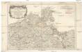
Maps of Colberg County

93. Kolberg. (Germany)
1 : 100000 Reichsamt fur Landesaufnahme
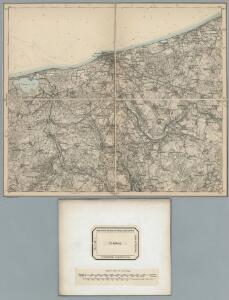
Composite: 93. Kolberg. (Germany)
1 : 100000 Reichsamt fur Landesaufnahme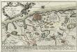
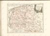
Plan der Belagerung von Colberg vom 3. Oct. bis 1. Nov. 1758
Mollova mapová sbírka
Composite: 92. Treptow a. d. Rega. (Germany)
1 : 100000 Reichsamt fur Landesaufnahme
Meßtischblatt 1960 : Kerstin, 1940
1 : 250000 Kerstin. - Aufn. 1888, hrsg. 1890, bericht. 1938. - 1:25000. - [Berlin]: Reichsamt für Landesaufnahme, 1940. - 1 Kt.
Meßtischblatt 1959 : Gr. Jestin, 1942
1 : 250000 Gr. Jestin. - Aufn. 1889, hrsg. 1891, bericht. 1938. - 1:25000. - [Berlin]: Reichsamt für Landesaufnahme, 1942. - 1 Kt.
Meßtischblatt 603 : Gützlaffshagen, 1929
1 : 250000 Gützlaffshagen. - Hrsg. 1891, einz. Nachtr. 1929. - 1:25000. - [Berlin]: Reichsamt für Landesaufnahme, 1929. - 1 Kt.
Meßtischblatt 1860 : Degow, 1941
1 : 250000 Degow. - Aufn. 1889, hrsg. 1891, bericht. 1938. - 1:25000. - [Berlin]: Reichsamt für Landesaufnahme, 1941. - 1 Kt.
Meßtischblatt 1859 : Kolberg, 1936
1 : 250000 Kolberg. - Hrsg. 1890, Nachtr. 1924. - 1:25000. - [Berlin]: Reichsamt für Landesaufnahme, 1936. - 1 Kt.
Meßtischblatt 1858 : Langenhagen, 1934
1 : 250000 Langenhagen. - Hrsg. 1890, einz. Nachtr. 1929. - 1:25000. - [Berlin]: Reichsamt für Landesaufnahme, 1934. - 1 Kt.
Meßtischblatt 1760 : Lassehne, 1940
1 : 250000 Lassehne. - Aufn. 1889, hrsg. 1890, bericht. 1938. - 1:25000. - [Berlin]: Reichsamt für Landesaufnahme, 1940. - 1 Kt.
29. Kolberg, uit: Topographische Uebersichtskarte des Deutschen Reiches / herausgegeben v. d. Kartogr. Abt. d. Königl. Preuß. Landesaufnahme
1 : 200000 titelvariant: Topogr. Übersichtskarte des Deutschen Reiches; Annotatie: Titel boven bladen ook: Topogr. Übersichtskarte des Deutschen Reiches; Annotatie geografische gegevens: Op elk blad twee maatstokken: 10 Kilometer = 5,5 cm; 1 geogr. Meile = 3,6 cm; Legenda onder op elk blad Königlich Preußische Landesaufnahme. Kartographische Abtheilung [S.l : Königlich Preußische Landesaufnahme, Kartographische Abtheilung]
Meßtischblatt 2060 : Ramelow, 1943
1 : 250000 Ramelow. - Hrsg. 1891, bericht. 1938. - 1:25000. - [Berlin]: Reichsamt für Landesaufnahme, 1943. - 1 Kt.
Meßtischblatt 2059 : Roman, 1940
1 : 250000 Roman. - Hrsg. 1891, bericht. 1938. - 1:25000. - [Berlin]: Reichsamt für Landesaufnahme, 1940. - 1 Kt.
Meßtischblatt 2058 : Kölpin, 1941
1 : 250000 Kölpin. - Hrsg. 1891, bericht. 1938. - 1:25000. - [Berlin]: Reichsamt für Landesaufnahme, 1941. - 1 Kt.
Meßtischblatt 602 : Treptow (An der Rega), 1890
1 : 250000 Treptow (An der Rega). - Aufn. 1889. - 1:25000. - [Berlin]: Reichsamt für Landesaufnahme, 1890. - 1 Kt.
Meßtischblatt 519 : Robe, 1912
1 : 250000 Robe. - Aufn. 1889, hrsg. 1890, einz. Nachtr. 1912. - 1:25000. - [Berlin]: Reichsamt für Landesaufnahme, 1912. - 1 Kt.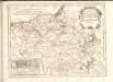

Colberg 24, uit: Special-Karte von Mittel-Europa / nach amtlichen Quellen bearbeitet von W. Liebenow
1 : 300000 titelvariant: W. Liebenow's Mittel-Europa; Annotatie: Titel boven de bladen: W. Liebenow's Mittel-Europa Johannes Wilhelm Liebenow 1822-1897 Frankfurt a. M. : Ludwig Ravenstein
124. Schivelbein. (Germany)
1 : 100000 Reichsamt fur Landesaufnahme
Composite: 124. Schivelbein. (Germany)
1 : 100000 Reichsamt fur Landesaufnahme
92. Treptow a. d. Rega. (Germany)
1 : 100000 Reichsamt fur Landesaufnahme
94. Coslin. (Germany)
1 : 100000 Reichsamt fur Landesaufnahme
Composite: 94.1. Koslin. (Germany)
1 : 100000 Reichsamt fur Landesaufnahme
Meßtischblatt 1861 : Kordeshagen, 1938
1 : 250000 Kordeshagen. - Aufn. 1889, hrsg. 1890, bericht. 1936. - 1:25000. - [Berlin]: Reichsamt für Landesaufnahme, 1938. - 1 Kt.
Meßtischblatt 1961 : Belgard (Persante), 1938
1 : 250000 Belgard (Persante). - Aufn. 1889, hrsg. 1890, bericht. 1936, letzte Na. - 1:25000. - [Berlin]: Reichsamt für Landesaufnahme, 1938. - 1 Kt.
Meßtischblatt 688 : Greifenberg, 1929
1 : 250000 Greifenberg. - Hrsg. 1890, einz. Nachtr. 1929. - 1:25000. - [Berlin]: Reichsamt für Landesaufnahme, 1929. - 1 Kt.
Mapa Wojewodztwa Szczecinskiego