Maps of gmina Dubeninki

78. Mehlkehmen. (Germany)
1 : 100000 Reichsamt fur Landesaufnahme
Composite: 78. Mehlkehmen. (Germany)
1 : 100000 Reichsamt fur Landesaufnahme
Meßtischblatt 17101 : Dubeningen, 1936
1 : 250000 Dubeningen. - Hrsg. 1925, einz. Nachtr. 1928. - 1:25000. - [Berlin]: Reichsamt für Landesaufnahme, 1936. - 1 Kt.
Meßtischblatt 17100 : Gurnen, 1926
1 : 250000 Gurnen. - Aufn. 1921. - 1:25000. - [Berlin]: Reichsamt für Landesaufnahme, 1926. - 1 Kt.
Meßtischblatt 17102 : Unterfelde, 1938
1 : 250000 Unterfelde. - Aufn. 1922, hrsg. 1926, einz. Nachtr. 1928, reda. - 1:25000. - [Berlin]: Reichsamt für Landesaufnahme, 1938. - 1 Kt.
Meßtischblatt 16101 : Rominten, 1941
1 : 250000 Rominten. - Aufn 1920, hrsg. 1925, letzte Nachtr. 1940. - 1:25000. - [Berlin]: Reichsamt für Landesaufnahme, 1941. - 1 Kt.
Meßtischblatt 16100 : Hardteck, 1938
1 : 250000 Hardteck. - Aufn 1921, hrsg. 1925, redakt. Änd. 1938. - 1:25000. - [Berlin]: Reichsamt für Landesaufnahme, 1938. - 1 Kt.
Meßtischblatt 16102 : Wehrkirchen, 1936
1 : 250000 Wehrkirchen. - Hrsg. 1924, einz. Nachtr. 1928. - 1:25000. - [Berlin]: Reichsamt für Landesaufnahme, 1936. - 1 Kt.
Meßtischblatt 15101 : Birkenmühle, 1941
1 : 250000 Birkenmühle. - Aufn. 1920, hrsg. 1925, letzte Nachtr. 1939. - 1:25000. - [Berlin]: Reichsamt für Landesaufnahme, 1941. - 1 Kt.
Meßtischblatt 15100 : Tollmingen, 1938
1 : 250000 Tollmingen. - Aufn. 1920/21, hrsg. 1926, redakt. Änd. 1938. - 1:25000. - [Berlin]: Reichsamt für Landesaufnahme, 1938. - 1 Kt.
Meßtischblatt 15102 : Gr. Kallweitschen, 1936
1 : 250000 Gr. Kallweitschen. - Hrsg. 1924. - 1:25000. - [Berlin]: Reichsamt für Landesaufnahme, 1936. - 1 Kt.
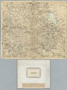
Germany 1:100,000 , Series GSGS 2739, (Sheet 17D)
This map series of which this is part - Germany 1:100,000 , Series GSGS 2739 - are reproductions of German mapping with English marginalia. Great Britain. General Staff. Geographical Section. [London] : [GSGS, War Office]
Sect. 17. Gumbinnen-Goldapp (Nord-Sudauen. Jetzt Littauen), uit: Geologische Karte der Provinz Preussen
1 : 100000 Annotatie: Incompleet; Voor aanwezige bladen zie bladoverzicht; Met inzetkaarten; Annotatie geografische gegevens: Coördinaten gebaseerd op nulmeridiaan van Ferro (Hierro) Berlin : Neumann
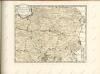
Suwalki 19, uit: Special-Karte von Mittel-Europa / nach amtlichen Quellen bearbeitet von W. Liebenow
1 : 300000 titelvariant: W. Liebenow's Mittel-Europa; Annotatie: Titel boven de bladen: W. Liebenow's Mittel-Europa Johannes Wilhelm Liebenow 1822-1897 Frankfurt a. M. : Ludwig Ravenstein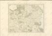

Schlacht an den Masurischen Seen
1 : 1000000 Masuren Schlacht, Weltkrieg <1914-1918>
77. Goldap. (Germany)
1 : 100000 Reichsamt fur Landesaufnahme
Composite: 77. Goldap. (Germany)
1 : 100000 Reichsamt fur Landesaufnahme
54. Stalluponen. (Germany)
1 : 100000 Reichsamt fur Landesaufnahme
Composite: 107. Marggrabowa. (Germany)
1 : 100000 Reichsamt fur Landesaufnahme
107. Marggrabowa. (Germany)
1 : 100000 Reichsamt fur Landesaufnahme
53. Gumbinnen. (Germany)
1 : 100000 Reichsamt fur Landesaufnahme
Meßtischblatt 1799 : Arnswald, 1938
1 : 250000 Arnswald. - Aufn. 1927, hrsg. 1934, letzte Nachtr. 1932, red. - 1:25000. - [Berlin]: Reichsamt für Landesaufnahme, 1938. - 1 Kt.
Meßtischblatt 1699 : Goldap, 1938
1 : 250000 Goldap. - Hrsg. 1925, red. Änd. 1938. - 1:25000. - [Berlin]: Reichsamt für Landesaufnahme, 1938. - 1 Kt.
Meßtischblatt 348 : Praßlauken, 1924
1 : 250000 Praßlauken. - Aufn. 1920. - 1:25000. - [Berlin]: Reichsamt für Landesaufnahme, 1924. - 1 Kt.
Meßtischblatt 14100 : Groß Trakehnen, 1938
1 : 250000 Groß Trakehnen. - Hrsg. 1925, redakt. Änd. 1938. - 1:25000. - [Berlin]: Reichsamt für Landesaufnahme, 1938. - 1 Kt.
Meßtischblatt 14101 : Schloßbach, 1941
1 : 250000 Schloßbach. - Aufn. 1914, hrsg. 1924, letzte Nachtr. 1939. - 1:25000. - [Berlin]: Reichsamt für Landesaufnahme, 1941. - 1 Kt.
Meßtischblatt 14102 : Grenzen (Ostpr.), 1936
1 : 250000 Grenzen (Ostpr.). - Hrsg. 1923. - 1:25000. - [Berlin]: Reichsamt für Landesaufnahme, 1936. - 1 Kt.