Maps of Barth

Composite: 62. Barth. (Germany)
1 : 100000 Reichsamt fur Landesaufnahme
62. Barth. (Germany)
1 : 100000 Reichsamt fur Landesaufnahme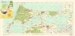
Bäderkarte Prerow Zingst Ahrenshoop Wustrow

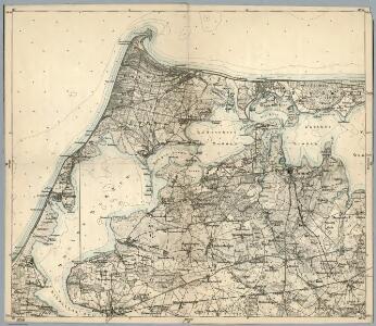
Meßtischblatt 370, neue Nr. 1642 : Barth, 1885
1 : 250000 Barth. - Aufn. 1884, hrsg. 1885. - 1:25000. - [Berlin]: Reichsamt für Landesaufnahme, 1885. - 1 Kt.
Meßtischblatt 369, neue Nr. 1641 : Lüdershagen, 1885
1 : 250000 Lüdershagen. - Aufn. 1884, hrsg. 1885. - 1:25000. - [Berlin]: Reichsamt für Landesaufnahme, 1885. - 1 Kt.
Meßtischblatt 311 : Zingst, 1936
1 : 250000 Zingst. - Hrsg. 1885, bericht. 1924. - 1:25000. - [Berlin]: Reichsamt für Landesaufnahme, 1936. - 1 Kt.
Meßtischblatt 1541 : Prerow, 1932
1 : 250000 Prerow. - Hrsg. 1885, bericht. 1924, letzte Nachtr. 1932. - 1:25000. - [Berlin]: Reichsamt für Landesaufnahme, 1932. - 1 Kt.
Meßtischblatt 368, neue Nr. 1640 : Wustrow, 1885
1 : 250000 Wustrow. - Aufn. 1884, hrsg. 1885. - 1:25000. - [Berlin]: Reichsamt für Landesaufnahme, 1885. - 1 Kt.
Meßtischblatt 309 : Ibenhorst, 1936
1 : 250000 Ibenhorst. - Hrsg. 1885, bericht. 1924. - 1:25000. - [Berlin]: Reichsamt für Landesaufnahme, 1936. - 1 Kt.
Meßtischblatt 437 : Velgast, 1927
1 : 250000 Velgast. - Hrsg. 1885, bericht. 1927. - 1:25000. - [Berlin]: Reichsamt für Landesaufnahme, 1927. - 1 Kt.
Meßtischblatt 436 : Ahrenshagen, 1885
1 : 250000 Ahrenshagen. - Aufn. 1884. - 1:25000. - [Berlin]: Reichsamt für Landesaufnahme, 1885. - 1 Kt.
Meßtischblatt 435 : Ribnitz, 1885
1 : 250000 Ribnitz. - Aufn. 1884. - 1:25000. - [Berlin]: Reichsamt für Landesaufnahme, 1885. - 1 Kt.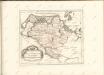

Theatrum belli in Pomerania citeriore
1 : 220000 Mollova mapová sbírka Berger
Stralsund 23, uit: Special-Karte von Mittel-Europa / nach amtlichen Quellen bearbeitet von W. Liebenow
1 : 300000 titelvariant: W. Liebenow's Mittel-Europa; Annotatie: Titel boven de bladen: W. Liebenow's Mittel-Europa Johannes Wilhelm Liebenow 1822-1897 Frankfurt a. M. : Ludwig Ravenstein
Mappa Ducatus Megalopolitani Nova :
1 : 190000 Mollova mapová sbírka
Karte von Neu-Vorpommern und der Insel Rügen
1 : 200000 Přední Pomořansko (Německo) Hagenow, Fr. von Hube, C. A. Fr. v. Hagenow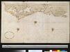
Gedeelte van de kust van Mecklenburg bij Rostock
Germany Gerard van Keulen
Rugiae, Usedomiae, Et Iulinae, Wandalicarum insularum vera descriptio. [Karte], in: Theatrum orbis terrarum, S. 121.
1 Karte aus Atlas Ortelius, Abraham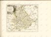

12. Wiek a/R., uit: Topographische Uebersichtskarte des Deutschen Reiches / herausgegeben v. d. Kartogr. Abt. d. Königl. Preuß. Landesaufnahme
1 : 200000 titelvariant: Topogr. Übersichtskarte des Deutschen Reiches; Annotatie: Titel boven bladen ook: Topogr. Übersichtskarte des Deutschen Reiches; Annotatie geografische gegevens: Op elk blad twee maatstokken: 10 Kilometer = 5,5 cm; 1 geogr. Meile = 3,6 cm; Legenda onder op elk blad Königlich Preußische Landesaufnahme. Kartographische Abtheilung [S.l : Königlich Preußische Landesaufnahme, Kartographische Abtheilung]
Meßtischblatt 1543 : Pramort, 1933
1 : 250000 Pramort. - Hrsg. 1885, bericht. 1925. - 1:25000. - [Berlin]: Reichsamt für Landesaufnahme, 1933. - 1 Kt.
Meßtischblatt 371, neue Nr. 1643 : Niepars, 1936
1 : 250000 Niepars. - Hrsg. 1885, bericht. 1925. - 1:25000. - [Berlin]: Reichsamt für Landesaufnahme, 1936. - 1 Kt.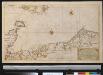
Nieuwe afteekening van een gedeelte van de Belt Zee vervattende de zeekusten van Holsteijn en Mekelenburg van het eijlant Femeren tot aan Mardorp in Pomeren
Germany Johannes van Keulen
26. Stralsund, uit: Topographische Uebersichtskarte des Deutschen Reiches / herausgegeben v. d. Kartogr. Abt. d. Königl. Preuß. Landesaufnahme
1 : 200000 titelvariant: Topogr. Übersichtskarte des Deutschen Reiches; Annotatie: Titel boven bladen ook: Topogr. Übersichtskarte des Deutschen Reiches; Annotatie geografische gegevens: Op elk blad twee maatstokken: 10 Kilometer = 5,5 cm; 1 geogr. Meile = 3,6 cm; Legenda onder op elk blad Königlich Preußische Landesaufnahme. Kartographische Abtheilung [S.l : Königlich Preußische Landesaufnahme, Kartographische Abtheilung]
Mecklenburg.
1 : 595000 Flemming, Carl
Sect. 2: Stralsund, uit: Geologische Karte des Deutschen Reichs in 27 Blaettern / [von] Richard Lepsius ; Red. von C. Vogel
1 : 500000 Annotatie: Blad 18 ontbreekt; Een aantal bladen op linnen; Een aantal bladen gereviseerd 1913-1914; Annotatie geografische gegevens: Met schaalstokken o.a. in kilometers; Legenda Carl Vogel 1828-1897 Gotha : Justus Perthes
Ducatus Meklenburgicus
1 : 460000 Mollova mapová sbírka Ottens, Reinier Ottens, Josua
Ducatus Meklenburgicus
1 : 460000 Mollova mapová sbírka Wit, Frederik de Covens, Johannes I