Maps of gmina Krokowa

Composite: 26. Ossecken. (Germany)
1 : 100000 Reichsamt fur Landesaufnahme
Messtischblatt 136 : Dembek, 1926 Dembeck
1 : 250000 Dembeck. - Aufn. 1875, einz. Nachtr. 1926. - 1:25000. - [Berlin]: Reichsamt für Landesaufnahme, 1926. - 1 Kt.
Messtischblatt 137 : Ostrau, 1877 Ostrau
1 : 250000 Ostrau. - Aufn. 1875. - 1:25000. - [Berlin]: Reichsamt für Landesaufnahme, 1877. - 1 Kt.
Messtischblatt 135 : Wittenberg, 1928 Wittenberg i. Pommern
1 : 250000 Wittenberg i. Pommern. - Hrsg. 1877, einz. Nachtr. 1928. - 1:25000. - [Berlin]: Reichsamt für Landesaufnahme, 1928. - 1 Kt.
Meßtischblatt 176 : Mechau, 1890
1 : 250000 Mechau. - Aufn. 1875, einz. Nachtr. 1890. - 1:25000. - [Berlin]: Reichsamt für Landesaufnahme, 1890. - 1 Kt.
27. Schwarzau. (Germany)
1 : 100000 Reichsamt fur Landesaufnahme
Composite: 27. Schwarzau. (Germany)
1 : 100000 Reichsamt fur Landesaufnahme
Hela 16, uit: Special-Karte von Mittel-Europa / nach amtlichen Quellen bearbeitet von W. Liebenow
1 : 300000 titelvariant: W. Liebenow's Mittel-Europa; Annotatie: Titel boven de bladen: W. Liebenow's Mittel-Europa Johannes Wilhelm Liebenow 1822-1897 Frankfurt a. M. : Ludwig Ravenstein
15. Lauenburg i. Pom., uit: Topographische Uebersichtskarte des Deutschen Reiches / herausgegeben v. d. Kartogr. Abt. d. Königl. Preuß. Landesaufnahme
1 : 200000 titelvariant: Topogr. Übersichtskarte des Deutschen Reiches; Annotatie: Titel boven bladen ook: Topogr. Übersichtskarte des Deutschen Reiches; Annotatie geografische gegevens: Op elk blad twee maatstokken: 10 Kilometer = 5,5 cm; 1 geogr. Meile = 3,6 cm; Legenda onder op elk blad Königlich Preußische Landesaufnahme. Kartographische Abtheilung [S.l : Königlich Preußische Landesaufnahme, Kartographische Abtheilung]
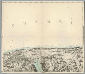
Messtischblatt 1176 : Rixhöft, 1938 Rixhöft
1 : 250000 Rixhöft. - Aufn. 1908, letzt. Nachtr. 1938. - 1:25000. - [Berlin]: Reichsamt für Landesaufnahme, 1908. - 1 Kt.
Svobodné město Gdansk (Danzig)
1 : 300000 Gdaňsk-oblast (Polsko) Jordán, V. O. Girgal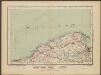
Danzig
1 : 600000 Opitz, Carl Solbrig
Sect. 4: Danzig, uit: Geologische Karte des Deutschen Reichs in 27 Blaettern / [von] Richard Lepsius ; Red. von C. Vogel
1 : 500000 Annotatie: Blad 18 ontbreekt; Een aantal bladen op linnen; Een aantal bladen gereviseerd 1913-1914; Annotatie geografische gegevens: Met schaalstokken o.a. in kilometers; Legenda Carl Vogel 1828-1897 Gotha : Justus Perthes
Provinz Westpreussen
1 : 472000 Gdaňsk (Polsko) Handtke, Friedrich Carl Flemming
Prvssia
1 Karte : Kupferdruck ; 35 x 47 cm Mercator; Hondius Henricus Hondius

West Preussen.
1 : 940000 Flemming, Carl
Regnum Borussiae gloriosis auspiciis serenissimi et potentissimi princip. Friderici III primi Borussiae regis march. et elect. Brandenburg inauguratum die 18 Jan A 1701
1 : 760000 Prusko Homann, Johann Baptist J.B. Homann
REGNUM BORUSSIAE Gloriosis auspiciis Serenissimi et Potentissimi Pri. FRIDERICI III PRIMI BORUSSIAE REGIS, MARCH. ET ELECT. BRAN. inauguratum die 18. Ian A. 1701 Geographice cum vicinis Regionibus adumbratum
1 : 750000 Prusko Homann, Johann Baptist a Ioh. Baptista Homanno
Regnum Borussiae gloriosis auspiciis serenissimi et potentissimi prin Friderici III primi Borussiae regis, march. et elect. Brandenburg inauguratum die 18. Ian A. 1701
1 : 760000 Prusko Homann, Johann Baptist a Ioh Baptista Homanno
Regnum Borussiae gloriosis auspiciis serenissimi et potentissimi prin Friderici III primi Borussiae regis, march. et elect. Bran inauguratum die 18. Ian. A. 1701
1 : 760000 Prusko Homann, Johann Baptist a Ioh. Baptista Homanno
Regnum Borussiae gloriosis auspiciis serenissimi et potentissimi princ. Friderici III primi Borussiae regis, march. et elect. Brand. inauguratum die 18. Ian. A. 1701
1 : 760000 Prusko Homann, Johann Baptist a Ioh. Baptista Homanno
Regnum Borussiae gloriosis auspiciis serenissimi et potentissimi prin Friderici III primi Borussiae regis, march. et elect. Bran inauguratum die 18. Ian. A. 1701
1 : 760000 Prusko Homann, Johann Baptist a Ioh. Baptista Homanno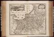
Tabula Prussiae eximia cura conscripta / per Casparum Henneberch Erlichensem et denuo edita per Nicolaum Iohannidem Piscatorem ; A. Goos sculpsit
1 : 720000 Annotatie: Origineel is Blad 93 in atlas factice; Annotatie geografische gegevens: Bevat 3 schaalstokken: Milliaria parva, Milliaria mediocria, Milliaria magna; Inzet: stadsgezicht van Konigsberg Caspar Henneberger 1529-1600; Abraham Goos ca. 1589/90-1643 [Amstelodami] : [Nicolaes Jansz. Visscher]
Prvssiae descriptio
1 Karte : Kupferdruck ; 30 x 20 cm Zell; Ortelius s.n.
Borussiae regnum
1 : 732600 Neuchâtel (Švýcarsko) Seutter, Matthäus sumtibus Matth. Seuteri
Magnae Prussiae ducatus tabula
1 : 711000 Prusko Visscher, Nicolaus per Nicolaum Visscher
PRVSSIA
ACCVRATE DESCRIPTA | a Gasparo Henneberg | Erlichensi. Excud. Guiljelmus Janß. Cæsius.
Regni prussici accuratissima delineatio
1 : 600000 edita studio opera P. Schenk [...] Amstelodami : P. Schenk