Maps of Tønder Municipality

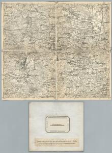
12. Lugumkloster. (Germany)
1 : 100000 Reichsamt fur Landesaufnahme
Composite: 12. Lugumkloster. (Germany)
1 : 100000 Reichsamt fur Landesaufnahme
Meßtischblatt 54 : Toftlund, 1880
1 : 250000 Toftlund. - Aufn. 1878. - 1:25000. - [Berlin]: Reichsamt für Landesaufnahme, 1880. - 1 Kt.
Meßtischblatt 53 : Arrild, 1880
1 : 250000 Arrild. - Aufn. 1878. - 1:25000. - [Berlin]: Reichsamt für Landesaufnahme, 1880. - 1 Kt.
Meßtischblatt 74 : Bedstedt, 1880
1 : 250000 Bedstedt. - Aufn. 1878. - 1:25000. - [Berlin]: Reichsamt für Landesaufnahme, 1880. - 1 Kt.
Meßtischblatt 73 : Lügumkloster, 1880
1 : 250000 Lügumkloster. - Aufn. 1878. - 1:25000. - [Berlin]: Reichsamt für Landesaufnahme, 1880. - 1 Kt.
Meßtischblatt 55 : Rauberg, 1880
1 : 250000 Rauberg. - Aufn. 1878. - 1:25000. - [Berlin]: Reichsamt für Landesaufnahme, 1880. - 1 Kt.
Meßtischblatt 75 : Jordkirch, 1880
1 : 250000 Jordkirch. - Aufn. 1878. - 1:25000. - [Berlin]: Reichsamt für Landesaufnahme, 1880. - 1 Kt.
Meßtischblatt 35 : Spandet, 1880
1 : 250000 Spandet. - Aufn. 1878. - 1:25000. - [Berlin]: Reichsamt für Landesaufnahme, 1880. - 1 Kt.
Meßtischblatt 36 : Gramm, 1880
1 : 250000 Gramm. - Aufn. 1878. - 1:25000. - [Berlin]: Reichsamt für Landesaufnahme, 1880. - 1 Kt.
3. Lügumkloster, uit: Topographische Uebersichtskarte des Deutschen Reiches / herausgegeben v. d. Kartogr. Abt. d. Königl. Preuß. Landesaufnahme
1 : 200000 titelvariant: Topogr. Übersichtskarte des Deutschen Reiches; Annotatie: Titel boven bladen ook: Topogr. Übersichtskarte des Deutschen Reiches; Annotatie geografische gegevens: Op elk blad twee maatstokken: 10 Kilometer = 5,5 cm; 1 geogr. Meile = 3,6 cm; Legenda onder op elk blad Königlich Preußische Landesaufnahme. Kartographische Abtheilung [S.l : Königlich Preußische Landesaufnahme, Kartographische Abtheilung]
PARS OCCIDENTALIS | PRÆFECTVRÆ | HADERSLEBEN | cum adjacentibus | RIPEN et LOHMCLOSTER | PRÆFECTVRIS.
Matthias Vnd Clauss Petersen | Goldtschmide gebr. Husumens. sculps. [Amsterdam : Joan Blaeu]
DVCATVS | SLESWICI | PARS BOREALIS.
Matthias und Nicolaus Pet. | Goldtschmide gebr. Hus. sculp. [Amsterdam : Joan Blaeu]
Praefectvra Apenrade et Luntoft herde
1 : 95000 Mollova mapová sbírka Mejer, Johannes Rothgiesser, Christian Lorenzen Blaeu, Joan I.
PARS ORIENTALIS | PRÆFECTVRÆ | HADERSLEBEN | Vulgo dictæ Baringsijßel.
Matthias Vnd Clauss Petersen | G.S. gebr. | Husumenss. sculps. [Amsterdam : Joan Blaeu]
PRÆFECTVRA | APENRADE | et Luntoft herde.
Christian Rothgiesser | Husum. sculpsit. [Amsterdam : Joan Blaeu]
PRÆFECTVRA | TONDERN | sine Lundtofft Herde | Anno 1648
Christian Rothgießer | Husum. sculps. [Amsterdam : Joan Blaeu]
Geologische Karte der Insel Sylt und ihrer nächsten Umgebungen / geologisch bearb. durch L. Meyn
1 : 100000 Annotatie: Geeft ook waterdiepten en stroomrichtingen aan; Met aantekening in potlood boven de titel Berlin : [Königl. Preussische geologische Landesanstalt]
Meßtischblatt 37 : Skrydstrup, 1880
1 : 250000 Skrydstrup. - Aufn. 1878. - 1:25000. - [Berlin]: Reichsamt für Landesaufnahme, 1880. - 1 Kt.
Meßtischblatt 52 : Bröns, 1919
1 : 250000 Bröns. - Aufn. 1878, hrsg. 1880, Nachtr. 1919. - 1:25000. - [Berlin]: Reichsamt für Landesaufnahme, 1919. - 1 Kt.
Ducatus Slesvicensis Pars Septentrionalis. [Karte], in: Novus atlas absolutissimus, Bd. 1, S. 158.
1 Karte aus Atlas Janssonius Offizin
[left] FRISIA BOREALIS | IN DVCATV SLESWICENSI | sive FRISIA CIMBRICA | Anno 1651. [right] FRISIA BOREALIS | IN DVCATV SLESWICENSI | Anno 1240. | Frisia Cimbrica Antiqua.
Matthias & Nicolao Peters | Goldtschmide gbr. Husum. sculps. [Amsterdam : Joan Blaeu]
Das Herzongthum Schleswig

Schleswig.
1 : 427000 Gotthard, A.
Herzogthum Schleswig
Grosser Hand-Atlas über alle Theile der Erde in 170 Karten Meyer, J. Verlag des Bibliographischen Instituts
Ducatus Slesvicensis
1 : 312700 Šlesvicko Homann, Johann Baptist a Ioh. Baptista Homan[n]o
DUCATUS SLESVICENSIS juxta novißimam et accuratißimam Designationem
1 : 325000 Šlesvicko Seutter, Matthäus sumtibus Matth. Seutteri

Fiona vulgo Funen [Karte], in: Theatrum orbis terrarum, sive, Atlas novus, Bd. 1, S. 50.
1 Karte aus Atlas Blaeu, Joan Blaeu, Willem Janszoon