Maps of Mexico
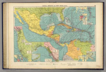
Cent. Amer., W.I. ports
1 : 10000000 Philip, George
Amérique Septentrionale publiée sous les auspices de Monseigneur le Duc d'Orleans prémier prince du sang / par le Sr. D'Anville.
from Charts and maps
A new mapp of the Empire of Mexico describing the continent to the Istmus of Panama : together with all the islands in the North Sea / F. Lamb sculp.
from Charts and maps
Mexique, Amerique Centrale et Antilles.
1 : 13000000 Migeon, J.
Mexique, Amerique Centrale, les Antilles.
1 : 11000000 Garnier, F. A., 1803-1863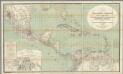
H. Kiepert's Karte des nordlichen Tropischen America.
1 : 3600000 Smith, Martin Luther, 1819-1866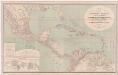
A new map of tropical-America, north of the Equator : comprising the West-Indies, Central-America, Mexico, New Cranada [sic] and Venezuela
1 : 3600000 Kiepert, Heinrich, 1818-1899 Dietrich Reimer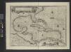
Insulae Americanae in Oceano Septentrionale.
From Whole
Map of the United States of America, the British provinces, Mexico, the West Indies and Central America, with part of New Granada and Venezuela / map drawn by Geo. W. Colton; engraved by John M. Atwood; border desig'd. & eng'd. by W.S. Barnard.
from Parts George W. Colton; John M. Atwood; W. S. Barnard,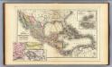
Mexico, Central America, West Indies.
1 : 12000000 Mitchell, Samuel Augustus
Cuba.
1 : 3300000 Mitchell, Samuel Augustus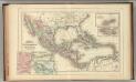
Mexico, Central America, West Indies.
1 : 12000000 Mitchell, Samuel Augustus Jr.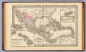
Mexico, Central America, West Indies.
1 : 12000000 Mitchell, Samuel Augustus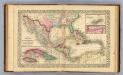
Mexico, Central America, West Indies.
1 : 12000000 Williams, W. (Wellington)
Mexico. West Indies and Central America.
1 : 7920000 Colton, G. Woolworth
Regni Mexicani seu Novae Hispaniae, Ludovicianae, N. Angliae, Carolinae, Virginiae, Pensylvaniae, ... in America Septentrionali
from John H. Levine Collection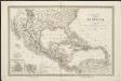
Carte du Méxique, des Antilles, d'une partie des Etats-Unis, et des pays circonvoisins
1 : 8333000 dressée d'après les nouvelles divisions, et les dernières observations par A. H. Dufour [gravée par] Guyot ; [écrite par] A. Pelicier Paris : Guyot [etc.]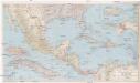
Mexico, Central America and the West Indies
1 : 5702400 Bermudy (Velká Británie : souostroví) National Geographic Society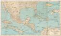
Mexico, Central America and the West Indies
1 : 5702400 Bermudy (Velká Británie : souostroví) National Geographic Society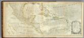
An Accurate Map Of North America. (Southern section)
1 : 5400000 Jefferys, Thomas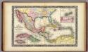
Map Of Mexico, Central America, And The West Indies.
1 : 12000000 Mitchell, Samuel Augustus
Texas, der Mexicanische Bundesstaat, der Mittelamericanische Bundesstaat, und West Indien
Schul-Atlas in 36 Karten Völter, Daniel Verlag der J.M. Dannheimer'schen Buchhandlung
Mittel-America und Westindien
Neuer Handatlas über alle Theile der Erde Kiepert, Heinrich Verlag von Dietrich Reimer
Central America, Mexico & West Indies.
1 : 14500000 Black, Adam & Charles
Mittel America.
1 : 16500000 Reichard, C. G.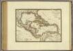
Iles-Antilles ou Indes Occidentales.
1 : 9300000 Brue, Adrien Hubert, 1786-1832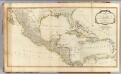
West Indies.
1 : 6400000 Robert Laurie & James Whittle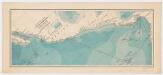
Explorations of the U. S. Fish Commission steamer Albatross : Lieut. Comdr. Z. L. Tanner U.S.N. Comdg. : Februrary to April 1891
United States Fish Commission Printed for the Museum of Comparative Zoology, Harvard University
Mexico und Centro-America
1 : 14000000 nach den besten Hülfsmitteln in Mercators Projection entworfen und gezeichnet vom Pr. L[t]. v. Stülpnagel [...] in Mercators Projection Gotha : Perthes