Maps of South America
S. Atlantic Ocean.
1 : 20000000 Philip, George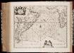
Mar di Æthiopia vulgo Oceanus Æthiopicus
1 : 22500000 Annotatie: Zeekaart; Origineel is Blad 202 in atlas factice; Annotatie geografische gegevens: Met schaalstok: Mill. Germanica Communia [Amstelodami : apud Ioannem Ianssonium]
Mar Di Aethiopia Vulgo Oceanus Aethiopicus. [Karte], in: Novus atlas absolutissimus, Bd. 9, S. 79.
1 Karte aus Atlas Janssonius Offizin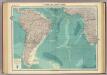
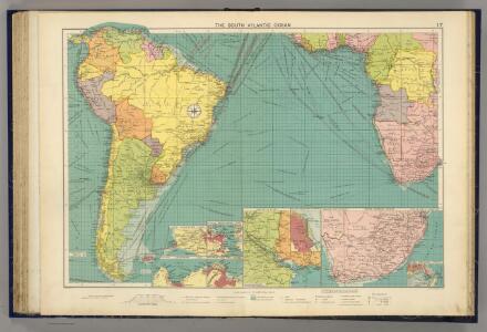
South Atlantic Ocean.
1 : 25000000 John Bartholomew & Co.
Mar Di Aethiopia Vulgo Oveanus Aethiopicus. [Karte], in: Het vijfde Deel Des Grooten Atlas : Vervatende De Water-Weereld, S. 69.
1 Karte aus Atlas Jansson, Jan Jansson, Jan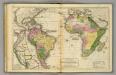
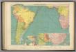
South America, Africa.
1 : 43000000 Woodbridge, William C.
Meteorological chart of the South Atlantic Ocean
1 : 20500000 Atlantský oceán (oblast) Secretary of Agriculture
Meteorological chart of the South Atlantic Ocean
1 : 20500000 Atlantský oceán (oblast) Secretary of Agriculture
Meteorological chart of the South Atlantic Ocean
1 : 20500000 Atlantský oceán (oblast) Secretary of Agriculture
Meteorological chart of the South Atlantic Ocean
1 : 20500000 Atlantský oceán (oblast) Secretary of Agriculture
Meteorological chart of the South Atlantic Ocean
1 : 20500000 Atlantský oceán (oblast) Secretary of Agriculture
Meteorological chart of the South Atlantic Ocean
1 : 20500000 Atlantský oceán (oblast) Secretary of Agriculture
Pilot chart of the South Atlantic Ocean
1 : 13000000 Atlantský oceán (oblast) Maury, Matthew Fontaine Hydrographic Office
Pilot chart of the South Atlantic Ocean
1 : 13000000 Atlantský oceán (oblast) Maury, Matthew Fontaine Hydrographic Office
Pilot chart of the South Atlantic Ocean
1 : 13000000 Atlantský oceán (oblast) Maury, Matthew Fontaine Hydrographic Office
Pilot chart of the South Atlantic Ocean
1 : 13000000 Atlantský oceán (oblast) Maury, Matthew Fontaine Hydrographic Office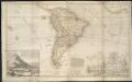
This map of South America, according to the newest and most exact observations ...
1 : 17500000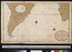
Een gedeelte van de kust van Gunea tot C. Bona Esperance, de cust van Brasielia van Parnambuco tot C. de Hoorn, als meede de kusten van Chili en Peru seer dienstig om te zijlen van C. B. Esperance tot de Straet van Magalanus
Atlantic Ocean Gerard van Keulen
Carte de l'ocean meridional
1 Karte : Kupferdruck ; 33 x 44 cm Bellin Arkstée et Merkus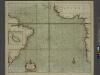
A new draught of the coast of GUINEA and BRASILE
from The sea-atlas : containing an hydrographical description of most of the sea-coasts of the known parts of the world.
CARTE DE L'OCEAN MERIDIONAL
1 : 6700000 Atlantský oceán-oblast Bellin, Jacques-Nicolas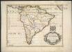
A new map of South America, shewing it's general divisions, chief cities & towns, rivers, mountains &c.
1 : 23000000
Americae pars meridionalis
Jižní Amerika Janssonius, Johannes sumptibus Ioannis Ianßony
Facsimile: Part of South America by Sanson.
1 : 26500000 Sanson D'Abbeville, N.
Composite: South America
1 : 7900000 Kitchin, Thomas
South America.
1 : 15840000 Fullarton, A. & Co.
Americae pars meridionalis
1 : 1
South America
Este mapa, sin fecha y sin autor conocido, probablemente sea de mediados del siglo XVIII. La representación de Islas Malvinas a partir del Estrecho de Falkland, como era común en la primera mitad del siglo XVIII, es un indicio en ese sentido. En enero de 1690 el inglés John Strong navegó entre las dos islas principales y llamó al paso "Falkland Channel" en honor a su mecenas el Vizconde de Falkland que como había financiado la expedición. La cartografía británica adoptaría en el siglo XVIII el nombre del canal, para designar a todo el grupo de islas, que reclamaría para Inglaterra, en contra de España. En 1740 hubo un enfrentamiento naval entre las fuerzas británicas y españolas por las islas, sin un claro vencedor. Las tensiones entre los dos imperios continuaría a lo largo del siglo XVIII.
Ethnographische Karte von Süd-Amerika
Zweiter Band, enthaltend in vier Abtheilungen die Vertheilung der Organismen: 5. Pflanzen-Geographie, 6. Thier-Geographie, 7. Anthropographie, 8. Ethnographie Humboldt, Alexander von Verlag von Justus Perthes
South America.
1 : 33000000 D.F. Robinson & Co.