Maps of British Isles
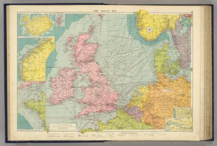
North Sea.
1 : 5000000 Philip, George
[123][126] Pascaert vande Noort-Zee om achter Yrland en Schotland om te seylen, uit: Atlas sive Descriptio terrarum orbis
Annotatie: Gedigitaliseerde versie. Amsterdam. Heiloo : Picturae (vervaardiger), 2015. tiff-bestand. Gedigitaliseerd: 07-01-2015; Origineel: Universiteitsbibliotheek Vrije Universiteit (XL.05127.-) ; Netherlands; Titelpagina ontbreekt Wit, Frederik de Amsterdam : Frederick de Wit
Mare Germanicum ac tractus maritimus retro Hiberniam et Scotiam
1 Karte : Kupferdruck ; 47 x 56 cm Renard apud L. Renard
Erdkarte zur Übersicht des Kolonialbesitzes, der konsularischen und
1 : 50000000 Kiepert, Richard ; Limpricht, Max Geographische Verlagshandlung Dietrich Reimer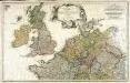
Erster Theil der Karte von Europa, welcher Frankreich, Deutschland, Italien Spanien, England, Scotland und Ireland enthælt, 1
1 Blatt : 53 x 83 cm F.A. Schrämbl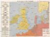
Kriegskarte der Nordsee
1 : 3350000 Severní moře-oblast Max Freissler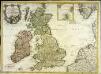
Carte des isles Britanniques contenant les royaumes d'Angleterre, d'Ecosse, d'Irlande et isles dépendantes
1 Karte : Kupferdruck ; 53 x 72 cm Flink; Mondhare chés Mondhare rue St. Jacques
British Isles - Physical Geography..
Milner, Thomas
Pas Caart van de Noort Zee .. Verthoonende in zich alle de Custen en Havens daer rontom gelegen. [Karte], in: De Nieuwe Groote Vermeerderde Zee-Atlas ofte Water-Werelt, S. 15.
1 Karte aus Atlas Doncker, Hendrick
Die Britischen Inseln und das Umliegende Meer
Handatlas über alle Theile der Erde und über das Weltgebäude Stieler, Adolf Justus Perthes
Carte des places fortes et des principaux ports des isles britanniques et des etats d'Hanovre
1 Karte : Kupferdruck ; 48 x 60 cm Brion de la Tour; Longchamps chés le Sr. Longchamps géographe rue St. Jacques à l'enseigne de la place des Victoires
Westeuropa 1935
Westeuropa Kunz, Andreas ; Treiling, Thomas
England und die Nordseeländer
1 : 3500000 Severní moře (oblast) Kartogr. Anst. Freytag & Berndt
Prima Europe Tabula [Karte], in: [Clavdii Ptholomei Cosmographi ...], S. 245.
1 Karte aus Atlas Nicolaus Germanus [und Ptolemaeus, Claudius]
Die Britischen Inseln Und Das Umliegende Meer.
1 : 3700000 Petermann, A.
Die Britischen Inseln: Volker und Sprachen.
1 : 3800000 Berghaus, Heinrich
Die Britischen Inseln und das Umliegende Meer
Hand-Atlas über alle Theile der Erde und über das Weltgebäude Stieler, Adolf Justus Perthes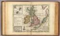
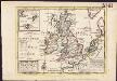
A general map of Great Britain and Ireland.
1 : 7500000 Moll, Herman, d. 1732
Tabula Europae I. [Karte], in: Geographia universalis vetus et nova complectens Claudii Ptolemaei Alexandrini enarrationis libros VIII, S. 222.
1 Karte aus Atlas Münster, Sebastian [und Ptolemaeus, Claudius]
Les isles Britanniques comprenant les royaumes d'Angleterre, Ecosse et Irlande
1 Karte : Kupferdruck ; 51 x 67 cm Crépy; Crépy chez Crepy rue S. Jacques à l'Image Saint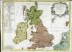
Les isles Britannicques ou sont le royaume d'Angleterre diuisé en ses quatre roy.mes des Saxons
1 Karte : Kupferdruck ; 52 x 71 cm Speed; Gordon; Pont s.n.
Die Britischen Inseln und die Nord-See
Hand-Atlas über alle Theile der Erde nach dem neuesten Zustande und über das Weltgebäude Stieler, Adolf bei Justus Perthes
Westeuropa 2003
Westeuropa Kunz, Andreas ; Treiling, Thomas
Les isles britanniques ou les royaumes d'Angleterre, d'Ecosse et d'Irlande
1 Karte : Kupferdruck ; 48 x 62 cm Le Rouge Le Rouge rue des Augustins vis a vis le panier Fleury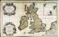
Les isles britanniques; qui contiennent les royaumes, d'Angleterre, Escosse, et Irlande
1 Karte auf 2 Blätter : Kupferdruck ; 53 x 85 cm Sanson; Jaillot; Speed; Gordon; Pont; Saxton; Camden; Boazio chez H. Iaillot joignant les grands Augustins aux deux globes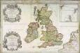
Les isles britanniques; qui contiennent les royaumes, d'Angleterre, Escosse, et Irlande
1 Karte auf 2 Blättern : Kupferdruck ; 54 x 87 cm Sanson; Jaillot; Speed; Gordon; Pont; Saxton; Camden; Boazio chez H. Iaillot joignant les grands Augustins aux deux globes
Insvlæ Albion et Hibernia
1 Karte : Kupferdruck ; 37 x 43 cm Blaeu Joan Blaeu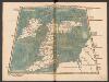
Tabula Prima Europae [Hibernia und Albion Insula Britanica] [Karte], in: Claudii Ptolemei viri Alexandrini mathematice discipline philosophi doctissimi geographie opus [...], S. 151.
1 Karte aus Atlas Waldseemüller, Martin [und Ptolemaeus, Claudius] Übelin, Georg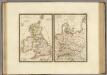
Iles Britanniques anciennes, Germanie ancienne, Rhetie, Pannonie, Norique.
1 : 3800000 Brue, Adrien Hubert, 1786-1832