Maps of England

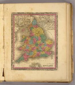
England.
1 : 2800000 Tanner, Henry S.
England and Wales.
1 : 2800000 Finley, Anthony
Le royaume d'Angleterre
1 Karte : Kupferdruck ; 55 x 47 cm Le Rouge; Basset; Basset chez Basset rue St. Jacques
Le royaume d'Angleterre
1 Karte : Kupferdruck ; 55 x 47 cm Le Rouge; Basset; Basset chez Basset rue St. Jacques
Britanniæ sive Angliæ regnum
1 Karte : Kupferdruck ; 56 x 48 cm Lotter Tobias Konrad Lotter
Le royaume d'Angleterre
1 Karte : Kupferdruck ; 55 x 47 cm Le Rouge Georges Louis Le Rouge rue des Augustins
Britanniæ sive Angliæ regnum
1 Karte : Kupferdruck ; 56 x 48 cm Seutter Matthäus Seutter
Anglia Cambdeni
1 Karte : Kupferdruck ; 38 x 32 cm Camden; Weigel; Kauffer Christoph Weigel
Magnæ Britanniae pars meridionalis, in qua regnum Angliæ
1 Karte : Kupferdruck ; 55 x 47 cm Homann; Visscher Johann Baptist Homann
Nouvelle carte de l'Angleterre
1 Karte : Kupferdruck ; 45 x 47 cm, Gesamtgrösse 45 x 63 cm Châtelain s.n.
Anglia in septem anglo-saxonum regna
1 Karte : Kupferdruck ; 53 x 47 cm Schenk Pieter Schenk
A new mapp of the kingdome of England
1 Karte : Kupferdruck ; 57 x 50 cm printed and given out by Nicolas Visscher upon the Dam at the signe of the fisher, by Iohn Overton at the white horse without Newgate
A new mapp of the kingdome of England
1 Karte : Kupferdruck ; 57 x 50 cm printed and given out by Nicolas Visscher upon the Dam at the signe of the fisher, by Iohn Overton at the white horse without Newgate
Anglia regnum in omnes suos ducatus, comitatus, et provincias divisum
1 Karte : Kupferdruck ; 57 x 48 cm Wit Frederick de Wit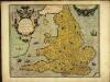
Angliæ regni florentissimi nova descriptio
1 Karte : Kupferdruck ; 38 x 45 cm Lhuyd; Ortelius s.n.
Angliæ regni florentissimi nova descriptio
1 Karte : Kupferdruck ; 38 x 45 cm Ortelius; Lhuyd s.n.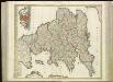
[86][86] Anglia Regnum ..., uit: Atlas sive Descriptio terrarum orbis
Annotatie: Gedigitaliseerde versie. Amsterdam. Heiloo : Picturae (vervaardiger), 2015. tiff-bestand. Gedigitaliseerd: 07-01-2015; Origineel: Universiteitsbibliotheek Vrije Universiteit (XL.05127.-) ; Netherlands; Titelpagina ontbreekt Wit, Frederik de Amsterdam : Frederick de Wit
Composite: England and Wales.
1 : 887000 Johnston, W. & A.K.
Regni Angliae et principatus Cambriae tabula nova
1 Karte : Kupferdruck ; 57 x 51 cm Kitchin; Rausch Homännische Erben
Ordnance survey physical map of Englad and Wales
1 : 1071000 Anglie Ordnance Survey Office
England and wales.
1 : 13000000 Colton, G.W.
England and Wales.
1 : 1450000 Johnson, A.J.
Accuratissima Angliæ regni et Walliæ principatus descriptio
1 Karte : Kupferdruck ; 57 x 47 cm Wit ex officina I. Cóvens et C. Mortier
Accuratissima Angliæ regni et Walliæ principatus descriptio
1 Karte : Kupferdruck ; 57 x 47 cm Wit Frederick de Wit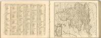

Anglia in septem Anglo-Saxonum regna omnesque hodiernas regiones ordine distincta
1 : 1400000 ededit Petrus Schenk [Amsterdam : Petrus Schenk]
Britanniae sive Angliae Regnum, tam secundum prisca Anglo-Saxonum Imperia, quam recentiorem Provinciarum divisionem accuratissime designatum
1 : 1300000 studio et sumptibus Tob. Conradi Lotter, Chalgogr. et Geogr. Augustani. [Augsburg] : [Tob. Conrad. Lotter]
England And Wales.
1 : 2850000 Finley, Anthony
England and Wales.
1 : 1450000 Johnson, A.J.