Maps of Peary Land
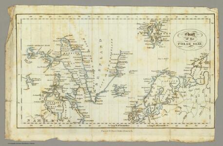
Chart, Polar Seas.
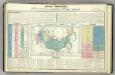
1 : 85000000 King, G. B.
North America polar regions : Baffin Bay to Lincoln Sea showing the most recent discoveries including those of U.S.S. Polaris Expedition in 1871-2, under Captain C.F. Hall, British Arctic Expedition in 1875-6, under Captain G.S. Nares, R.N., The Lady Franklin Bay Expedition in 1881-4, under Lieutenant A.W. Greely, U.S.A
1 : 1500000 United States. Hydrographic Office Hydrographic Office, Navy Dept.
Předběžná mapa skupiny ostrovů, známé pod názvem Země Františka Josefa
1 : 5000000 arktická oblast Nansen, Fridtjof Jackson, Frederick George nákladem J. Otty
Carte des glaces boreales.
1 : 34000000 Vincent
Fysikální mapa severních polárních zemí
1 : 14000000 Arktida Bartholomew, J. G. Nansen, Fridtjof nákladem J. Otty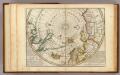
Map of the North Pole and territories near it.
1 : 26000000 Moll, Herman, d. 1732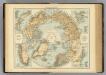
N. Polar Regions.
1 : 20000000 Andree, Richard; Times (London, England)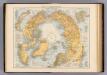
Nordpolarregion.
1 : 20000000 Andree, Richard
Nordpolargebiete
1 : 20000000 Arktida Velhagen & Klasing
Physical map of the Arctic
1 : 20000000 Arktida American geographical society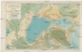
Bathymetric map of the Arctic basin
1 : 20000000 Severní ledový oceán Nansen, Fridtjof American geographical society
Nord-Polar-Karte
1 : 20000000 Arktida Berghaus, Heinrich Karl Wilhelm Habenicht, Hermann Justus Perthes
Nansen's Nordpolfahrt 1893-1896
1 : 30000000 Arktida Umlauft, Friedrich Kartogr. Anstalt von G. Freytag & Berndt
Carta delle Terre polari Artiche
1 : 11800000 Arktida Miniscalchi-Erizzo, Francesco P. Ripamonti Carpano
Essai d'une carte polaire arctique
1 Karte : Kupferdruck ; Durchmesser 46 cm Robert de Vaugondy; Dussy chés l'auteur quai de l'horloge du Palais près le Pont neuf
[140][143] Poli Arctici ..., uit: Atlas sive Descriptio terrarum orbis
Annotatie: Gedigitaliseerde versie. Amsterdam. Heiloo : Picturae (vervaardiger), 2015. tiff-bestand. Gedigitaliseerd: 07-01-2015; Origineel: Universiteitsbibliotheek Vrije Universiteit (XL.05127.-) ; Netherlands; Titelpagina ontbreekt Wit, Frederik de Amsterdam : Frederick de Wit
Nova Et Accurata Poli Arctici et terrarum Circum Iacentium Descriptio. [Karte], in: Novus atlas absolutissimus, Bd. 9, S. 55.
1 Karte aus Atlas Janssonius Offizin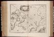
Regiones svb polo arctico / auctore Guiljelmo Blaeu
1 : 13500000 Annotatie: Met wapen; Met opdracht van Joh. Blaeu aan Guilielmus Backer de Corneliis; Origineel is Blad 147 in atlas factice; Annotatie geografische gegevens: Met 3 schaalstokken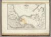
Amerique Boreale.
1 : 12000000 Montemont, A.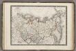
Siberie ou Russie d'Asie.
1 : 18000000 Monin, C.V.
Amerique Russe, regions polaires boreales.
1 : 13000000 Garnier, F. A., 1803-1863
Scandinavia, comprehending Norway, Sueden, and part of Denmark.
from New & accurate description of the earth in all its empires, kingdoms and states
Russia in Asia.
1 : 19800000 Tanner, Henry S.
Sibérie ou Russie d'Asie / par C.V. Monin
1 : 18000000 1 Karte : Kupferdruck ; 26 x 38 cm Monin, Charles V. [Perisse Frères]
REGIONES | SVB POLO ARCTICO
Auctore Guiljelmo Blaeu [Amsterdam : Joan Blaeu]
Northern Asia - Asiatic Russia.
1 : 16600000 Sharpe, J.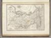
Asie Boreale.
1 : 16500000 Montemont, A.
Arctic Regions.
Fullarton, A. & Co.
Russian Empire.
1 : 27500000 Lucas, Fielding Jr.