Maps of Transantarctic Mountains

Terres Australes.
1 : 60000000 L'Isle, Guillaume de, 1675-1726
Sudpolarregion, Polynesische Inselgruppen.
Andree, Richard
Sud-Polar-Karte. (Maasfstab 1:40,000,000).
1 : 40000000 Petermann, A.
Sud-Pol.
1 : 50000000 Meyer, Joseph, 1796-1856
South Polar regions.
1 : 14000000 John Bartholomew and Son
Southern Regions.
1 : 22176000 Colton, G.W.
Süd-Polar-Karte
1 : 40000000 Antarktida Petermann, August Habenicht, Hermann Justus Perthes
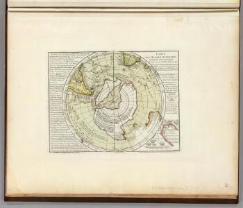
Carte des terres australes, comprises entre le tropique du Capricorne et le pôle antarctique
1 Karte : Kupferdruck ; Durchmesser 24 cm, Blattgrösse 47 x 62 cm Buache; Bouvet de Lozier; Delahaye Philippe Buache
[Südpolgebiet]
1 Karte : Kupferdruck ; Durchmesser 42 cm, Bildgrösse 43 x 49 cm Valck; Schenk apud G Valk et P Schenk
[Südpolgebiet]
1 Karte : Kupferdruck ; Durchmesser 42 cm, Bildgrösse 43 x 48 cm Blaeu s.n.
Carta generale del Polo Antartica
1 : 22500000 Marzolla, Benedetto
Facies Poli Antarctici
1 : 34000000 Antarktida Weigel, Christoph
Chica sive Patagonica et avstralis terra
1 Karte : Kupferdruck ; Bildgrösse 22 x 28 cm Quad Johannes Bussemacher
Antarctic Ocean (1901)
Antarctic Ocean. Sheet VIII. Shewing Tracks and Discoveries of H.M.S. Erebus and Terror" 1841-42. With Tracks and amendments ... to 1900." London : Admiralty
Chart of the Antarctic Continent.
1 : 11100000 Wilkes, Charles, 1798-1877
New Zealand.
1 : 2534400 Stanford, Edward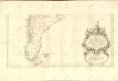
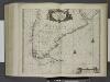
Paskaarte van het zuydelijckste van America, van Rio de la Plata tot Caap de Hoorn, ende inde Zuyd Zee, tot B. de Koquimbo.
from De zee-atlas ofte water-wereld : waer in vertoont werden alle de zee-kusten van het bekende des aerd-bodems : seer dienstigh voor alle heeren en kooplieden, als oock voor alle schippers en stuurlieden / by Pieter Goos.
Patagonia, Feuerland, Falklands, Antarctische Continent.
1 : 7700000 Radefeld, Carl Christian Franz, 1788-1874
South America 6.
1 : 6969600 Letts, Son & Co.
S. extremity of America.
1 : 4500000 Cook, James, 1728-1779
Composite: (Mapa de la Republica de Chile 9-15)
1 : 11000000 Pissis, Aime, 1812-1889
Bunnen av Weddell Havet
1 : 2700000 Antarktický oceán Norges geogr. opmaling
Tabula Magellanica, quâ Tierrae del fuego [...] [Karte], in: Theatrum orbis terrarum, sive, Atlas novus, Bd. 2, S. 359.
1 Karte aus Atlas Blaeu, Joan Blaeu, Willem Janszoon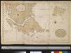
Verbeeterde caert van de uijthoek van Zuijd America waer in vervat sijn de onlangs ondekte eijlanden, door de scheepen van St. Malo, zedert den jaaren 1700, welker west sijde nog onbekent is, de doortogt, die hier met de naam van St. Barbara genaemt word is, onlangs den 25 Maij 1713 ontdeckt door een schip t welk dien naam hadt
Chile Gerard van Keulen
Tabula Magellanica, quâ Tierrae del Fuego [...] [Karte], in: Le théâtre du monde, ou, Nouvel atlas contenant les chartes et descriptions de tous les païs de la terre, Bd. 2, S. 344.
1 Karte aus Atlas Blaeu, Willem Janszoon und Blaeu, Joan Blaeu, Willem Janszoon
TABVLA MAGELLANICA, | quâ Tierræ del fuego, cum celeberrimis fretis a | F. Magellano et I. Le Maire detectis novissima et | accuratissima descriptio exhibetur.
[Amsterdam : Joan Blaeu]
Tabula Magellanica, Qua Tierrae Del Fuego [...] [Karte], in: Novus atlas absolutissimus, Bd. 6, S. 252.
1 Karte aus Atlas Janssonius Offizin
Extrémité méridionale de l'Amérique
Jižní Amerika Bonne, Rigobert André