Maps of Montbéliard
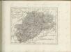
145 Vesoul.
1 : 86400 Cassini family; Cassini, Cesar-Francois, 1714-1784
[Vesoul]
1 Blatt : 61 x 92 cm Durand s.n.
Carte du district de Montbeliard et terres limitrophes
1 Karte : Kupferdruck ; 52 x 45 cm Weis s.n.
Carte topographique des limites d'une partie de la principauté le l'Lveche de Bâle centre les terre de France, conformément au Traitté d'Echange, arretté entre Sa Majesté tres chretienne et Son Altesse le prince-eveque de Bâle le 20. juin, ratifié le 11 juillet 1780
1 : 75000 Alsasko (Francie)
Carte du comté de Montbeliard et terres limitrophes
1 : 65000 Montbéliard (Francie) Weis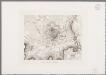
[Vesoul et environs]
1 : 20000 Annotatie: Herdruk van originele koperplaat; Oorspr. uitg.: ca. 1850 [Paris : I.G.N.]
[Kaart], uit: Plan de Besançon : avec notice historique et guide pour la visite de la ville et des environs
1 : 8000 Annotatie geografische gegevens: Water blauw Besançon : Girardot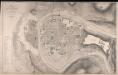
Plan De La Ville De Besançon
1 : 3000 Kirwan, J. J. Lemercier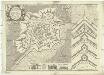
Besfort
1 : 2800 Belfort (Francie) Du Chaffat, Antoine par du Chaffat
Carte topographique des environs de Porrentruy
1 : 20000 Froté, Eugène ; Michel, Victor ; Thurmann, Jules Victor Michel
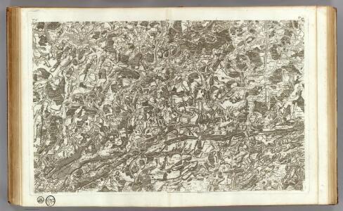
Meßtischblatt 3692/3696 : Friesen, 1914
1 : 250000 Friesen. - Aufn. 1885, hrsg. 1886, B. 08, N. 13, Aufldr. 1914. - 1:25000. - [Berlin]: Reichsamt für Landesaufnahme, 1914. - 1 Kt.
Sequani
1 Karte : Kupferdruck ; 39 x 47 cm Sanson; Robert de Vaugondy; Somer chez le Sr. Robert geographe ordin. du roy quai de l'Horloge du Palais
Schulwandkarte zur Geschichte der Schweiz
1 : 180000 Nordwest-Blatt Oechsli, Wilhelm ; Baldamus, Alfred Kartograph. Verlagsanstalt von Georg Lang
Distanzenkarte von der Schweiz
1 : 200000 1 Karte in 8 Teilen nach den besten Hülfsquellen bearb. von R. Huber Wagner, Bern
Wandkarte der Schweiz
1 : 200000 1 Karte auf 8 Blättern J.M. Ziegler Wurster, Winterthur
Besançon
1 : 200000 1 Karte entworfen und bearbeitet von Woerl ; in Stein gestochen unter seiner Leitung 1835 ; Lithographie von B. Herder Herder, Freiburg im Breisgau
Département du Doubs
1 : 260000 Doubs (Francie : departmán) Houdan, François d' P. G. Chanlaire
Sequani Partie des Archidconnes de Favernay et de Luxeuil du Dioecese de Besancon
1 : 240000 Mollova mapová sbírka Sanson, Nicolas Somer, Jean Pruthenus Sanson, Nicolas
Département de la Haute Saone
1 : 260000 Haute-Saône (Francie) Chanlaire, Pierre-Grégoire P.G. Chanlaire
Département du Doubs
1 Karte : Kupferdruck ; 39 x 34 cm Capitaine s.n.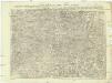
Carte topographique d'Allemagne
1 : 224000 Alsasko (Francie) Jaeger, Johann Wilhelm Abraham I.W.A. Iaeger
Carte topographique d'Allemagne
1 : 224000 Alsasko (Francie) Jaeger, Johann Wilhelm Abraham I. W. A. Iaeger
Basel 154, uit: [W. Liebenow's Special-Karte von Mittel-Europa]
1 : 300000 titelvariant: W. Liebenow's Mittel-Europa; Annotatie: Titel boven de bladen: W. Liebenow's Mittel-Europa Johannes Wilhelm Liebenow 1822-1897 Hannover : Hermann Oppermann
[Atlas départemental : La France et ses colonies] No. 24 Doubs
1 : 670000 publ. par Michel fils ainé [dressé par A. Lorrain, et gravé par H. Dandeleux] Versailles [etc.] : Barreswil et Andrieux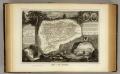
Dept. Du Doubs.
1 : 571000 Levasseur, Victor.
Département de la Haute Saone
1 : 260000 Haute-Saône (Francie) Houdan, d' P. G. Chanlaire et Dumez
Département de la Haute Saone
1 Karte : Kupferdruck ; 48 x 48 cm Houdan; Dumez chez Dumez directeur de l'Atlas national rue de la Harpe no. 26
Partie septentrionale du comté de Bourgogne ou Franche-Comté
1 Karte : Kupferdruck ; 46 x 55 cm Robert de Vaugondy; Gobin G. et D. Robert de Vaugondy