Maps of Bourges
10 Bourges.
1 : 86400 Cassini family; Cassini, Cesar-Francois, 1714-1784
[Bourges]
1 Blatt : 60 x 91 cm Le Roy s.n.
Govvernement de Bourges
1 Karte : Kupferdruck ; 11 x 15 cm Sebastian Cramoisy
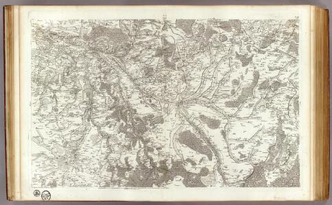
30 Loches.
1 : 86400 Cassini family; Cassini, Cesar-Francois, 1714-1784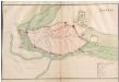
Bourges
A colored manuscript plan of the fortifications of the town of Bourges, France; drawn about 1650.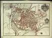
Plan de la ville et des fauxbourgs de Bourges capitale de la province de Berri
1 Plan : Kupferdruck ; 23 x 33 cm Fer Nicolas de Fer
Département du Cher
1 : 265000 Cher (Francie) Houdan, François d' P. G. Chanlaire et Dumez

Dept. De Cher.
1 : 563000 Levasseur, Victor.
Département du Cher
1 Karte : Kupferdruck ; 41 x 34 cm Capitaine s.n.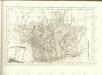

Département du Cher
1 Karte : Kupferdruck ; 56 x 40 cm Houdan; Dumez chez Dumez directeur de l'atlas national de France rue de la Harpe n.o 26
Bourges 151, uit: Special-Karte von Mittel-Europa / nach amtlichen Quellen bearbeitet von W. Liebenow
1 : 300000 titelvariant: W. Liebenow's Mittel-Europa; Annotatie: Titel boven de bladen: W. Liebenow's Mittel-Europa Johannes Wilhelm Liebenow 1822-1897 Frankfurt a. M. : Ludwig Ravenstein
Diocese de l'archevesche de Bourges
1 : 211000
Bourges 151, uit: [W. Liebenow's Special-Karte von Mittel-Europa]
1 : 300000 titelvariant: W. Liebenow's Mittel-Europa; Annotatie: Titel boven de bladen: W. Liebenow's Mittel-Europa Johannes Wilhelm Liebenow 1822-1897 Hannover : Hermann Oppermann
[Gien]
1 Blatt : 60 x 91 cm Le Roy s.n.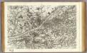
29 Blois.
1 : 86400 Cassini family; Cassini, Cesar-Francois, 1714-1784
Generalkarte von Zentraleuropa

22) VIII.N.E. ''Bourges'', uit: Carte géologique de France
1 : 500000 Annotatie: Voor aanwezige bladen zie bladoverzicht [S.l : s.n.]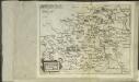
Bitvrigvs
1 Karte : Kupferdruck ; 15 x 19 cm Lambert Andreae

La generalité de Paris, 3
1 Blatt : 68 x 52 cm chez l'auteur
Regionis; Bitvrigvm exactiss: descriptio
2 Karten auf 1 Blatt : Kupferdruck ; Bildgrösse 31 x 49 cm Chaumeau; Ortelius; Simeoni s.n.
Regionis; Bitvrigvm exactiss: descriptio
2 Karten auf 1 Blatt : Kupferdruck ; Bildgrösse 31 x 49 cm Chaumeau; Ortelius; Simeoni s.n.
Gouvernement de Berry
1 Karte : Kupferdruck ; 31 x 41 cm Mentelle; Tardieu; Dubuisson Mentelle
Bitvricvm dvcatvs
1 Karte : Kupferdruck ; 35 x 46 cm Valck; Schenk apud Gerardum Valk et Petrum Schenk
Berry ducatus
1 Karte : Kupferdruck ; 32 x 41 cm Mercator; Hondius Henricus Hondius
Berry ducatus
1 Karte : Kupferdruck ; 32 x 41 cm Hondius; Mercator Jodocus Hondius
Berry ducatus
1 Karte : Kupferdruck ; 32 x 40 cm Mercator s.n.