Maps of Normandy
Composite 4: Carte de France.
1 : 86400 Cassini family; Cassini, Cesar-Francois, 1714-1784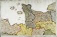
Carte de la France, no. 4
1 Blatt : 61 x 92 cm s.n.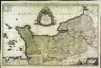
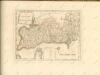
Le Duché et gouvernement de Normandie
1 Karte : Kupferdruck ; 55 x 87 cm Sanson; Jaillot chez H. Iaillot au deux Globes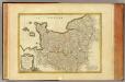
Normandie, Maine, Perche.
1 : 930000 Bonne, Rigobert, 1727-1794
Northwestern Normandy : natural regions
1 : 550000 Provisional ed. Relief shown by shading. "Map no. 2369, 8 July 1943." "Restricted." "Reliability code: 00--2B--2." United States. Office of Strategic Services. Research and Analysis Branch [Washington, D.C.] : R & A, OSS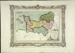
Carte des départemens de la Manche, du Calvados, de l'Orne, de l'Eure et de la Seine inférieure
1 Karte : Kupferdruck ; 22 x 32 cm, Bildgrösse 32 x 42 cm Brion de la Tour; Desnos chez le S. Desnos rue St. Jacques au globe
Li governi di Normandia del Maine, e Perche
1 Karte : Kupferdruck ; 29 x 39 cm Zatta; Zuliani presso Antonio Zatta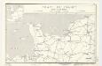
Coast of France : Dieppe to St. Brieuc
1 : 885000 Provisional ed. Inset: [Location map]. Shows main roads and railroads. Dated: 12 June 1944. United States. Office of Strategic Services. Research and Analysis Branch [Washington, D.C.] : R & A, OSS
N.W. Normandy : fisheries
1 : 880000 Provisional ed. "Map no. 2324." "19 July 1943." Includes location map. United States. Office of Strategic Services. Research and Analysis Branch [Washington, D.C.] : R & A, OSS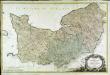
Carte de la Normandie
1 Karte auf 2 Blättern : Kupferdruck ; 62 x 96 cm Legendre; Lattré chez Lattré graveur ordinaire du roi de M. le Duc d'Orleans et de la ville rue St. Jacques a la ville de Bordeaux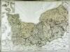
Gouvernement de Normandie
1 Karte auf 4 Blättern : Kupferdruck ; 60 x 82 cm Mentelle; Tardieu; Macquet Mentelle
Le gouvernement general de Normandie, 1
1 Blatt : chez l'auteur Jaillot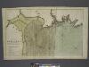
The coast of BRETAGNE from GRANVILLE to CAPEFREHEL
from The sea-atlas : containing an hydrographical description of most of the sea-coasts of the known parts of the world.
Carte de la province de Normandie, 1
1 Blatt : Esnauts et Rapilly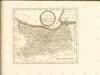
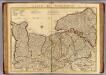
Normandie.
1 : 388000 L'Isle, Guillaume de, 1675-1726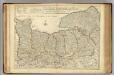
Normandie.
1 : 388000 L'Isle, Guillaume de, 1675-1726
Normannia
1 Karte : Kupferdruck ; 47 x 56 cm L'Isle Homännische Erben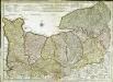
Carte de Normandie
1 Karte : Kupferdruck ; 47 x 65 cm L'Isle; Buache; Dezauche chez Dezauche graveur successeur et possesseur du fond géographique des S.rs Delisle et Buache et chargés de l'entrepo't général des cartes de la marine rue des Noyers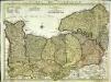
Carte de Normandie
1 Karte auf 2 Blättern : Kupferdruck ; 47 x 64 cm L'Isle; Condet chez J. Cóvens et C. Mortier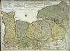
Carte de Normandie
1 Karte : Kupferdruck ; 47 x 65 cm L'Isle chez l'auteur sur le quay de l'Horloge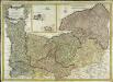
Carte de la province de Normandie
1 Karte : Kupferdruck ; 48 x 68 cm Duperrier chez l'auteur
Carte reduite des isles de Jersey, Grenesey et d'Aurigny
1 Karte : Kupferdruck ; 54 x 40 cm Bellin s.n.
NORMANNIA GALLIAE celebris Provincia in terras suas et Ballifiatus divisa
1 : 450000 Normandie (Francie) Delisle, Guillaume curantibus Homannianis Heredibus
NORMANNIA GALLIAE celebris Provincia in terras suas et Ballifiatus divisa
1 : 450000 Normandie (Francie) Delisle, Guillaume curantibus Homannianis Heredibus
France 1:250,000, Caen
Sheet 8 of the 40-sheet map series, France 1:250 000, Series GSGS 2738. Great Britain. General Staff. Geographical Section. [London] : [GSGS, War Office]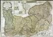
Le Duché et gouvernement de Normandie
1 Karte : Kupferdruck ; 48 x 68 cm Crépy; Crépy chez Crepy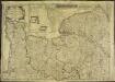
Le Duché et gouvernement de Normandie
1 Karte : Kupferdruck ; 48 x 68 cm Crépy chez Crepy