Maps of Wales

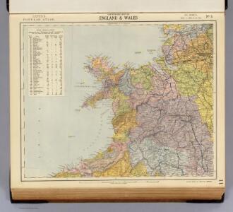
Watershed map England, Wales 3.
1 : 760320 Letts, Son & Co.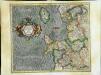
Westmorlandia, Lancastria, Cestria, Caernarvan, Denbigh, Flint, Merionidh, Montgomery, Salopia cum insulis Mania et Anglesey
1 Karte : Kupferdruck ; 34 x 40 cm Mercator; Hondius Henricus Hondius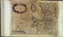
Westmorlandia, Lancastria, Cestria, Caernarvan, Denbigh, Flint, Merionidh, Montgomery, Salopia cum insulis Mania, et Anglesey
1 Karte : Kupferdruck ; 17 x 24 cm Mercator Cloppenburgh
Westmorlandia, Lancastria, Cestria, Caernarvan, Denbigh, Flint, Merionidh, Montgomery, Salopia cum insulis Mania et Anglesey
1 Karte : Kupferdruck ; 34 x 40 cm Mercator; Hondius Jodocus Hondius
Principatus Walliae Pars Borealis vulgo North Wales
1 : 390000 Amstelodami : apud Joannem Janssonium

Principatus Walliae Pars Borealis Vulgo North Wales. [Karte], in: Novus atlas absolutissimus, Bd. 8, S. 8.
1 Karte aus Atlas Janssonius Offizin
Cambriae typus
1 : 780000
England II.
1 : 765000 Society for the Diffusion of Useful Knowledge (Great Britain)
Wallia Principatus Vulgo Wales. [Karte], in: Theatrum orbis terrarum, sive, Atlas novus, Bd. 4, S. 390.
1 Karte aus Atlas Blaeu, Joan Blaeu, Willem Janszoon
CUMBRIAE TYPUS auctore HVMFREDO LHVYD, Denbigiense Cambrobritanno
This is a map of Wales by Humpfry Lyde, after Ortelius. It forms part of an atlas that belonged to William Cecil Lord Burghley, Elizabeth I’s Secretary of State. Burghley used this atlas to illustrate domestic matters. Lyde, Humpfry
Wallia Principatus Vulgo Wales. [Karte], in: Le théâtre du monde, ou, Nouvel atlas contenant les chartes et descriptions de tous les païs de la terre, Bd. 4, S. 336.
1 Karte aus Atlas Blaeu, Willem Janszoon und Blaeu, Joan Blaeu, Willem Janszoon
WALLIA | PRINCIPATVS | Vulgo WALES.
[Amsterdam : Joan Blaeu]
Wallia principatvs vulgo Wales
1 Karte : Kupferdruck ; 37 x 48 cm Blaeu Joan Blaeu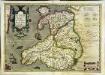
Cambriae typus
1 Karte : Kupferdruck ; 33 x 48 cm Lhuyd; Keere; Mercator; Hondius Henricus Hondius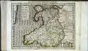
Cambriae typus
1 Karte : Kupferdruck ; 17 x 24 cm Lhuyd; Keere; Mercator Cloppenburgh
Cambriae typvs
1 Karte : Kupferdruck ; 35 x 47 cm Lhuyd; Ortelius s.n.
Cambriae typvs
1 Karte : Kupferdruck ; 35 x 47 cm Lhuyd; Ortelius s.n.
Wales.
1 : 395000 Hughes, William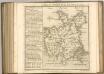

An accurate map of North Wales
1 Karte : Kupferdruck ; 50 x 66 cm Tinney; Bowles; Sayer; Bowles; Bowles printed for T. Bowles in St. Pauls Church Yard John Tinney and Rob.t Sayer in Fleet street and John Bowles and son in Cornhil
Sheet 4 North Wales, uit: Maps of England & Wales : scale 4 miles to 1 inch / Ordnance Survey
1 : 253440 titelvariant: Maps of England and Wales; Annotatie: Titel op cassette; Met bladoverzicht op de achterzijde van de cassette; Annotatie geografische gegevens: Hoogtelijneninterval 200 ft Ordnance Survey, United Kingdom Southampton : Ordnance Survey Office
63. England, North-West and Middle. The World Atlas.
1 : 500000 USSR (Union of Soviet Socialist Republics).
delineation of the strata of England and Wales, with part of Scotland
1 : 320000 Blatt 6 Smith, William Cary
Lancastria Palatinatus Anglis Lancaster et Lancas Shire. [Karte], in: Theatrum orbis terrarum, sive, Atlas novus, Bd. 4, S. 476.
1 Karte aus Atlas Blaeu, Joan Blaeu, Willem Janszoon
LANCASTRIA | PALATINATVS | Anglis | LANCASTER et | Lancas shire.
[Amsterdam : Joan Blaeu]
Lancastria Palatinatus Anglis Lancaster et Lancas Shire. [Karte], in: Theatrum orbis terrarum, sive, Atlas novus, Bd. 4, S. 476.
1 Karte aus Atlas Blaeu, Joan Blaeu, Willem Janszoon
Lancastria Palatinatus Anglis Lancaster et Lancas shire. [Karte], in: Le théâtre du monde, ou, Nouvel atlas contenant les chartes et descriptions de tous les païs de la terre, Bd. 4, S. 408.
1 Karte aus Atlas Blaeu, Willem Janszoon und Blaeu, Joan Blaeu, Willem Janszoon
delineation of the strata of England and Wales, with part of Scotland
1 : 320000 Blatt 7 Smith, William Cary