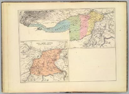
Maps of Apure
(Provincia de Apure), Canton de Caycara, Prov. de la Guyana
1 : 1300000 Codazzi, Agustin, 1793-1859
Apure.
1 : 2700000 Restrepo, Jose Manuel, 1781-1863
Partie, Colombie. Amer. Merid. 2.
1 : 1641836 Vandermaelen, Philippe, 1795-1869
Boyaca.
1 : 2700000 Restrepo, Jose Manuel, 1781-1863
(Provincias de Barquisimeto, Carabobo, Trujillo y Barinas)
1 : 1300000 Codazzi, Agustin, 1793-1859
Zulia.
1 : 2650000 Restrepo, Jose Manuel, 1781-1863
Venezuela.
1 : 2650000 Restrepo, Jose Manuel, 1781-1863
(Provincias de Maracaibo, Coro y Merida)
1 : 1300000 Codazzi, Agustin, 1793-1859
Venezuela.
1 : 3743000 Hammond, C.S.
226. Venezuela, North. The World Atlas.
1 : 3750000 USSR (Union of Soviet Socialist Republics).
Mapa de Venezuela ... guerra de independencia.
1 : 5300000 Codazzi, Agustin, 1793-1859
Venezuela, cum parte Australi Novae Andalusiae. [Karte], in: Theatrum orbis terrarum, sive, Atlas novus, Bd. 2, S. 343.
1 Karte aus Atlas Blaeu, Joan Blaeu, Willem Janszoon

Venezuela, cum parte Australi Novae Andalusiae. [Karte], in: Novus Atlas, das ist, Weltbeschreibung, Bd. 2, S. 337.
1 Karte aus Atlas Blaeu, Joan Blaeu, Willem Janszoon
Venezuela, cum parte Australi Novae Andalusiae. [Karte], in: Gerardi Mercatoris et I. Hondii Newer Atlas, oder, Grosses Weltbuch, Bd. 2, S. 401.
1 Karte aus Atlas Mercator, Gerhard und Hondius, Jodocus Jansson, Jan
Ecuador, Granada, Venezuela, Brazil, Guayana.
1 : 6900000 Society for the Diffusion of Useful Knowledge (Great Britain)
Mapa politico de Venezuela, antes 1810, 1840.
1 : 5300000 Codazzi, Agustin, 1793-1859
VENEZVELA, | cum parte Australi | NOVÆ ANDALVSIÆ
[Amsterdam : Joan Blaeu]
A Map of the British Empire in America. (Sheet 20).
1 : 2000000 Popple, Henry
Castille d' Or
“Castille D'Or”, es uno de los mapas impresos más pequeños del siglo XVII sobre los territorios de las actuales Panamá, Colombia y Venezuela. También fue uno de los que probablemente más circuló entre la población europea por ser parte de uno de los atlas de bolsillo más popular y económico de su tiempo. Duval, P. (Pierre) (1619-1683)
Coffee map of the Republic of Colombia
1 : 2750000 Federación nacional de cafeteros de Colombia Bogotá : Federation of Coffee Growers of Colombia
Terra Firma
Mapa de Tierra Firme que proviene de uno de los más raros y apetecidos atlas en miniatura del siglo XVII. El texto al inferior del mapa identifica regiones con su respectiva ciudad principal: 1) Audiencia de Panamá, Panamá. 2) Provincia de Popayán, Antequera. 3) Cartagena, Cartagena. 4) Santa Marta, Santa Marta. 5) Rio del Hacha, Rio del Hacha. 6) Venezuela, Venezuela. 7) Granada, Bogotá. 8) Paria, Tamara. 9) Nueva Andalucía, Cumaná. Müller, Johann Ulrich (1653-1715) Bodenehr, Gabriel Kühn, Georg Wilhelm (fl. 1679-1717)
Terra Firma et. Novum Regnum Granatense et. Popayan [Karte], in: Novus atlas absolutissimus, Bd. 6, S. 231.
1 Karte aus Atlas Janssonius Offizin
Mapas fisicos de Venezuela.
1 : 5300000 Codazzi, Agustin, 1793-1859
Mapa de la Republica de la Nueva Granada / por Joaquin Acosta
1 : 2700000 Annotatie: Opgedragen aan Baron von Humboldt; Met dwarsdoorsnede van de geologische structuur van de Cordillera de los Andes Acosta, Joaquin [S.l. : s.n.]
Venezuela cum parte Australi Novae Andalusiae
from America: being the latest, and most accurate description of the Nevv vvorld; containing the original of the inhabitants, and the remarkable voyages thither. The conquest of the vast empires of Mexico and Peru, and other large provinces and territories, with the several European plantations in those parts. Also their cities, fortresses, towns, temples, mountains, and rivers. Their habits, customs, manners, and religions. Their plants, beasts, birds, and serpents. With an appendix, containing, besides several other considerable additions, a brief survey of what hath been discover'd of the vnknown south-land and the Arctick region. Collected from most authentick authors, augmented with later observations, and adorn'd with maps and sculptures, by John Ogilby ...
Venezuela, cum parte Australi Novae Andalusiae. [Karte], in: Novus atlas absolutissimus, Bd. 6, S. 237.
1 Karte aus Atlas Janssonius Offizin
Der Orenoco
Orinoko-oblast (Venezulea a Kolumbie) Löwenberg, J. J. Löwenberg