Maps of Island Of Newfoundland

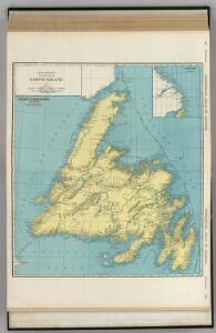
Newfoundland.
1 : 1204000 Rand McNally and Company
Newfoundland.
1 : 1584000 Stanford, Edward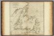
A General Chart Of The Island Of Newfoundland.
1 : 1280000 Jefferys, Thomas
Map of Newfoundland.
1 : 3900000 Morse, Jedidiah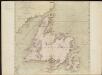
A general chart of the island of Newfoundland with the rocks & soundings
1 : 1280000
Le Isole di Terra Nuova e Capo Breton Di Nuova Projezione.
1 : 2100000 Zatta, Antonio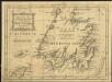
A new map of the only useful and frequented part of New Found Land
1 : 2800000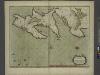
A new chart of the trading part of NEW FOUND LAND
from The sea-atlas : containing an hydrographical description of most of the sea-coasts of the known parts of the world.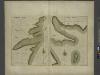
HARBOR GRACE part of new found land; BAY BULLS part of new found land
from The sea-atlas : containing an hydrographical description of most of the sea-coasts of the known parts of the world.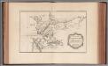
Carte des bayes, rades, et port de Plaisance dans l'isle de Terre-Neuve
1 : 61392 Bellin, Jacques Nicolas, 1703-1772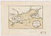
Port de Louisbourg dans l'Isle Royale
1 : 24000 Bellin, Jacques Nicolas, 1703-1772 J. N. Bellin
Carte de l'Isle St. Pierre
1 : 47323 Bellin, Jacques Nicolas, 1703-1772
A plan of the city & harbour of Louisburg, shewing that part of Gabarus Bay in which the English landed, also their encampment during the Siege in 1745
1 : 37000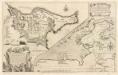
A plan of the city, and fortifications, of Louisburg
1 : 1
Plan de la ville et du port de Louisbourg levé en 1756
1 : 8000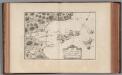
Plan de la rade et port de l'Isle St. Pierre
1 : 15348 Bellin, Jacques Nicolas, 1703-1772
Plan des fortifications de la ville de Louisbourg dans l'isle de Cap-Breton
1 : 8000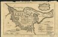
A plan of the city & fortifications of Louisburg
1 : 8500
A plan of the city and fortifications of Louisburg from a survey made by Richard Gridley, Lieut. Coll. of the train of artillery in 1745, this important fortress was taken on the 17th of June 1745 after a siege of 49 days by nine regiments (that were raised and equiped in 50 days in New England) and commanded by Sr Will.m Pepperill assisted by a fleet under the commande of Commodore Warren with the loss of 101 men killed and 30 that died by sickness. This place was afterwards restored to the French by the Treaty of Aix la Chapel ; A plan of the City and Harbour of Louisburg with the French batteries shewing that part of Gabarus Bay in which they landed and the ground on which they encamped during the Seige in 1758 [i.e. 1745].
1 : 3600 Gridley, Richard, ca. 1710-1796 Thos. Jeffrys, Geographer to the Prince of Wales at Charing Cross
A plan of the city and fortifications of Louisburg from a survey made by Richard Gridley, Lieut. Col. of the train of of artillery in 1745, this important fortress was taken on June 17th 1745 after a seige of 49 days by nine regiments that were raised & equiped in 50 days in New England and commanded by Sr. Willm. Pepperill assisted by a fleet under the command of Commodore Warren with the loss of 101 men kill'd & 30 that died by sickness this place was afterwards restored to the French by the Treaty of Aix la Chapelle ; A plan of the city and harbour of Louisburg with the French batteries that defended it and those of the English shewing that part of Gabarus Bay in which they landed & the ground on which they escaped during the seige in 1745.
1 : 36000 Gridley, Richard, ca. 1710-1796 J. Hinton
Limits under fishery treaties, 1818 and 1888
1 : 2800000 Roberts, A. C., cartographe 18..-.... [Washington, D.C.] : Hydrographic Office, Navy Department, USA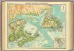
Maritime Provinces & Newfoundland.
1 : 2500000 John Bartholomew & Co.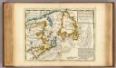
New Found Land, St. Laurence Bay, Acadia, New Scotland.
1 : 4800000 Moll, Herman, d. 1732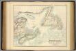
British North America. Sheet I, East.
1 : 2407680 Fullarton, A. & Co.
Nova Scotia And Newfoundland.
1 : 4300000 Tallis, J. & F.
A new & correct map of the Isles of New Foundland, Cape Breton &c. with the provinces of Nova Scotia / J. Gibson sculp.
1 : 4000000 Annotatie: Uit: The American gazetteer ... - London : A. Millar ; [etc.], 1762 Gibson, John (fl. 1762) [London : A. Millar] [etc.]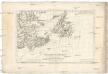
Isle et banc de Terre-Neuve, Isle Royale et Isle St. Jean, avec l'Acadie ou la Nouvelle Ecosse
1 : 5560000 Akádie Bonne, Rigobert André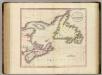
Nova Scotia, Newfoundland, &c.
1 : 2350000 Cary, John, ca. 1754-1835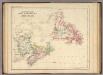
Newfoundland, New Brunswick, Nova Scotia, Cape Breton & Prince Edward Is.
1 : 3453120 Rogers, Henry Darwin