Maps of Argentina

United Provinces.
1 : 11800000 Lucas, Fielding Jr.
Map Of The United Provinces Of South America.
1 : 10771200 Lea, I.
Buenos-Ayres.
1 : 10700000 Buchon, J. A. C.; Carey, H. C.; Lea, I.
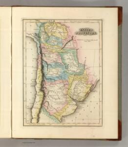
United Provinces.
1 : 12038400 Lucas, Fielding Jr.
Perou, Haut-Perou, Chili, La Plata.
1 : 9000000 Brue, Adrien Hubert, 1786-1832
Paraguay, Rio de la Plata, &c.
1 : 9500000 Bowen, Emanuel
Perou, Bolivie, Chili, Argentine, Paraguay, Uruguay.
1 : 8500000 Levasseur, E.
Perou, Haut-Perou, Chili, La Plata.
1 : 9000000 Picquet, C.
Argentine Republic, Chile, Paraguay, Uruguay.
1 : 5274720 Stanford, Edward
[Carte Physique de la Confédération Argentine]
1 : 2000000 Description géographique et statistique de la Confédération Argentine Martin de Moussy, Victor Librairie de Firmin Didot frères, fils et Cie
Chili, La Plata, Bolivia.
1 : 6800000 Hall, S. (Sidney)
[Carte du Bassin de la Plata]
1 : 2000000 Description géographique et statistique de la Confédération Argentine Martin de Moussy, Victor Librairie de Firmin Didot frères, fils et Cie
[Carte des Voyages du Dr. V. Martin de Moussy]
1 : 2000000 Description géographique et statistique de la Confédération Argentine Martin de Moussy, Victor Librairie de Firmin Didot frères, fils et Cie
Carte physique de la Confederation Argentine.
1 : 5650000 Martin de Moussy, V. (Victor), 1810-1869
Coupes geologiques diverses.
Sourdeaux, A.
Coupes geologiques diverses - altitudes.
Martin de Moussy, V. (Victor), 1810-1869
Carte de la Confederation Argentine.
1 : 5600000 Martin de Moussy, V. (Victor), 1810-1869
Coupes orographiques, territoire Argentin central.
1 : 1240000 Martin de Moussy, V. (Victor), 1810-1869
Carte des voyages du Dr. V. Martin de Moussy.
1 : 5650000 Martin de Moussy, V. (Victor), 1810-1869
Paraguay, Ó Prov. De Rio De La Plata cum regionibus adiacentibus Tucuman et S.ta Cruz De La Sierra. [Karte], in: Gerardi Mercatoris et I. Hondii Newer Atlas, oder, Grosses Weltbuch, Bd. 2, S. 413.
1 Karte aus Atlas Mercator, Gerhard und Hondius, Jodocus Jansson, Jan
La Plata.
1 : 4100000 Pinkerton, John, 1758-1826
[Carte de la Confédération Argentine]
1 : 2000000 Description géographique et statistique de la Confédération Argentine Martin de Moussy, Victor Librairie de Firmin Didot frères, fils et Cie
Bolivia, Chili, United Provinces.
1 : 7700000 Lizars, Daniel
Paraguay, ó prov. de Rio de la Plata cum regionibus adiacentibus Tucuman et Sta. Cruz de la Sierra
1 : 9500000
La Plata.
1 : 11500000 Arrowsmith, Aaron; Lewis, Samuel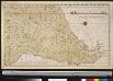
Het Zuijder gedeelt van America vertoonende Rio de la Plata met al sijn spruijte
South-America Gerard van Keulen
Paraquariae provinciae Soc. Iesu cum adjacentibus novissima descriptio
1 : 5000000 Jižní Amerika Seutter, Matthäus Tamburini, Michelangelo Matthäus Seutter
Chili et Argentine, Flle. Nord.
1 : 6000000 Vivien St Martin, L.