Maps of Great Lakes

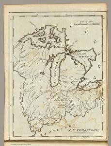
N. W. Territory.
1 : 8236800 Carey, Mathew
N.W. Territory.
1 : 8553600 Scott, Joseph
Upper Territories of the United States.
1 : 2060000 Carey, Mathew
Upper Territories of the United States.
1 : 3700000 Carey, Mathew
U.S. West of Mississippi R. 3.
1 : 2000000 Freyhold, Edward; Warren, Gouverneur Kemble, 1830-1882; United States. Army. Corps of Engineers
134-35. Mich., Wis., Minn., Ia., Mo., Ill., Ind., Ky.
1 : 3000000 Touring club italiano
200-201. United States of America, North East Central. The World Atlas.
1 : 2500000 USSR (Union of Soviet Socialist Republics).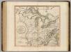
Western Terr., Kentucky, Pennsylvania, etc.
1 : 3300000 Cary, John, ca. 1754-1835
Western states, territories.
1 : 6400000 Grigg, John
Upper Territories of the the United States.
1 : 5900000 Lucas, Fielding Jr.
A new and general map of the middle dominions belonging to the United States of America: viz. Virginia, Maryland, the Delaware-counties, Pennsylvania, New Jersey &c. with the addition of New York, & of the greatest part of New England &c as also of the bordering parts of the British possessions in Canada.
from Parts Published by Laurie & Whittle, No. 53 Fleet Street ...: London; Robert Laurie and James Whittle,
Die Staaten von Missouri, Illinois, Indiana, Ohio, Kentucky und Tennessee

Lay's map of the United States / compiled from the latest and best authorities and actual surveys by Amos Lay, geographer and map publisher ; engraved by O.H. & D.S. Throop & Wm. Chapin.
From Whole
County map of Michigan, and Wisconsin.
from Mitchell's new general atlas, containing maps of the various countries of the world, plans of cities, etc., embraced in fifty-three quarto maps., forming a series of eighty four maps and plans, together with valuable statistical tables.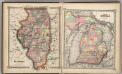
Illinois. Part of Michigan.
1 : 1900000 Schonberg & Co.
County map of the State of Illinois ; Plan of Chicago [inset].
from New general atlas.
Canada, Louisiane et Terres Angloises. (Northwest section)
1 : 2900000 Anville, Jean Baptiste Bourguignon d, 1697-1782
Country drained by the Mississippi Eastern Section.
1 : 4752000 Long, Stephen H.
Guide through Ohio, Michigan, Indiana, Illinois, Missouri, Wisconsin & Iowa : showing the township lines of the United States Surveys, location of cities, towns, villages, post hamlets, canals, rail and stage roads / by J. Calvin Smith ; engr. by S. Stiles, Sherman & Smith
1 : 2200000 Annotatie: Gerestaureerd en op Japans papier geplakt; Met statistische gegevens m.b.t. bevolking, landbouw en veeteelt, industrie en openbare financiën J. Calvin Smith; S. Stiles, Sherman & Smith New York, [N.Y.] : J.H. Colton & Co.
PARTIE OCCIDENTALE de la NOUVELLE FRANCE ou du CANADA
1 : 3600000 Velká kanadská jezera (Kanada a Spojené státy americké) Bellin, Jacques-Nicolas par le Heritiers de Homan
PARTIE OCCIDENTALE de la NOUVELLE FRANCE ou du CANADA
1 : 3600000 Velká kanadská jezera (Kanada a Spojené státy americké) Bellin, Jacques-Nicolas par les Heritiers de Homan
PARTIE OCCIDENTALE de la NOUVELLE FRANCE ou du CANADA
1 : 3600000 Velká kanadská jezera (Kanada a Spojené státy americké) Bellin, Jacques-Nicolas par les Heritiers de Homan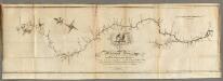
Map of the Mississippi River from its Source to the Mouth of the Missouri.
1 : 1584000 Pike, Zebulon Montgomery
Plan of Captain Carvers Travels in the interior Parts of North America.
1 : 2851200 Carver, Jonathan
Sheet 1: United States of Nth. America.
1 : 1584000 Tardieu, P.F.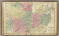
Western U.S.
1 : 3000000 Cornell, S. S. (Sarah S.)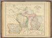
States of Michigan, Wisconsin and Iowa.
1 : 3453120 Rogers, Henry Darwin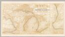
Northern Steamship Co. (map)
1 : 4752000 Northern Steamship Company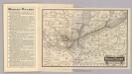
Map Wabash Railway.
1 : 6623200 Wabash Railway Company