Maps of Israel

Palestine.
1 : 60800000 Johnson, A.J.
Palestine.
1 : 1027000 Johnson, A.J.
Palestine.
1 : 60800000 Johnson, A.J.
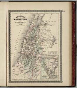
Palestine.
1 : 60800000 Johnson, A.J.
[Historisch-geographischer Atlas zu den allgemeinen Geschichtswerken von C. v. Rotteck, Pölitz u. Becker] : Palaestina von der Eroberung Josua's bis zum Untergange Juda's [&] Palaestine zur Zeit Jesu Christi nach Römischer Eintheilung
Julius Loewenberg Lithographie von B. Herder in Freiburg im Breisgau [Freiburg im Breisgau] : [Herder]
Carta della Palestina sotto il dominio de' Romani.
1 : 805000 Marzolla, Benedetto
Palestine sous la Domination Romaine.
Levasseur, E.
Palestine, Royaume des Israelites, Les Douze Tribus.
Malte-Brun, Conrad, 1775-1826
Palästina und Libanon
Adolf Stieler's Handatlas über alle Theile der Erde und über das Weltgebäude Stieler, Adolf Justus Perthes
Palestine, Israelites.
Mitchell, Samuel Augustus
Palestine ancienne & moderne d'après les sources les plus authentiques
1 : 600000 Andriveau-Goujon, E. (Eugène), 1832-1897 E. Andriveau-Goujon

151. Palestine and Lebanon. The World Atlas.
1 : 1250000 USSR (Union of Soviet Socialist Republics).
Carta della Palestina sotto il dominio de'Romani
1 : 680000 Marzolla, Benedetto [Verlag nicht ermittelbar]
Palestine sous la domination romaine.
1 : 800000 Brue, Adrien Hubert, 1786-1832
Palestine
1 : 1000000 Colton, G.W.
Palaestina
Hand-Atlas über alle Theile der Erde nach dem neuesten Zustande und über das Weltgebäude Stieler, Adolf bei Justus Perthes
[78][78] Terra Sancta, sive promissionis, olim Palestina, uit: Atlas sive Descriptio terrarum orbis
Annotatie: Gedigitaliseerde versie. Amsterdam. Heiloo : Picturae (vervaardiger), 2015. tiff-bestand. Gedigitaliseerd: 07-01-2015; Origineel: Universiteitsbibliotheek Vrije Universiteit (XL.05127.-) ; Netherlands; Titelpagina ontbreekt Wit, Frederik de Amsterdam : Frederick de Wit
Palastina. Das Libanon-Gebiet.
1 : 1200000 Petermann, A.
Terra Sancta, sive Promessionis, olim Palestina / recens delineata, et in lucem edita per Nicolaum Visscher
1 : 900000 Annotatie geografische gegevens: West boven Visscher, Nicolaes (1618-1679) [Amsterdam : C.J. Visscher]
Palästina
Hand-Atlas über alle Theile der Erde und über das Weltgebäude Stieler, Adolf Justus Perthes

Palaestina nach den zuverlässigsten alten und neuen Quellen
Hand-Atlas über alle Theile der Erde nach dem neuesten Zustande und über das Weltgebäude Stieler, Adolf bei Justus Perthes
Palästina
Handatlas über alle Theile der Erde und über das Weltgebäude Stieler, Adolf Justus Perthes

Palaestina.
Palestina Kiepert, Heinrich Arnd
Palestine (with) Arabia Petraea.
1 : 1013760 Colton, G.W.
Palestine & Adjacent Countries.
1 : 1160000 Mitchell, Samuel Augustus
Palaestina: ex veteris aevi monumentis ac recentiorum observationibus
1 : 450000 illustravit Marinus Didericus de Bruyn sculpsit Georgius Mayr Amstelodami : De Grebber