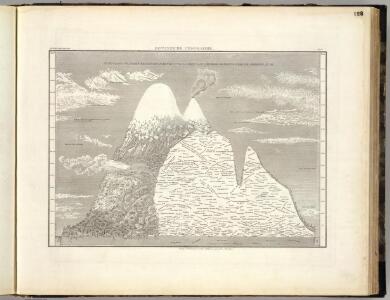
Maps of Cayambe

Botanische Geographie.
Meyer, Joseph, 1796-1856
Sud-America in zwei Blattern.
1 : 14000000 Stulpnagel, F.v.
Terre Ferme, Perou, Bresil, et du pays des Amazones.
1 : 9000000 L'Isle, Guillaume de, 1675-1726
Tabula Americae Specialis Geographica Regni Peru, Brasiliae, Terrae Firmae
1 : 9000000 Esta es una adaptación de la empresa Homann Heirs (también es conocida como Homann Erben, o herederos de Homann, en castellano) del mapa Carte de la Terre Ferme, du Perou, du Bresil, et du Pays des Amazones de Guillaume Del'Isle, originalmente publicado en Paris en 1703. La región amazónica aparece como “Terra Amazonum”, un lugar distinto y diferenciable de los territorios vecinos españoles (Tierra Firme, Peru, Paraguay) y portugueses (Brasil). La empresa Homann Heirs fue creada tras la muerte de Johann Baptiste Homann (1664-1724), famoso Geógrafo del Sacro Imperio Romano Germánico. A mediados del siglo XVIII la empresa estaba dirigida por el geógrafo Johann Michael Franz y por el grabador Johann Georg Ebersberg hijastro de Johann Baptiste Homann. La empresa funcionó en Núremberg hasta 1848 produciendo múltiples obras de geografía, atlas y mapas. Homann Erben (Empresa) L'Isle, Guillaume de (1675-1726)
Tabula Americæ specialis geographica regni Peru, Brasiliæ, Terræ Firmæ & reg: Amazonum
1 Karte : Kupferdruck ; 47 x 54 cm L'Isle; Herrera; Rodriguez; Acuña; Laet nunc recusa per Homannianos heredes
General-Charte von Süd America
Brazílie Spix, Johann Baptist von Martius, Carl Friedrich Philipp von
Terre Ferme, Perou, Bresil, Amazones.
1 : 9000000 L'Isle, Guillaume de, 1675-1726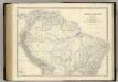
South America N.
1 : 8989200 Johnston, Alexander Keith, 1804-1871
Carte de la Terre Ferme, du Perou, du Bresil et du Pays des Amazones
1 : 9000000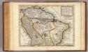
Map of Terra Firma, Peru, Amazone-Land, Brasil &c.
1 : 22000000 Moll, Herman, d. 1732
Süd-America in zwei Blättern
Hand-Atlas über alle Theile der Erde nach dem neuesten Zustande und über das Weltgebäude Stieler, Adolf bei Justus Perthes
Süd-America
Hand-Atlas über alle Theile der Erde nach dem neuesten Zustande und über das Weltgebäude Stieler, Adolf bei Justus Perthes
South America and West Indies.
1 : 10500000 Tanner, Henry S.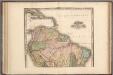
South America and West Indies.
1 : 10500000 Tanner, Henry S.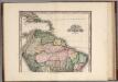
South America and West Indies. 1818
1 : 10500000 Tanner, Henry S.
Carte Generale d'une partie de l'Amerique du Sud .
1 : 8700000 Vivien de St Martin, L.
Sudamerika nordliches Blatt.
1 : 20000000 Andree, Richard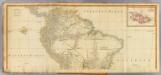
(South America north)
1 : 7900000 Anville, Jean Baptiste Bourguignon d, 1697-1782; Kitchin, Thomas; Robert Laurie & James Whittle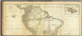
South America. (Northern Section)
1 : 7800000 Jefferys, Thomas
Peru and the Amazones, country. (Inset: the Gallapagos Islands.)
from New & accurate description of the earth in all its empires, kingdoms and states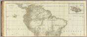
(A map of South America, northern section)
1 : 7900000 Kitchin, Thomas
South America.
1 : 30000000 Mitchell, Samuel Augustus
Map of South America.
1 : 30000000 Mitchell, Samuel Augustus
Di-gyiu Du, Ng Da-tsiu Di-du[地舆图、五大洲地图]
Di-gyiu Du, Ng Da-tsiu Di-du[地舆图、五大洲地图] 1853年,Martin, W. A. P. (William Alexander Parsons) 美国长老会传教士丁韪良用罗马拼音标注宁波方言编写的世界地理著作,对地球和各大洲进行介绍。内有东西半球图、亚洲图、欧洲图、非洲图、北美洲图、南美洲图、地中海附近图、清内地十八省图、浙江省图、宁波附近图等。 10图,墨刻本,罗马拼音标注宁波方言,图幅不一,约39 x 49.5 cm Harvard-Yenching | Rare Book | TA 2370 92,Hollis Number:008156153
萬國通鑑:南亞美利加
美国传教士撰的向中国人介绍世界地理概况的著作,后有世界地图册1份,共13幅世界、大洲和区域地图,其中一幅题为《中國地圖》的清朝内地地图。 Sheffield, Devello Zelotos 謝衛樓 福州 : 美華書局
Map of South America.
1 : 30000000 Mitchell, Samuel Augustus
Amerique Meridionale.
1 : 16000000 Levasseur, E.
South America.
1 : 12000000 Rand McNally and Company