Maps of Balkan Pen.

Europ. Turkey.
1 : 3100000 Radefeld, Carl Christian Franz, 1788-1874
Die Europaische Turkei.
1 : 2500000 Petermann, A.
Europäische Türkey
Grosser Hand-Atlas über alle Theile der Erde in 170 Karten Meyer, J. Verlag des Bibliographischen Instituts
Die Europäische Türkei
Hand-Atlas über alle Theile der Erde und über das Weltgebäude Stieler, Adolf Justus Perthes
Die Europäische Türkei
Handatlas über alle Theile der Erde und über das Weltgebäude Stieler, Adolf Justus Perthes
General-Karte von der europäischen Türkey
1 : 1000000 Bospor (Turecko : průliv) Kiepert, Heinrich Kratz, W. u. C. Dietrich Reimer
Generalkarte der Balkanhalbinsel
1 : 1580000 Balkánský poloostrov Handtke, Friedrich C. Flemming
Generalkarte der Balkanhalbinsel
1 : 1580000 Balkánský poloostrov Handtke, Friedrich C. Flemming
Státy Balkánské
Ethnographische Karte der europäischen Türkei und ihrer Dependenzen zu Anfang des Jahres 1877
Südosteuropa Ethnische Gruppe Sax, Carl
Ethnographische Karte von Europäischen Türkei...

Grenzen vor dem Kriege
Südosteuropa Osmanisches Reich Grenze
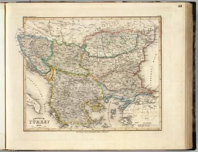
Turkey In Europe.
1 : 3600000 Colton, G.W.
Grenzen Herbst 1913
Südosteuropa Osmanisches Reich Grenze Balkankrieg <1912-1913>
Colton's Turkey in Europe.
1 : 1600000 Colton, G.W.
Turecko evropské, Srbsko, Multany a Valachie, Černá Hora a pohraničné země rakouské
1 : 2300000 Evropa jihovýchodní Vaclík, Jan Wagner, Jan Eduard Jaroslav Pospíšil
Turecko evropské, Srbsko, Multany a Valachie, Černá Hora a pohraničné [sic] země rakouské
1 : 2300000 Evropa jihovýchodní Vaclík, Jan Wagner, Jan Eduard nákladem Jaroslava Pospíšila
Turecko evropské, Srbsko, Multany a Valachie, Černá Hora a pohraničné země rakouské
1 : 2500000 Evropa jihovýchodní Vaclík, Jan Wagner, Jan Eduard Jaroslav Pospíšil
Turecko evropské
1 : 2300000 Evropa jihovýchodní Wagner, Jan Eduard Vaclík, Jan nákladem Jaroslava Pospíšila
Turecko evropské, Srbsko, Multany a Valachie, Černá Hora a pohraničné [sic] země rakouské
1 : 2300000 Evropa jihovýchodní Vaclík, Jan Wagner, Jan Eduard nákladem Jaroslava Pospíšila
Turecko evropské, Srbsko, Multany a Valachie, Černá Hora a pohraničné země rakouské
1 : 2300000 Evropa jihovýchodní Vaclík, Jan Wagner, Jan Eduard Jaroslav Pospíšil
Das Erste Bulgarische Reich (680-1018 n. Chr.)
Bulgarien
Balkan
Balkanhalbinsel
Das Zweite Bulgarische Reich (1087-1256 n. Chr.)
Bulgarien
Carte de la Turquie d'Europe
Balkánský poloostrov Boué, A. Arthus-Bertrand chez Arthus-Bertrand
Turkey in Europe.
1 : 3000000 Colton, G.W.
General-Karte der europäischen Türkei und des Vladikats Montenegro
1 : 1580000 Bospor (Turecko : průliv) Handtke, J. C. Flemming
General-Karte der europäischen Türkei und des Vladikats Montenegro
1 : 1580000 Balkánský poloostrov Handtke, J. Flemming, C. C. Flemming
General-Karte der europäischen Türkei und des Vladikats Montenegro
1 : 1580000 Balkánský poloostrov Handtke, J. Flemming, C. C. Flemming