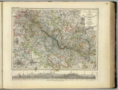
Maps of Landkreis Schmalkalden-Meiningen

Thuringer-Wald-Gebirges.
1 : 380000 Grassl, J. (Joseph)
Karte des Thüringer-Wald-Gebirges zugleich special Karte des Herzogthums Sachs-Meiningen-Hildburghausen des Fürstenthums Coburg und der Schwarzburgischen Fürstenthümer Rudolstadt und Sondershausen
Grosser Hand-Atlas über alle Theile der Erde in 170 Karten Meyer, J. Verlag des Bibliographischen Instituts
Herzogtum Sachsen-Meiningen 1829 Verwaltungsstruktur
Sachsen-Meiningen Verwaltung Kunz, Andreas ; Moeschl, Joachim Robert
Herzogtum Sachsen-Meiningen 1826 Verwaltungsstruktur
Sachsen-Meiningen Verwaltung Kunz, Andreas ; Moeschl, Joachim Robert
Principatus Isenacensis cum adjacentibus vicinorum statuum ditionibus exhibitus
1 : 190000 Durynsko (Německo) Homann, Johann Baptist J. B. Homann
Special Charte von dem Thüringer Walde
Durynský les (Německo) von dem Geographischen Institute
Geographische Charte
1 : 300000 Mollova mapová sbírka Zollmann, Friedrich
Principatus Isenacensis
1 : 210000 Mollova mapová sbírka Homann, Johann Baptist Homann, Johann Baptista

Tvringiae Noviss. descript.
1 : 520000 Mollova mapová sbírka Mellinger, Johann Plantin, Christoph (officina)
Carte pour Servir de Suite à la Partie Meridionale du Landgraviat de Hesse-Cassel avec les pays voisins de la Thüringe
1 : 200000 Mollova mapová sbírka Brönner, Heinrich Ludwig Broenner, Heinrich Ludwig
Herzogtum Sachsen-Coburg und Gotha 1830 Verwaltungsstruktur
Sachsen-Coburg-Gotha Verwaltung Kunz, Andreas ; Moeschl, Joachim Robert
Herzogtum Sachsen-Coburg und Gotha 1826 Verwaltungsstruktur
Sachsen-Coburg-Gotha Verwaltung Kunz, Andreas ; Moeschl, Joachim Robert
Herzogtum Sachsen-Coburg und Gotha 1834 Verwaltungsstruktur
Sachsen-Coburg-Gotha Verwaltung Kunz, Andreas ; Moeschl, Joachim Robert
Hennebergensis Ditionis. vera delineatio [Karte], in: Theatrum orbis terrarum, S. 225.
1 Karte aus Atlas Ortelius, Abraham Vrients, Jan Baptista
Principatus Hennenbergensis. [Karte], in: Novus atlas absolutissimus, Bd. 2, S. 177.
1 Karte aus Atlas Janssonius Offizin
Hennebergensis Ditionis. vera delineatio [Karte], in: Theatrum orbis terrarum, S. 133.
1 Karte aus Atlas Ortelius, Abraham
COMITATVS | HENNEBER- | GENSIS.
[Amsterdam : Joan Blaeu]
Zu den Operationen der Generale Syburg, Schenkendorf und Linden gegen die Reichsarmee, vom 15ten Februar bis zum 5ten April 1761

Herzogtum Sachsen-Meiningen 1820 Verwaltungsstruktur
Sachsen-Meiningen Verwaltung Kunz, Andreas ; Moeschl, Joachim Robert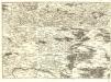
S.R.Imp. Circuli Franconici Geographica Delineatio Francken-Land mit Seinen Gräntzen
Mollova mapová sbírka Endter, Wolfgang Moritz Endter, Wolfgang Moritz
Coburg
1 : 300000 R. Mittelbach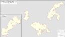
Herzogtum Sachsen-Coburg-Saalfeld 1820 Verwaltungsstruktur [mit] Fürstentum Lichtenberg
Sachsen-Coburg-Saalfeld Verwaltung Kunz, Andreas ; Moeschl, Joachim Robert
Geognostische Uebersichtskarte des Thüringer Waldes
1 : 100000 Beyschlag, Franz ; Pütz, M. Simon Schropp
S. R. I. Comitatvs Henneberg
1 : 150000 Mollova mapová sbírka Zinck, Johann Jacob Homann, Johann Baptista - dědici
S. R. I. Comitatvs Henneberg
1 : 150000 Mollova mapová sbírka Zinck, Johann Jacob Homann, Johann Baptista - dědici
Regiae Celsitudini Serenissimo Principi ac Domino Friderico Christiano Leopoldo
1 : 200000 Mollova mapová sbírka Zollmann, Johann Wilhelm Oetinger, Christ. Friedrich Homann, Johann Baptista - dědici
Der Thüringerwald

Principatus Hennenbergensis
1 : 300000 Mollova mapová sbírka Hondius, Henricus Schenk, Peter I