Maps of Portugal

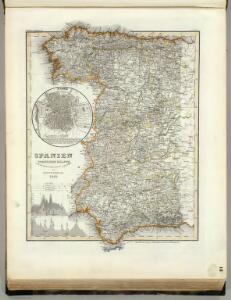
Spanien west.
1 : 2350000 Radefeld, Carl Christian Franz, 1788-1874
Spanien westliche Hälfte
Grosser Hand-Atlas über alle Theile der Erde in 170 Karten Meyer, J. Verlag des Bibliographischen Instituts
39-40. Spagna, Portogallo ouest.
1 : 1500000 Touring club italiano
Carte nouvelle et curieuse du royaume d'Espagne / C. Inselin, 1
1 Blatt : Inselin
Spain and Portugal.
1 : 4308480 Tallis, J. & F.
[Iberische Halbinsel]
1 : 30000000 Iberische Halbinsel Österreichischer Erbfolgekrieg
Carte de la Peninsule Hispanique.
1 : 2750000 Vivien de St Martin, L.
[132][135] Hispaniae, et Portugalliae Maritimi tractus, uit: Atlas sive Descriptio terrarum orbis
Annotatie: Gedigitaliseerde versie. Amsterdam. Heiloo : Picturae (vervaardiger), 2015. tiff-bestand. Gedigitaliseerd: 07-01-2015; Origineel: Universiteitsbibliotheek Vrije Universiteit (XL.05127.-) ; Netherlands; Titelpagina ontbreekt Wit, Frederik de Amsterdam : Frederick de Wit
El reyno de Portugal subdividido en muchas provincias
1 Karte : Kupferdruck ; 67 x 50 cm Longchamps en casa del autor, en casa del Barthelmy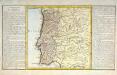
Le royaume de Portugal
1 Karte : Kupferdruck ; 30 x 31 cm, Bildgrösse 32 x 55 cm Clouet Mondhare
Portugal, Algarve.
1 : 1250000 Robert Laurie & James Whittle
Le Portugal et ses rontieres avec l'Espagne / par ordre de M. le duc de Choiseul par le Sr. Bellin
1 Mapa, b/n. Datació aproximada. Bellin, Jacques Nicolas Dépôt de la Marine
Les frontieres d'Espagne et de Portugal
1 Karte : Kupferdruck ; 57 x 42 cm Fer; Starckman chez l'auteur dans l'isle du Palais sur le quay de l'orloge a la sphere royale
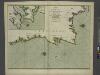
The coasts of PORTUGALL and part of SPAIN from cape finifterre to Gibralter
from The sea-atlas : containing an hydrographical description of most of the sea-coasts of the known parts of the world.
Partie, l'Espagne, Portugal. Europe 24.
1 : 1641836 Vandermaelen, Philippe, 1795-1869
Portugal.
1 : 915000 Pinkerton, John, 1758-1826
Map of Portugal.
1 : 2200000 Bowen, Emanuel
Espagne et Portugal. Flle. N.O.
1 : 1250000 Vivien St Martin, L.
Les royaumes de Portugal et des Algarves
1 Karte : Kupferdruck ; 50 x 62 cm Delafosse; Mondhare chez Mondhare rue S. Jacques près S. Severin
Mapa dos reynos de Portugal e Algarve
1 Karte : Kupferdruck ; 58 x 41 cm Lattré; Rizzi-Zannoni; Marillier; Berthault en casa de M. Lattré
Portugall.
from A new systeme of the mathematicks: containing I. Arithmetick, as well natural and decimal, as in species, or the principles of algebra. II. Practical geometry, together with the first six books of Euclid's Elements, as also the eleventh and twelfth, symbo
Karte von den Königreichen Portugal und Algarbien
1 Karte : Kupferdruck ; 48 x 33 cm Sotzmann; López; Ramberg; Rizzi-Zannoni; Büsching; Jefferys s.n.
A new Military Map of Spain and Portugal compiled from The Nautical Surveys of Don Vincent Tofiño, the new Provincial maps of Don Tomas Lopez, the large map of the Ptrenees by Roussill, and various original documents
1 Mapa en 4 seccions dins d'un estoig. John Stockdale J. Stockdale
Portugalliae et Algarbiae regna
1 : 1740000 Algarve (Portugalsko) Seutter, Matthäus cura et studio Matthaei Seutteri
Royaume de Portugal
1 Karte : Kupferdruck ; 32 x 42 cm Mentelle; Tardieu E. Mentelle
Castilia Estremadvra Æsturie Nauarra
1 Karte : Kupferdruck ; 15 x 21 cm Lambert Andreae
Perfectissima geographica delineatio Regnorum Vandalitiae, Granatae, et Algarbiae; tractuum, Meridionalium Portugalliae Extremadurae ac Castellae Novae
1 : 1100000 summâ diligentià correcta et edita a R. & I. Ottens Amst. Batavo. Amst. R. & I. Ottens
Utriusque Castiliae nova descriptio. [Karte], in: Novus atlas absolutissimus, Bd. 6, S. 40.
1 Karte aus Atlas Janssonius Offizin