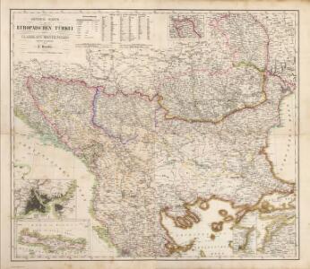
Maps of Balkan Pen.

Composite: Europaischen Turkei.
1 : 1580000 Handtke, Friedrich H.
Turkey In Europe.
1 : 3600000 Colton, G.W.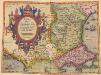
Romaniae, (quae olim Thracia dicta) Vicinarumque Regionum, Uti Bulgariae, Walachiae, Syrfiae, Etc. Descriptio. [Karte], in: Theatrum orbis terrarum, S. 283.
1 Karte aus Atlas Ortelius, Abraham
Turkey In Europe.
1 : 4942080 Tallis, J. & F.
Carte de la Turquie d'Europe
1 : 1270000 Evropa jihovýchodní Konrad, Al. Palma, G. chez Artaria et Compagnie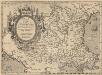
Romaniae, (quae olim Thracia dicta) Vicinarumque Regionum, Uti Bulgariae, Walachiae, Syrfiae, Etc. Descriptio. [Karte], in: Theatrum orbis terrarum, S. 378.
1 Karte aus Atlas Ortelius, Abraham Vrients, Jan Baptista
Turkey in Europe.
1 : 3000000 Colton, G.W.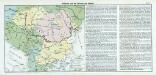
Nr. 17. Bulgarien und die Nationen des Balkans
Balkanhalbinsel, Bulgarien
Schul-Atlas für die alte Erdbeschreibung : zur allgemeinen Schul-encyclopädie gehörig
J. H. Campe Zusammensetzung und Zeichnung von [...] Dufour, unter Leitung von Heusinger ; gestochen von Frentzel. Braunschweig : Schulbuchhandlung

Turkey in Europe.
1 : 4000000 Colton, G.W.
Turkey in Europe.
1 : 4000000 Colton, G.W.
Die Transhumanz der dakorumänischen, aromunischen, meglenorumänischen und istrorumänischen Hirten
Balkanhalbinsel Transhumanz, Walachen Willing, P.
Regiones Danvbianae, Pannoniae Dacia ?oesiae cum Vicino Illyrico
1 : 4100000 Mollova mapová sbírka Weigel, Christoph Weigel, Christoph I.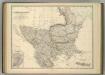
Turkey in Europe.
1 : 2533000 Johnston, Alexander Keith
Turkey and Greece.
1 : 3380000 Sharpe, J.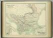
Turkey in Europe.
1 : 2533000 Johnston, W. & A.K.
Map of the Balkan States
Balkanhalbinsel
Le Royaume de Hongrie et les Estats qui en ont été sujets et qui font presentem la Partie Septentrionale de la Turquie en Europe
1 : 2900000 Mollova mapová sbírka Sanson, Guillaume Sanson, Guillaume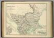
Turkey in Europe.
1 : 2533000 Johnston, Alexander Keith
Hungaria cum reliqua modernicum Turcis belli sedes
1 : 3600000 Balkánský poloostrov Biberger, Johann Ulrych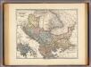
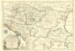
Pannonia, Illyricum, Dacia, Moesia, Thracia, Macedonia, Epirus.
1 : 4000000 Menke, Th.
Turkey in Europe.
1 : 3600000 Greenleaf, Jeremiah
Turkey in Europe.
1 : 3600000 Greenleaf, Jeremiah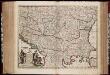
Nova totius Hungariae, Transilvaniae, Serviae, Romaniae, Bulgariae, Walachiae, Moldaviae, Sclavoniae, Croatiae, Bosniae, Dalmatiae, maximaeq[ue] partis Danubii fluminis, descriptio / emendata a F. de Wit
1 : 2600000 Annotatie: Tekst impressum in het Nederlands; Rechtsboven: 21; Kaart toont Hongarije, omliggende landen en een belangrijk deel van de loop van de Donau; Origineel is Blad 129 in atlas factice; Annotatie geografische gegevens: Schaalstok linksonder cartouche: Milliaria Germanica communia 15 uni gradui = Gemeene Duytsche Mylen van 15 in een graedt Frederick de Wit 1630-1706 Amsterdam : gedruckt by Frederick de Wit inde Kalverstraet by den Dam inde Witte Pascaert
Völkerkarte
Balkanhalbinsel Ethnische Gruppe
[Kaart], uit: Ethnographische Übersicht des Europäischen Orients / zsgest. von H. Kiepert
1 : 3000000 titelvariant: Ethnographische Übersichtskarte des Europäischen Orients; Annotatie: Omslagtitel: Ethnographische Übersichtskarte des Europäischen Orients : (untere Donauländer, Turkei und Griechenland); Met toelichting in de omslag (12 p.) Johann Samuel Heinrich Kiepert 1818-1899 Berlin : Reimer
Ancient Macedonia, Thracia, Illyria, Moesia, and Dacia
1 : 3000000 published under the superintendence of the Society for the Diffusion of Useful Knowledge engraved by J. & C. Walker London : Baldwin and Cradock