Maps of Ukraine

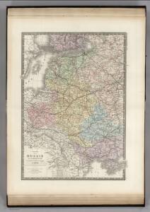
Russia Occidentale, Pologne Ancien.
1 : 4200000 Levasseur, E.
Russie occidentale, Pologne.
1 : 4060000 Picquet, C.
Russie occidentale, Pologne.
1 : 4060000 Brue, Adrien Hubert, 1786-1832
Übersicht des österrechisch-russischen Kriegsschauplatzes

Karta teatra Sěvernoj vojny. Perīod 1707 - 1709 gg.
Russland Nordischer Krieg <1700-1721>
[Osteuropa]
Evropa východní
Friedensdislokation im europäischen Russland
1 : 2800000 Evropa východní
G. Freytags Karte der westrussischen Kriegsschauplätze
1 : 2000000 Evropa východní Freytag, Gustav G. Freytag & Berndt
Polen nach der zweiten Theilung 1793
1 : 20000000 Polen Teilung Polens <1793>
Polen nach der ersten Theilung 1772
1 : 20000000 Polen Teilung Polens <1772>
Polen und Litthauen 1125-1386.
1 : 5000000 Spruner von Merz, Karl
Polen vor dem Frieden v. Andrussow 1667
1 : 20000000 Polen-Litauen Russisch-polnischer Krieg <1654-1667>
Polen vom Anfange des XVIII Jahrhunderts bis zum Untergange der Republik 1795
1 : 5000000 Polen-Litauen, Teilungen Polens
Polen nach der dritten Theilung 1795
1 : 20000000 Polen Teilung Polens <1795>
Regni Poloniae et ducatus Lithvaniae Voliniae, Podoliae Vcraniae Prvssiae, Livoniae et Cvrlandiae / descriptio emendata per F. de Wit Amstelodami
1 : 3000000 Annotatie: Rechtsboven: 14; Origineel is Blad 132 in atlas factice; Annotatie geografische gegevens: Met schaalstok: 15 Duytsche Mylen Frederick de Wit 1630-1706 [Amsterdam : F. de Wit]
Polen und Litthauen nach der Lubliner Union 1569 und dem Aussterben der Jagiellonen 1572
1 : 12000000 Polen-Litauen
Regni Poloniae Magnique Ducat[us] Lithuaniae Nova et exacta Tabula
1 : 3000000 Homann, Johann Baptist
[71][71] Regni Poloniae et Ducatus Lithuaniae ..., uit: Atlas sive Descriptio terrarum orbis
Annotatie: Gedigitaliseerde versie. Amsterdam. Heiloo : Picturae (vervaardiger), 2015. tiff-bestand. Gedigitaliseerd: 07-01-2015; Origineel: Universiteitsbibliotheek Vrije Universiteit (XL.05127.-) ; Netherlands; Titelpagina ontbreekt Wit, Frederik de Amsterdam : Frederick de Wit
Regni Poloniae Magniquae Ducatus Lithuaniae Nova et exacta tabula
1 : 3000000 Litva Homann, Johann Baptist Starowolski, Szymon a Ioh. Bapt. Homanno
Volker und Reiche der Slaven zwischen Elbe und Don bis 1125.
1 : 5000000 Spruner von Merz, Karl
Polska za Stefana Batorego roku 1586
Evropa jihovýchodní
Polska za Mieczysława I. roku 992
Evropa jihovýchodní
Polska za Kazimirza Wielkiego roku 1370
Evropa jihovýchodní
Sławiańszczyzna przed powstaniem Polski roku 850
Evropa jihovýchodní
Polska za Jana Alberta roku 1500
Evropa jihovýchodní
Polska za Jana Kazimirza i za Michała Wisniowieckiego 1673, klęski od roku 1648 do 1717
Evropa jihovýchodní
Polska za Zygmunta Augusta roku 1572
Evropa jihovýchodní
Polska za Stanisława Augusta podzielona 1772, 1793, 1795
Evropa jihovýchodní
Polska za Bolesława Wielkiego roku 1025
Evropa jihovýchodní