Maps of Great Lakes

United States Of North America.
1 : 1550000 Arrowsmith, Aaron
Die Staaten von Missouri, Illinois, Indiana, Ohio, Kentucky und Tennessee

Les États Unis de l'Amérique septentrionale
1 : 6050000 Spojené státy americké-oblast západní Bonne, Rigobert André
Map showing the connections of the Illinois Central Railroad with the railway lines to the Gulf ports / engraved by H.H. Lloyd & Co.
1 : 2300000 H. H. Lloyd & Co, New York, N.Y [S.l. : s.n.]
Upper Territories of the United States.
1 : 2060000 Carey, Mathew
Upper Territories of the United States.
1 : 3700000 Carey, Mathew
N.W. Territory.
1 : 8553600 Scott, Joseph
Il paese de' Selvaggi Outagamiani, Mascoutensi, Illinesi, e parte delle VI. Nazioni.
from Le colonie unite dell' America settentrle : di nuova projezione a s.s.e.e. li Signori Riformatori dello Studio di Padova.
134-35. Mich., Wis., Minn., Ia., Mo., Ill., Ind., Ky.
1 : 3000000 Touring club italiano
G.W. Colton's Map of the Country 500 miles around Cairo
G.W. Colton's Map of the Country 500 miles around Cairo, showing the Seat of War in the West, by G.W. Colton. This Colton map from 1862 showing 500 Miles around Cairo details the western seat of the war with Illinois at the centre point and shows both Union and Confederate States. The map helps to give a sense of scale to the war as it stretched across much of the country, particularly the eastern and middle states with the southern Illinois town of Cairo close to the tempestuous Border States of Kentucky and Missouri and the northern part of the Confederacy. The map also lists fortifications in the Western and Gulf states and the principal towns and cities along the Ohio and Mississippi Rivers.
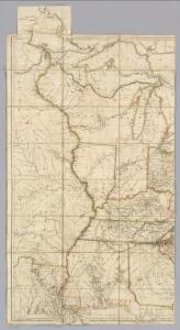
U.S. West of Mississippi R. 3.
1 : 2000000 Freyhold, Edward; Warren, Gouverneur Kemble, 1830-1882; United States. Army. Corps of Engineers
200-201. United States of America, North East Central. The World Atlas.
1 : 2500000 USSR (Union of Soviet Socialist Republics).
Western Terr., Kentucky, Pennsylvania, etc.
1 : 3300000 Cary, John, ca. 1754-1835
Country drained by the Mississippi Eastern Section.
1 : 4752000 Long, Stephen H.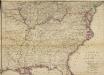
Woolley's new Map of the Seat of War in the Confederate States of America.
Woolley's new Map of the Seat of War in the Confederate States of America. Published in London, probably in 1861, Woolley’s New Map of the Seat of War in the Confederate States of America details the whole eastern half of the country. The red and green lines indicated which states held slaves and which states did not. The map shows all the Confederate states, excluding Texas, and shows how the Border States of Missouri and Kentucky were also slave-holding despite remaining part of the Union. H.G. Clarke & Co.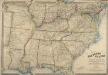
Map of the Southern States of North America, with the Forts, Harbours, and Military Positions
Map of the Southern States of North America, with the Forts, Harbours, and Military Positions. This map, published by Wyld in 1865, shows much of the Confederacy and the Border States as they were at the end of the Civil War. The divide between Virginia and West Virginia is marked, along with ‘forts, harbours & military positions’. The dark black lines indicated railway routes and it is notable how many more there are in the small segment of the Northern states displayed at the top of the map in comparison to the Confederate states. J. Wyld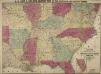
Lloyd's New Military Map of the Border and Southern States
Lloyd's New Military Map of the Border and Southern States. This map was published by H.H. Lloyd & Co. in 1862. The map shows mid America from the lower border of the Union to the eastern edge of Texas, thus showing all eleven Confederate states. Railway lines and fortifications are also labelled on the map.
Upper Territories of the the United States.
1 : 5900000 Lucas, Fielding Jr.
Western states, territories.
1 : 6400000 Grigg, John
N. W. Territory.
1 : 8236800 Carey, Mathew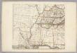
Sheet 3: United States of Nth. America.
1 : 1584000 Tardieu, P.F.
Sheet 1: United States of Nth. America.
1 : 1584000 Tardieu, P.F.
County map of Michigan, and Wisconsin.
from Mitchell's new general atlas, containing maps of the various countries of the world, plans of cities, etc., embraced in fifty-three quarto maps., forming a series of eighty four maps and plans, together with valuable statistical tables.
Guide through Ohio, Michigan, Indiana, Illinois, Missouri, Wisconsin & Iowa : showing the township lines of the United States Surveys, location of cities, towns, villages, post hamlets, canals, rail and stage roads / by J. Calvin Smith ; engr. by S. Stiles, Sherman & Smith
1 : 2200000 Annotatie: Gerestaureerd en op Japans papier geplakt; Met statistische gegevens m.b.t. bevolking, landbouw en veeteelt, industrie en openbare financiën J. Calvin Smith; S. Stiles, Sherman & Smith New York, [N.Y.] : J.H. Colton & Co.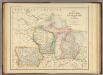
States of Michigan, Wisconsin and Iowa.
1 : 3453120 Rogers, Henry Darwin
United States.
1 : 3380000 Sharpe, J.
Sheet 3: United States of Nth. America.
1 : 1584000 Tardieu, P.F.
County map of the State of Illinois ; Plan of Chicago [inset].
from New general atlas.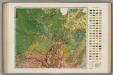
Soil Map of the United States, Section 7. Atlas of American Agriculture.
1 : 2500000 Marbut, Curtis F.
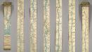
Ribbon Map Of The Father Of Waters.
1 : 1267200 Coloney, Fairchild & Co.