Maps of United States

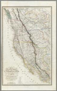
Carte De La Cote De L'Amerique.
1 : 5555555 Duflot de Mofras, Eugene
Map of the United States
from County atlas of Cayuga, New York. From recent and actual surveys and records under the superintendence of F. W. Beers.
Map of the United States
from Atlas of Madison County, New York : from actual surveys / by and under the direction of D. G. Beers.
North America, 1782.
1 : 28000000 Jefferys, Thomas
Facsimile: Walch's North America (portion).
1 : 13000000 Walch, Joh.
Louisiana.
1 : 23500000 Carey, Mathew
Louisiana.
1 : 21000000 Lewis, Samuel
Louisiana.
1 : 21000000 Lewis, Samuel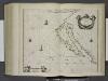
Paskaerte van Nova Granada en t'Eylandt California.
from De zee-atlas ofte water-wereld : waer in vertoont werden alle de zee-kusten van het bekende des aerd-bodems : seer dienstigh voor alle heeren en kooplieden, als oock voor alle schippers en stuurlieden / by Pieter Goos.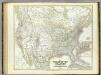
Vereinigten Staaten von N. America.
1 : 8000000 Kiepert, Heinrich, 1818-1899
194-195. United States of America. The World Atlas.
1 : 10000000 USSR (Union of Soviet Socialist Republics).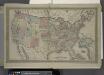
Map of The United States
from Atlas of Franklin County, New York. : From actual surveys and official records.
United States of America.
1 : 22000000 Colton, G.W.
Gray's Geological Map of the United States
from New illustrated atlas of Dutchess County, New York. / Compiled & drawn from personal examinations, surveys etc. under the personal supervision of O.W. Gray & Son and F.A. Davis, and published under the superintendence of H. L. Kochersperger.
A New Map of Texas Oregon and California With The Regions Adjoining.
1 : 6652800 Mitchell, Samuel Augustus
Composite: Vereinigte Staaten v. Nordamerika.
1 : 8000000 Berghaus, Heinrich; Flemming, Carl; Sohr, Karl
Ornamental Map Of The United States & Mexico.
1 : 13000000 Ensigns & Thayer
A New Map of Texas Oregon and California With The Regions Adjoining.
1 : 6652800 Mitchell, Samuel Augustus
A New Map of The States Of Texas & California
1 : 6652800 Mitchell, Samuel Augustus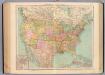
127-28. Stati Uniti.
1 : 10000000 Touring club italiano
A new map of the United States of America
1 : 8750000 Facsimile. "The United States in 1856 as reproduced by Rand McNally & Company to commemorate its one hundredth anniversary in 1956." Relief shown by hachures. Shows railroad routes proposed to the Pacific Ocean. Includes insets: Gold region of California and District of Columbia. Longitude on top of map "West from Greenwich;" on bottom "East/West from Washington." Printed with ornamental border. "Entered according to Act of Congress in the year 1856 by Charles Desilver, in the Clerks office of the District court of the Eastern District of Pennsylvania." Screen reader support enabled. Young, J. H. (James Hamilton) Philadelphia : Published by Charles Desilver, 1856. ([Chicago] : Rand Mcnally 1956)
Composite: Map of Louisiana and Mexico.
1 : 4300000 Tardieu, P.F.
Central America and Yucatan (Mexico).
from The cerographic atlas of the United States. By Sidney E. Morse, A.M., and Samuel Breese, A.M.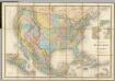
Carte Generale Des Etats.
1 : 7285000 Andriveau-Goujon, E.
Vereinigte Staaten
1 : 18500000 Severní Amerika Biller, Franz
Maris Pacifici, America.
Schoner, Johann
Map of the United States and Mexico: including Oregon, Texas and the Californias.
from Parts s.n.: [New York?],
Facsimile: Hudsons Bay Company Map of North America.
1 : 15300000 Hudson's Bay Company
Uebersichts-Karte der ethnographischen Verhältnisse von Asien und von den angrenzenden Theilen Europa'sbearbeitet und herausgegeben mit Unterstützung der kaiserlichen Akademie der Wissenschaften in Wien von Vinzenz v. Haardt
Hartenthurn, Vincenz