Maps of El Arish
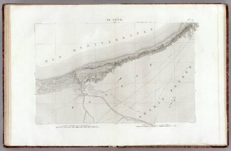
32 El Arich.
1 : 100000 Jacotin, Pierre, 1765-1827
Palestine campaign (1921)
Palestine campaign: Situation at 1800 on 1st Nov. 1917 (24 hours after the capture of Beersheba), GSGS 2965. Great Britain. General Staff. Geographical Section. [London] : [GSGS, War Office]
(Sheet 3). Western Palestine Natural Drainage and the Mountain Ranges.
1 : 168960 Kitchener, H.R. (Horatio Herbert)
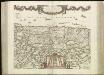
Sitvs terrae Canaan, sive Terrae promissionis, hodie Palaestinae, Ss. Bibliorvm intelligentiam exacte aperiens
Kanaán Sanson, Nicolas Adrichem, Christiaan van Pierre Mortier
Palestina za doby soudců a králů

Palestina nynější
Iudaea seu terra sancta
1 : 600000 Izrael Sanson, Guillaume Cordier, Louis apud Hubertum Iaillot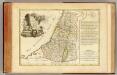
Douze Tribus d'Israel.
1 : 1030000 Bonne, Rigobert, 1727-1794
Palestine sous Constantin le Grand, 330 apres J.C.
1 : 2750000 Houze, Antoine Philippe
Iudaea seu Terra Sancta quae Hebraeorum sive Israelitarum in suas duodecim tribus divisa, secretis ab invicem regnis Iuda et Israel expressis insuper sex ultimi temporis ejusdem terrae provinciis
1 : 615000 Izrael Sanson, Guillaume Mortier, Pieter apud Petrum Mortier
Afbeelding van 't Joodsche land toen het aan de heerschappy der Romeinen onderworpen, met derzelver vergunning bestiert wierd, door koning Herodes den Groten, en deszelfs nageslagt : strekkende tot opheldering der geschiedenis van Christus
1 : 900000 door W.A. Bachiene J. van Jagen mapp. sculpsit, et figur. apposit. sculpturam curavit ; S. Fokke fecit. te Gorinchem : by Nicol: Goetzee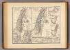
Syria Phoenice, Syria Palaestina, Provinciae ab aerae Christianae anno 70 usque ad Diocletiani tempus; Phoenice, Coelesyria, Decapolis, Iudaea Herediadarum tempore.
1 : 2000000 Menke, Th.
Carte de la presqu'ile de Sinai
1 : 1000000 Sinajský poloostrov (Egypt) Service géographique de l'Armée
Geognostische Karte des peträischen Arabien und den südlichen Theiles von Sirien
1 : 880000 Sinajský poloostrov (Egypt) E. Schweizerbart'sche Buchhandlung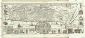
Chorographia Terrae Sanctae in angvstiorem formam redacta, et ex variis avctoribvs a mvltis erroribvs expvrgata
1 : 400000 Izrael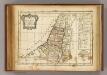
12 tribus d'Israel.
1 : 2000000 Delamarche, Charles Francois
[78][78] Terra Sancta, sive promissionis, olim Palestina, uit: Atlas sive Descriptio terrarum orbis
Annotatie: Gedigitaliseerde versie. Amsterdam. Heiloo : Picturae (vervaardiger), 2015. tiff-bestand. Gedigitaliseerd: 07-01-2015; Origineel: Universiteitsbibliotheek Vrije Universiteit (XL.05127.-) ; Netherlands; Titelpagina ontbreekt Wit, Frederik de Amsterdam : Frederick de Wit

Typus Chorographicus, Celebrium Locorum In Regno Iudae Et Israhel. [Karte], in: Theatrum orbis terrarum, S. 436.
1 Karte aus Atlas Ortelius, Abraham
151. Palestine and Lebanon. The World Atlas.
1 : 1250000 USSR (Union of Soviet Socialist Republics).
Terra Sancta, sive Promessionis, olim Palestina / recens delineata, et in lucem edita per Nicolaum Visscher
1 : 900000 Annotatie geografische gegevens: West boven Visscher, Nicolaes (1618-1679) [Amsterdam : C.J. Visscher]
Abrahami patriarchae peregrinatio, et vita
1 : 2200000 Egypt Ortelius, Abraham Moflinius, Iohannes Abraham Ortelius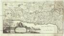
Carte de la Terre Promise
1 : 1600000 Izrael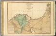
Lower Egypt, Palestine.
1 : 755000 Faden, William, 1750?-1836
PALAESTINA in XII. TRIBVS divisa, CVM TERRIS ADIACENTIBVS denuo revisa & copiosior reddita
1 : 1060000 Izrael Harenberg, Johann Christoph curantibus Homannianis Heredibus
Palaestina in XII. tribvs divisa, cvm terris adiacentibvs
1 : 1028000 Izrael Harenberg, Johann Christoph curantibus Homannianis Heredibus
Palaestina in XII. tribvs divisa, cvm terris adiacentibvs denuo revisa & copiosior reddita
1 : 1060000 Izrael Harenberg, Johann Christoph curantibus Homannianis Heredibus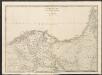
Lower Egypt
A new general atlas of modern geography, consisting of a complete collection of maps of the four quarters of the globe Wyld, James James Wyld