Maps of Beheira Governorate
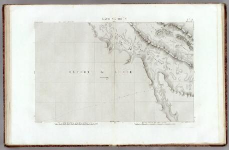
26 Lacs Natroun.
1 : 100000 Jacotin, Pierre, 1765-1827
Plan of the Operations of the British & Ottoman Forces in Egypt, From the 8th. of March to the 2d. of Sept.r 1801, when the French were Finally expelled from that Country
Neele, Samuel John Arrowsmith
Cairo [Provisional map of the country North-west ] (1915)
Provisional map of the country north-west of Cairo : including the Wadi Natrun. Egypt. Maṣlaḥat al-Misāḥah. [Cairo] : Survey of Egypt
28 Fleuve Sans Eau.
1 : 100000 Jacotin, Pierre, 1765-1827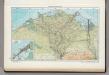
163. Nile Delta, Suez Canal, Alexandria. The World Atlas.
1 : 750000 USSR (Union of Soviet Socialist Republics).
Libyan Desert [Route survey in the northern part of] (1894)
Route survey in the northern part of the Libyan Desert by Capt. H G Lyons RE, April 1894, IDWO 1042. Covers part of Egypt from Wadi Natrun to Bahariya Oasis. Great Britain. War Office. Intelligence Division. [London] : [War Office, Intelligence Division].
Carte De L'Egypte et des Postes Militaires occupés et Fortifiés par les Français sous les ordres du Géneral en Chef Bounaparte, depuis leur invasion le 1. Juillet 1798, jusqu'à ce jour; Dressée d'après les relations fidelles des Chefs interceptées, et sur le compte qui en a eté rendu par les deserteurs
Kauffer, François
Aegypti Recentior Descriptio. [Karte], in: Theatrum orbis terrarum, S. 311.
1 Karte aus Atlas Ortelius, Abraham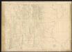
[Ägypten] [Karte], in: Gerardi Mercatoris Atlas, sive, Cosmographicae meditationes de fabrica mundi et fabricati figura, S. 499.
1 Karte aus Atlas Mercator, Gerhard Montanus, Petrus
Aegypti Recentio Descriptio. [Karte], in: Theatrum orbis terrarum, S. 120.
1 Karte aus Atlas Ortelius, Abraham
Lower Egypt, Palestine.
1 : 755000 Faden, William, 1750?-1836
Lower Egypt.
1 : 1000000 John Bartholomew & Co.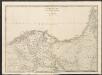
Lower Egypt
A new general atlas of modern geography, consisting of a complete collection of maps of the four quarters of the globe Wyld, James James Wyld
Feuille No. 7, uit: Carte de la Turquie d'Asie (moins l'Arabie) / dessiné et héliogravé au Service géographique de l'Armée
1 : 1000000 titelvariant: Turquie d'Asie; Annotatie: Titel boven de kaart: Turquie d'Asie; Bl. genummerd 1-4 en 7-10; Met lijst van de meest gebruikte woorden op de kaart vertaald uit het Turks, Arabisch en Perzisch; Annotatie geografische gegevens: Inzetkrt. op bl. 9: Plan de Jérusalem et de ses environs, Plan d'Alep, Plan de Damas et de ses faubourgs, Plan de Beyrout et de ses environs (alle 1:50.000) Service géographique de l'Armée [S.l. : Service géographique de l'Armée]
Egypt, Abyssinia.
Thomson, John
Die Nilländer...

Voyage des Israelites depuis leur sortie d'Egypte.
1 : 3000000 Houze, Antoine Philippe
Dolní Egypt
1 : 1000000 Egypt Král z Dobré Vody, Vojtěch Fr. Šimáček
Egypte geog. 3.
1 : 1000000 France. Armee. Genie; Jacotin, Pierre, 1765-1827
Nvova, et copiosa, descrittione di tutto l'Egitto
Egypt Forlani, Paolo da Paulo Forlani Veronese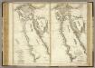
Ancient and Modern Egypt.
1 : 1950000 Playfair, Principal
Aegypti Recentior Descriptio. [Karte], in: Theatrum orbis terrarum, S. 412.
1 Karte aus Atlas Ortelius, Abraham Vrients, Jan Baptista
Egypt.
1 : 1270000 Pinkerton, John, 1758-1826
AEgyptus Antiqua.
1 : 2000000 Anville, Jean Baptiste Bourguignon d, 1697-1782
Egypt.
1 : 3400000 Finley, Anthony
[Unter Ägypten]
Egypt Brose, Wilhelm
U.A.R. (United Arab Republic) - Lower Nile Valley. (Egypt) Pergamon World Atlas.
1 : 2500000 Polish Army Topography Service
Nile Delta and Sinai, Plate 86, V. IV
1 : 1250000 Bartholomew, John
L'Egypte.
1 : 2150000 Bonne, Rigobert, 1727-1794