Maps of Canada
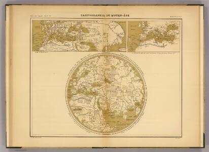
Cartographie du Moyen-Age.
Mauro, fra
America.
1 : 26000000 Arrowsmith, John
A new projection of the Eastern Hemisphere of the earth on a plane, shewing the proportions of its several parts nearly as on a globe
1 : 100000000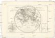
Mappe-monde sur le plan d'un méridien
Afrika André
CHARTE von AMERICA
Amerika
Westliche halb Kugel
1 : 45000000 Amerika Anville, Jean-Baptiste Bourguinon d' Benedicti, Hieronymus im I.G. Trasslerischen Verlage
Westliche halb Kugel
1 : 45000000 Amerika Anville, Jean-Baptiste Bourguinon d' Benedicti, Hieronymus im I.G. Trasslerischen Verlage
Westliche halb Kugel
1 : 45000000 Amerika Anville, Jean-Baptiste Bourguinon d' Benedicti, Hieronymus im I.G. Trasslerischen Verlage
Westliche Halb Kugel
Amerika Anville, Jean-Baptiste Bourguinon d' Benedicti, Hieronymus von F.A. Schrämbl
Westliche halb Kugel
1 : 45000000 Amerika Anville, Jean-Baptiste Bourguinon d' Benedicti, Hieronymus im I.G. Trasslerischen Verlage
AMERICAE Aucta DELINEATIO
Amerika
Eastern Hemisphere.
1 : 85000000 Johnson, A.J.
America
1 : 27400000 Amerika Weiland, Karl Ferdinand Kratz, E. F. m Verlage des Geograph. Instituts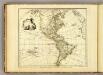
America.
1 : 50000000 Faden, William, 1750?-1836
America (blank)
1 : 50000000 Faden, William, 1750?-1836
Západnj polokaule
Amerika Merklas, Václav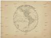
Západnj polokaule
Amerika Merklas, Václav
Západnj polokaule
Amerika Merklas, Václav
Západnj polokaule
Amerika Pluth Merklas, Václav
Asia.
1 : 39413000 Hammond, C.S.
America / gezeichnet von F. v. Stülpnagel, 1843; gest. v. W. Behrens.
from Whole von F. v. Stülpnage; W. Behrens,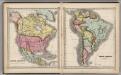
North America. South America.
1 : 27000000 Schonberg & Co.
America.
1 : 54000000 Melish, John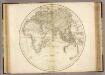
Eastern Hemisphere.
1 : 45000000 Playfair, Principal
Mer des Indes.
1 : 70000000 Buache, Philippe, 1700-1773
Carte d'Amerique divisées en ses principales parties
1 Karte : Kupferdruck ; 47 x 57 cm L'Isle; Anville; Condet chez Cóvens & Mortier & Cóvens junior
Composite: North and South America
1 : 1641836 Vandermaelen, Philippe, 1795-1869
America
1 : 29000000 Amerika Weiland, Karl Ferdinand Geographisches Institut
America.
1 : 39000000 Stulpnagel, F.v.