Maps of Fort Thomas

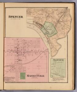
Spencer; Madisonville.
Harrison, Robert H.; Titus, Clarence O.
Cincinnati 7, wards 17, 20.
1 : 3600 Harrison, Robert H.; Titus, Clarence O.
Upper Ohio River and Valley part XXVI, 452 to 467 miles below Pittsburgh, from Cincinnati to 15 miles above.
1 : 31680 Hayes, Eli L.
East Cincinnati
1 : 62500
East Cincinnati
1 : 62500
East Cincinnati
1 : 62500
East Cincinnati
1 : 62500
East Cincinnati
1 : 62500
Cincinnati & suburbs.
1 : 17500 M. & R. Burgheim (Firm)
Newport
1 : 24000
Newport
1 : 24000
Newport
1 : 24000
Newport
1 : 24000
Newport
1 : 24000
Newport
1 : 24000
Newport
1 : 24000
Anderson.
1 : 31680 Harrison, Robert H.; Titus, Clarence O.
Cincinnati.
1 : 32000 Rand McNally and Company
Cincinnati, Ohio and vicinity.
1 : 21000 Hayes, Eli L.
Cleveland. Cincinnati.
Rand McNally and Company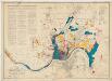
Official city plan map Cincinnati, Ohio
1 : 24000 Technical Advisory Corporation (New York, N.Y.) Technical Advisory Corp.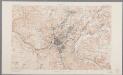
Ohio-Kentucky, Cincinnati quadrangle : topography / geo[graphy] T. Hawkins and W.J. Peters ; topography by Chas. E. Cooke
1 : 62500 Annotatie geografische gegevens: Opname: 1898, herzien in 1912 (bebouwing) Hawkins, T.; Peters, W. J.; Cooke, Chas. E. [Washington, D.C. : U.S. Geological Survey]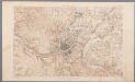
[Recto], uit: Ohio-Kentucky, Cincinnati quadrangle : topography / geo[graphy] T. Hawkins and W.J. Peters ; topography by Chas. E. Cooke
1 : 62500 Annotatie geografische gegevens: Opname: 1898 Hawkins, T.; Peters, W. J.; Cooke, Chas. E. [Washington, D.C. : U.S. Geological Survey]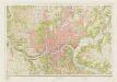
Cincinnati and vicinity : Ohio --Ky
1 : 24000 Geological Survey (U.S.) [Geological Survey]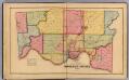
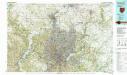
Hamilton County.
1 : 76032 Harrison, Robert H.; Titus, Clarence O.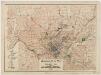
Regional plan map of Cincinnati, Ohio
1 : 62500 Technical Advisory Corporation (New York, N.Y.) Technical Advisory Corp.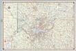
Shell Metropolitan Cincinnati and Vicinity.
1 : 139392 Shell Oil Company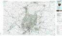
Cincinnati
1 : 100000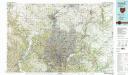
Cincinnati
1 : 100000