Maps of Peloponnese, West Greece and Ionian Sea
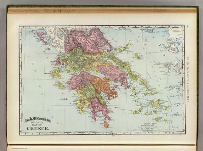
Greece.
1 : 1470000 Rand McNally and Company
Griechenland und die Jonischen Inseln
Schul-Atlas in 36 Karten Völter, Daniel Verlag der J.M. Dannheimer'schen Buchhandlung
Griechenland
1 : 2300000 Řecko F. A. Brouckaus' Geogr.-artist. Anstalt
Greece And The Ionian Republic.
1 : 1584000 Colton, G.W.
Griechenland.
1 : 1400000 Flemming, Carl
Graeciae antiquae et adjacentis partim Asiae Minoris tabula geographica
1 : 2810000 Malá Asie Berra, Marco Marco Berra
Griechenland und die Jonischen Inseln mit Beachtung der Klassischen Zeit
Hand-Atlas über alle Theile der Erde nach dem neuesten Zustande und über das Weltgebäude Stieler, Adolf bei Justus Perthes
Griechenland und der Griechisch-Türkische Archipel
Handatlas über alle Theile der Erde und über das Weltgebäude Stieler, Adolf Justus Perthes
Greece and the Ionian Republic.
1 : 2000000 Colton, G.W.
Königreich Griechenland
1 : 1600000 nach den neuesten und besten Hülfsmitteln entworfen und gezeichnet von C.F. Weiland. Weimar : im Verlage des Geograph. Instituts
Griechenland
Stieler's Hand-Atlas Stieler, Adolf bei Justus Perthes
Griechenland Und Der Griechisch-Turkische Archipel.
1 : 1850000 Petermann, A.
Greece and the Ionian Republic.
1 : 2000000 Colton, G.W.
Charte von dem Koenigreiche Griechenland nebst Theilen der angraenzenden Laender des Osmanischen Reiches im Europa und Asien
1 : 1000000 Kréta (Řecko) Cotta, Johann Georg litterar.ch-artistisch.en Anstalt der J.G. Cotta'schen Buchhandlung
[Geschichtlich-geographischer Atlas von Europa :] I. Karte von Alt-Griechenland
entworfen und gezeichnet durch Ferd. Aug. v. Witzleben Gestochen bei K. Kolbe von Leop. Müller [Berlin etc.] : [Mittler]
Greece and the Ionian Republic.
1 : 1500000 Colton, G.W.
Greece and the Ionian Republic.
1 : 1500000 Colton, G.W.
[Griechenland]
1 : 1000000 Athény (Řecko : oblast)
Das Königreich Hellas
1 : 1000000 Řecko Bosse, P. Debes, E. Geograph. Anstalt von Wagner & Debes
Greece.
1 : 1425000 Teesdale, Henry
Ancient Greece.
1 : 2500000 Mitchell, Samuel Augustus
Königreich Hellas oder Griechenland
1 : 1000000 Athény (Řecko : oblast) Kiepert, Heinrich Dietrich Reimer
Ancient Greece.
1 : 1720000 Teesdale, Henry
[Kaart], uit: Geofusikos chartēs tēs Ellados
1 : 1000000 Annotatie: Met 5 thematische kaartjes Athēnai : Nik. Alikiotē
Griechenland
1 : 3000000 Foiníkie Eduard Hölzel
Hellas, Ionischen Inseln.
1 : 800000 Kiepert, Heinrich, 1818-1899
82-83. Grecia.
1 : 1500000 Touring club italiano
Graecia Antiqua
1 : 2900000 Mellish, John
Griechenland und die Jonischen Inseln mit Beachtung der Klassischen Zeit
Hand-Atlas über alle Theile der Erde nach dem neuesten Zustande und über das Weltgebäude Stieler, Adolf bei Justus Perthes