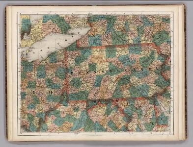
Maps of Allegheny Plat.

Ohio, Pennsylvania, New York, Maryland.
1 : 1584000 Smith, J. Calvin
Virginia and Maryland / By H. Moll, geographer.
from Parts
The tourist's pocket map of Pennsylvania : exhibiting its internal improvements, roads, distances &c. / by J.H. Young ; D. Haines, sc.
from Whole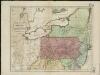
Map of the middle states of America, comprehends New-York, New-Jersey, Pennsylvania, Delaware, and the territory N.W. of Ohio
Russell, John Symonds, Henry Delahoy
Bridge by which the South Mountain & Boston R.R. is to cross the Hudson River at Poughkeepsie, N.Y. ; The Map of South Mountain and Boston
from New illustrated atlas of Dutchess County, New York. / Compiled & drawn from personal examinations, surveys etc. under the personal supervision of O.W. Gray & Son and F.A. Davis, and published under the superintendence of H. L. Kochersperger.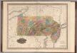
Pennsylvania and New Jersey.
1 : 1100000 Tanner, Henry S.
Map of Pennsylvania and New Jersey / by H.S. Tanner; engraved by H.S. Tanner & assistants.
from Parts Henry S. Tanner,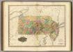
Map Of Pennsylvania And New Jersey.
1 : 1140480 Tanner, Henry S.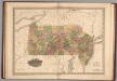
Pennsylvania and New Jersey.
1 : 1100000 Tanner, Henry S.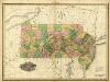
Pennsylvania and New Jersey.
1 : 1100000 Tanner, Henry S.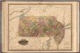
Pennsylvania and New Jersey.
1 : 1100000 Tanner, Henry S.
A map of the canals & rail roads of Pennsylvania and New Jersey, and the adjoining states / by H.S. Tanner; engraved by H.S. Tanner & assistants.
from Parts Henry S. Tanner,
A map of the canals & rail roads of Pennsylvania and New Jersey and the adjoining states / by H. S. Tanner; engraved by H.S. Tanner & assistants.
from Parts Henry S. Tanner,
Pennsylvania.
1 : 2724480 Scott, Joseph
Pennsylvania.
1 : 2175000 Schonberg & Co.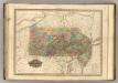
Pennsylvania and New Jersey.
1 : 1120000 Tanner, Henry S.
Pennsylvania.
from Whole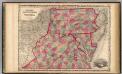
Pennsylvania And Virginia.
1 : 1520640 Johnson, A.J.
[Neueste Karte von Pennsylvania mit seinen Canaelen, Eisenbahnen und c.]
Grosser Hand-Atlas über alle Theile der Erde in 170 Karten Meyer, J. Verlag des Bibliographischen Instituts
Pennsylvania and New Jersey.
1 : 1280000 Asher & Adams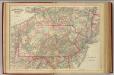
Penn., N.J.
1 : 1267200 Asher & Adams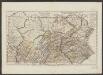
Pennsylvania
1 : 750000 Sotzmann, D. F Bey Carl Ernst Bohn
Northern or Middle States.
1 : 3000000 Cornell, S. S. (Sarah S.)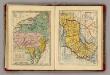
Middle & Southern States.
Goodrich, S.G.
Neu York, Pennsylvanien u. Neu Jersey.
1 : 3400000 Lange, Henry, 1821-1893.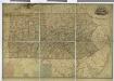
Map of Pennsylvania / constructed from the county surveys authorized by the state, and other original documents ; revised and improved under the supervision of Wm. E. Morris, civil engineer, upon data procured in each county ; engraved by Edwd. Yeager.
from Whole
Schonberg's Map of Pennsylvania, New Jersey, Maryland and Delaware.
1 : 1900000 Schonberg & Co.
Map of Virginia and Maryland, constructed from the latest authorities / J.H. Young sc.
from Parts
A map of the canals & rail roads of Pennsylvania and New Jersey, and the adjoining states / by H.S. Tanner; engraved by H.S. Tanner & assistants.
from Parts Henry S. Tanner,