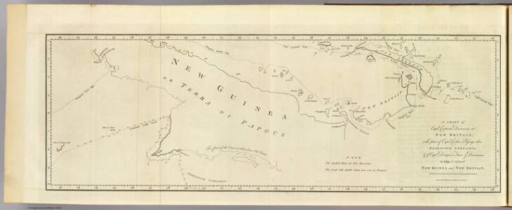
Maps of New Guinea
New Britain discoveries.
1 : 4500000 Hawkesworth, John, 1715?-1773
Die deutschen Besitzungen im Stillen Ozean
1 : 3000000 Kiepert, Richard Geographische Verlagshandlung Dietrich Reimer
Kaiser-Wilhelmsland

Západní Irian

Nederlands Nieuw-Guinea / [Netherlands Topographic Service]
Netherlands Topographic Service Delft [Delft : Netherlands Topographic Service]
Nederlandsch-Nieuw-Guinee
Topographische Inrichting Batavia Batavia : Top[ographische] Inr[ichting]
Kaart van Nederlandsch Nieuw-Guinea en omliggende eilanden / Topographisch Bureau
Topographisch Bureau Batavia Batavia : Topographisch Bureau
Kaart van een gedeelte der zuid en zuidwest kust van Nieuw-Guinea : volgens de opnemingen gedaan door Zr. Ms. schepen Dourga, Triton, Sireen en Postillon tusschen de jaren 1826 en 1835 / zamengesteld door Salomon Müller
[S.l. : s.n.]
Ambunti / U.S. Army Map Service
U.S. Army Map Service Washington D.C. Washington D.C. : U.S. Army Map Service
Aroe-Eilanden / samengesteld en gedrukt bij den Topografischen Dienst
Topografische Dienst Batavia Batavia : Topografische Dienst
Aroe Eilanden / U.S. Army Map Service
U.S. Army Map Service Washington D.C. Washington D.C. : U.S. Army Map Service
Languages of the Sepic Region, Papua New Guinea / D. Laycock
Australian National University Canberra [Canberra] : Australian National University
Geologische overzichtskaart van den Nederlandsch Oost-Indischen Archipel : Nederlandsch Nieuw Guinea [Zuid] / bewerkt door J. Zwierzycki
Landsdrukkerij Weltevreden (Batavia) [Weltevreden (Batavia) : Landsdrukkerij]
Geologische overzichtskaart van den Nederlandsch Oost-Indischen Archipel : Aroe-, Kei- en Tenimbereilanden / bewerkt door J. Zwierzycki
Landsdrukkerij Weltevreden (Batavia) [Weltevreden (Batavia) : Landsdrukkerij]
Partie, Nouvelle Guinee. Oceanique no. 30.
1 : 1641836 Vandermaelen, Philippe, 1795-1869
Partie, Nouvelle Guinee. Oceanique no. 31.
1 : 1641836 Vandermaelen, Philippe, 1795-1869
Partie, Nouvelle Guinee. Oceanique no. 23.
1 : 1641836 Vandermaelen, Philippe, 1795-1869
Iles de l'Amiraute. Oceanique no. 24.
1 : 1641836 Vandermaelen, Philippe, 1795-1869
Kaart van Nederlandsch Nieuw Guinea en de Papoesche Eilanden
[S.l. : s.n.]
Languages : Eastern, Western and Southern Highlands Territory of Papua and New Guinea / by S.A. Wurm
[S.l. : Australian National University]
Languages : Eastern, Western and Southern Highlands Territory of Papua and New Guinea / by S.A. Wurm
[Canberra : Australian National University]
[Deel van de onderafdeling Fak-Fak met zuidelijk deel van de Vogelkop] / prepared under the direction of the Chief Engineer by Base Map Plant U.S. Army
Corps of Engineers U.S. Army War Department Washington D.C. [Washington D.C.] : Corps of Engineers U.S. Army, War Department
Schetskaartje van een gedeelte der Westkust van Nieuw Guinea / door W.F. Versteeg
Nederlandsch Aardrijkskundig Genootschap Amsterdam Amsterdam : C.L. Brinkman
Vogelkop
[S.l. : s.n.
Schetskaart van het Bomberai-Gebied
[Hollandia] : Kadaster en Katering
Bladwijzer van Merauke en omgeving
[S.l. : s.n.]
Aroe Islands / Australian Survey Corps
Australian Survey Corps [S.l.] : Australian Survey Corps
Wilhelmina-Top / Netherlands Topographic Service
Netherlands Topographic Service Delft [Delft] : Netherlands Topographic Service
Bian-Rivier / prepared and reproduced by Base Map Plant USASOS SWPA, December 1942 - January 1943, from a Dutch map printed by Topografische Dienst (Topographic Service) Batavia, 1941
Base Map Plant USASOS SWPA [S.l.] : Base Map Plant USASOS/SWPA