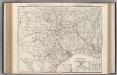
Maps of Louisiana

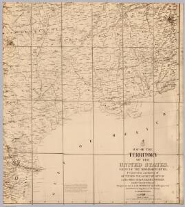
U.S. West of Mississippi R. 6.
1 : 2000000 Freyhold, Edward; Warren, Gouverneur Kemble, 1830-1882; United States. Army. Corps of Engineers
Map of the United States of North America / compiled from the latest and most authentic information by David H. Vance ; engraved by J.H. Young.
From Whole
La Floride: suivant les nouvelles observations de Messrs. de l'Academie royale des sciences, etc. augmentées de nouveau. / A Leide, Chez Pierre Vander A.A., avec privilege.
from John H. Levine Collection Pierre Vander A.A.,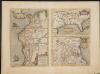
La Florida. Auctore Hieron Chiaves.
When first issued in 1584 as a copper engraving by Ortelius in his Theatrum Orbis Terrarum 1584-1612, this was one of the few sixteenth century maps based on Spanish sources; in this case drawn from reports of Hernando de Soto's expedition through the region. There are three maps on this sheet. The most important map (La Florida) is the first printed map of the southeastern portion of the United States. This influential map provided the foundation cartography for the region, particularly in the depiction of the river system. The map below (Guastecan Reg) combines with La Florida to extend the coastline of the Gulf of Mexico further south. The third is a map of Peru, where De Soto was the first Spaniard to meet Inca Emperor Atahuallpa. In the north of the map of Peru is Aurea Regio, or Kingdom of Gold, a reference to the fabled El Dorado. Text on verso. Chaves, Geronimo, 1523-1574.;Ortelius, Abraham, 1527-1598. Ortelius, Abraham, 1527-1598.
Texas. Kentucky. Tennessee.
1 : 3743000 Gray, Ormando Willis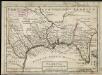
Florida called by ye French Louisiana &c.
1 : 150000 Moll, Herman Bowles, Thomas
108. Sugar, molasses.
1 : 18000000 Gannett, Henry, 1846-1914; Hewes, Fletcher W.; United States. Census Office
United States ... South Central Section.
1 : 2851200 Fullarton, A. & Co.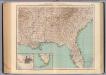
145-46. Ark., Tenn., La., Miss., Fla., Ala., Ga., S.C.
1 : 3000000 Touring club italiano
A New Map Of Texas, With The Contiguous American & Mexican States.
1 : 4752000 Young, James H.
Map of Louisiana, Mississippi, and Arkansas.
from New general atlas.
Soil Map of the United States, Section 10. Atlas of American Agriculture.
1 : 2500000 Marbut, Curtis F.
Intl. & Gt. N. Railroad.
1 : 3261700 Rand McNally and Company
Texas Short Line.
1 : 3400000 St. Louis, Iron Mountain, and Southern Railway Company
Die Staaten von Arkansas, Mississippi, Louisiana und Alabama
AutoTrails Map, Texas, Oklahoma, Louisiana, Arkansas.
1 : 1951000 Rand McNally and Company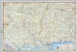
Shell Sectional Map No. 8 - Gulf States.
1 : 1710720 Shell Oil Company
Mississippi, Louisiana, and Arkansas.
1 : 3623775 Fisher, Richard Swainson
Sheet 3: United States of Nth. America.
1 : 1584000 Tardieu, P.F.
United States.
1 : 3380000 Sharpe, J.
Vereinigte Staaten Von Nord-Amerika In 6 Blattern, Bl. 5.
1 : 3700000 Petermann, A.
206-207. United States of America, South Central. The World Atlas.
1 : 2500000 USSR (Union of Soviet Socialist Republics).
Mississippi Territory.
from Carey's general atlas, improved and enlarged : being a collection of maps of the world and quarters, their principal empires, kingdoms, &c.
Alabama, Arkansas, Louisiana, and Mississippi.
1 : 3000000 Lloyd, H.H.
Alabama, Arkansas, Louisiana, and Mississippi.
1 : 3000000 Walling, H. F.
Shell Highway Map of Arkansas-Louisiana, Mississippi.
1 : 1457280 Shell Oil Company
Ala., Miss., La., Ark.
1 : 4700000 Grigg, John
Texas.
1 : 4700000 Greenleaf, Jeremiah
Wisconsin and Iowa.
1 : 4000000 Greenleaf, Jeremiah