Maps of Northern European Plain
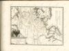
Russie occidentale.
1 : 8700000 Robert de Vaugondy, Gilles, 1688-1766
Les états du czar ou empereur des russes en Europe et en Asie, avec les routes qu'on tient ordinair
1 : 9000000 1 Karte : Kupferdruck ; 42 x 65 cm Fer, Nicolas de chez I.F. Benard, gendre du S. de Fer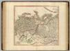
Russian Empire west.
1 : 9400000 Cary, John, ca. 1754-1835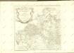

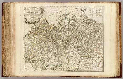
Nouvelle carte de Moscovie où sont representés les diferents etats de Sa Maiesté Czarienne en Eur
1 : 13000000 1 Karte : Kupferdruck ; 40 x 56 cm Châtelain, Zacharias [Verlag nicht ermittelbar]
Nouvelle carte de Moscovie où sont representés les diferents etats de Sa Maiesté Czarienne en Eur
1 : 13000000 1 Karte : Kupferdruck ; 40 x 56 cm Châtelain, Zacharias [Verlag nicht ermittelbar]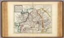
Great Tartary.
1 : 26000000 Moll, Herman, d. 1732
Russie D'Europe, Empire Russe.
Andriveau-Goujon, J.
Carte de Tartarie / dressée sur les relations de plusieurs voyageurs de differentes nations et sur
1 : 11100000 1 Karte : Kupferdruck ; 47 x 60 cm L'Isle, Guillaume de chez I. Cóvens et C. Mortier
Carte de Tartarie / dressée sur les relations de plusieurs voyageurs de differentes nations et sur
1 : 11100000 1 Karte : Kupferdruck ; 47 x 60 cm L'Isle, Guillaume de chez I. Cóvens et C. Mortier
Imperium Russicum
1 : 7600000 Rusko Doetsch, Johann Anton Hartl, Sebastian apud Sebastianum Hartl
An accurate map of the Russian empire both in Europe and Asia / Engraved for Guthries new System of
1 : 19000000 1 Karte : Kupferdruck ; 32 x 40 cm Dilly, Charles Published as the Act directs by C. Dilly & G. Robinson
Uebersichts-Karte der ethnographischen Verhältnisse von Asien und von den angrenzenden Theilen Europa'sbearbeitet und herausgegeben mit Unterstützung der kaiserlichen Akademie der Wissenschaften in Wien von Vinzenz v. Haardt
Hartenthurn, Vincenz
Russie occidentale.
1 : 13000000 Bonne, Rigobert, 1727-1794

Generali totius imperii Russorum novissima tabula
1 : 11940000 Japonské moře Homann, Johann Baptist ex conatibus Iohannis Baptistae Homanni
Sovětský svaz v mapách
Carte de la Sibérie et des pays voisins / par le Sr. Bellin Ing. de la Marine
1 : 14500000 1 Karte : Kupferdruck ; 27 x 44 cm Bellin, Jacques Nicolas [Bellin]
Carte de la Sibérie et des pays voisins / par le Sr. Bellin Ing. de la Marine
1 : 14500000 1 Karte : Kupferdruck ; 27 x 44 cm Bellin, Jacques Nicolas [Bellin]
Carte de la Sibérie et des pays voisins / par le Sr. Bellin Ing. de la Marine
1 : 14500000 1 Karte : Kupferdruck ; 27 x 44 cm Bellin, Jacques Nicolas [Bellin]
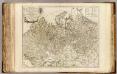
Carte generale des etats du Czar empereur de Moscovie, ou l'on voit ce que ce prince possede en Euro
1 : 9500000 1 Karte auf 2 Blatt : Kupferdruck ; 36 x 62 cm Châtelain, Zacharias L'Honore et Châtelain
Partie occidentale de l'empire de Russie / projetée et assujetie aux observations astronomiques pos
1 : 13000000 1 Karte : Kupferdruck ; 42 x 31 cm Bonne, Rigobert chez Lattré ruë St. Jacques à la ville de Bordeaux
[Rusko]
1 : 9740000 Rusko
Russie d'Europe avec la partie la plus peuplée de celle d'Asie / par le S.r Janvier, géographe
1 : 11500000 1 Karte : Kupferdruck ; 30 x 44 cm Janvier, Jean chez Lattré graveur
W. Siberia, Tartary, Khiva, Bokhara &c.
1 : 10060000 Society for the Diffusion of Useful Knowledge (Great Britain)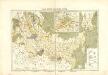
Atlas für Industrie- und Handelsgeographie: Für commercielle und technische Lehranstalten, für Kaufleute und Industrielle

La parte occidentale della Russia asiatica / Gio. Ma. Cassini som. inc.
1 : 12000000 1 Karte : Kupferdruck ; 31 x 44 cm Cassini, Giovanni Maria Presso la Calcografia Camerale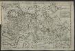
Nouvelle carte de l'empire du Czar de la Grande-Russie
Russland Moll, Hermann