Maps of United Kingdom
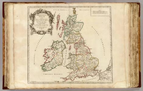
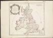
Britannicae Insulae.
1 : 2300000 Sanson, Nicolas, 1600-1667
Les Isles Britanniques, qui comprennent les Royaumes d'Angleterre, d'Ecosse et d'Irlande
1 : 2000000
ANGLIAE SCOTIAE et HIBERNIAE Regna
Anglie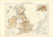
Atlas für Industrie- und Handelsgeographie: Für commercielle und technische Lehranstalten, für Kaufleute und Industrielle

MAGNAE BRITANNIAE TABULA
1 : 3170000 Anglie Visscher, Nicolaes Jansz. per Nicolaum Visscher
Nieuwe kaart van de eilanden van Groot Brittannien : behelzende de koningryken Engeland, Schotland en Ierland / volgens de laatste waarnemingen in het ligt gebragt ; C. Sepp del. et sculps. 1743
1 : 3500000 Annotatie: Oorspr. verschenen in: Nieuwe hand-atlas ... - Amsterdam : Isaak Tirion, 1744 Sepp, C. Te Amsterdam : by Isaak Tirion
Les Isles Britanniques
Britannicae Insulae in quibus Albion seu Britannia Major, et Ivernia seu Britannia Minor ...
1 : 2300000
58-59. Great Britain and Ireland. The World Atlas.
1 : 2500000 USSR (Union of Soviet Socialist Republics).
Nieuwe en perfeckte caerte van Engelandt, Schotlandt en Yerlandt
1 : 2470000 [Amsterdam] : nieuwelijck uyt gegeven bij Hugo Allardt, in de Calverstraet inde Werrelt Caert
Neueste Karte von Grossbritannien und Jreland
Grosser Hand-Atlas über alle Theile der Erde in 170 Karten Meyer, J. Verlag des Bibliographischen Instituts

Anglia, Scotia et Hibernia. [Karte], in: Gerardi Mercatoris Atlas, sive, Cosmographicae meditationes de fabrica mundi et fabricati figura, S. 82.
1 Karte aus Atlas Mercator, Gerhard Montanus, Petrus
Anglia, Scotia et Hibernia. [Karte], in: Atlas, sive, Cosmographicae meditationes de fabrica mundi et fabricati figura, S. 80.
1 Karte aus Atlas Mercator, Gerhard
Magnae Britanniae et Hiberniae Tabula
1 : 2300000
Magnae Britanniae et Hiberniae Tabula. [Karte] Orcades Insulae [Nebenkarte], in: Gerardi Mercatoris et I. Hondii Newer Atlas, oder, Grosses Weltbuch, Bd. 1, S. 51.
1 Karte aus Atlas Mercator, Gerhard und Hondius, Jodocus Jansson, Jan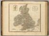
British Isles.
1 : 2550000 Cary, John, ca. 1754-1835
Les Isles Britanniques : ou sont le royaumes d'Angleterre tiré de Speed, celuy d'Ecosse tiré de Th. Pont et celuy d'Irlande tiré de Petit / le tout rectifié par diverses observations par G. de l'Isle
1 : 2650000 titelvariant: Magnae Britanniae tabula; Annotatie: Titel boven de kaart: Magnae Britanniae tabula : comprehendens Angliae, Scotiae, ac Hiberniae regna, ad usum serenissimi Burgundiae Ducis; Oorspr. verschenen in: Atlas nouveau ... / par Guillaume de l'Isle. - Amsterdam : Jean Covens & Corneille Mortier, 1730 Isle, Guillaume de l' Amsteldam : I. Covens & C. Mortier
LES ISLES BRITANNIQUES
1 : 2500000 Anglie Jaillot, Alexis-Hubert H. Iaillot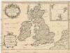
Les isles Britanniques
1 : 2600000 Anglie Sanson, Guillaume Boazius, I.B. chez H. Iaillot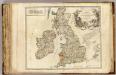
Iles Britaniques routes.
1 : 2075000 Robert de Vaugondy, Gilles, 1688-1766
Die Brittischen Inseln
Schul-Atlas über alle Theile der Erde nach dem neuesten Zustande, und über das Weltgebäude Stieler, Adolf Justus Perthes
Magnae Britanniae et Hiberniae Nova Descriptio [Karte] Orcades Insulae. [Nebenkarte], in: Novus atlas absolutissimus, Bd. 7, S. 29.
1 Karte aus Atlas Janssonius Offizin
Magnae Britanniae et Hiberniae Tabula [Karte] Orcades Insulae [Nebenkarte], in: Novus Atlas, das ist, Weltbeschreibung, Bd. 3, S. 358.
1 Karte aus Atlas Blaeu, Joan Blaeu, Willem Janszoon
Magnae Britanniae et Hiberniae Tabula [Karte] [Orcades Insulae] [Nebenkarte], in: Theatrum orbis terrarum, sive, Atlas novus, Bd. 4, S. 16.
1 Karte aus Atlas Blaeu, Joan Blaeu, Willem Janszoon
La grande Bretagne ou les Royaumes d'Angleterre et d'Ecosse comme aussi le Royaume d'Irlande
1 : 2300000 Anglie Lotter, Matthäus Albrecht T. C. Lotter
Magnae Britanniae et Hiberniae Tabula [Karte] [Orcades Insulae] [Nebenkarte], in: Theatrum orbis terrarum, sive, Atlas novus, Bd. 4, S. 16.
1 Karte aus Atlas Blaeu, Joan Blaeu, Willem Janszoon
Regnorum Magnae Britanniae et Hiberniae mappa geographica
1 : 2500000 Irsko Mayer, Tobias Homan[n]ianis Heredibus
REGNORVM MAGNAE BRITANNIAE ET HIBERNIAE MAPPA GEOGRAPHICA
1 : 2500000 Flandry Mayer, Tobias edentib[us] Homan[n]ianis Heredibus