Maps of United States

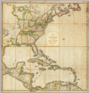
A Correct Map of the United States.
1 : 4850000 Lewis, Samuel
Amerikanisch-Spanischer kriegsschauplatz
1 : 7500000
A map of the British Empire in America: with the French, Spanish and Hollandish settlements adjacent thereto / by Henry Popple; I. Condet s.
from John H. Levine Collection Henry Popple; I. Condet s.,
Amerique septentrionale: suivant la carte de Pople faite à Londres en 20 feuilles.
from Charts and maps Par et chez le Sr. le Rouge ...: Paris; Lawson, Oscar A.; Le Rouge, Georges-Louis,
America Septentrionalis A Map of the British Empire in America.
1 : 11000000 Popple, Henry
Composite: British Empire in America.
1 : 2000000 Popple, Henry
Amerikanisch-spanischer Kriegsschauplatz
1 : 7500000 Habenicht, Hermann Justus Perthes
America Septentrionalis. A Map of the British Empire in America.
1 : 11000000 Popple, Henry
Composite: A Map of the British Empire in America.
1 : 2000000 Popple, Henry
Carte générale de l'Amérique séptentrionale: avec les posséssions Angloises dans cette partie du nouveau monde / dressée sur la carte de Pople [sic], publiée à Londres en 20 feuilles, pour servir à l'intelligence de la guerre présente.
from Whole Henry Popple,
Composite: North America, West India Islands.
1 : 5300000 Pownall, Thomas
A new map of North America with the West India Islands: divided according to the preliminary articles of peace, signed at Versailles, 20, Jan. 1783; wherein are particularly distinguished the United States and the several provinces, governments & ca. which compose the British dominions / laid down according to the latest surveys and corrected from the original materials of Goverr. Pownall, Membr. of Parliamt., 1783.
from Charts and maps Governor Pownall,
Composite: North America.
1 : 5400000 Robert Laurie & James Whittle
Regni Mexicani seu Novae Hispaniae, Floridae, Novae Angliae, Carolinae, Virginiae et Pensylvaniae necnon insularum archipelagi Mexicani in America Septentrionali
from Charts and maps
Composite: Amerique Septentrionale.
1 : 6300000 Anville, Jean Baptiste Bourguignon d, 1697-1782
Composite: North America.
1 : 5400000 Jefferys, Thomas
A new map of the north parts of America claimed by France under ye names of Louisiana, Mississipi, Canada and New France, with ye adjoyning territories of England and Spain ... / ... laid down according to the newest and most exact observations by H. Mol
from The world described, or, A new and correct sett of maps : shewing the kingdoms and states in all the known parts of the earth, with the principal cities, and most considerable towns in the world ... / ... by Herman Moll, geographer ...

Regni Mexicani seu Novae Hispaniae, Ludovicianae, N. Angliae, Carolinae, Virginiae, Pensylvaniae, ... in America Septentrionali
from John H. Levine Collection
A map of Florida and ye Great Lakes of Canada / by Robt. Morden.
from Atlas terrestris / by Robt. Morden.
Map of the United States of North America / compiled from the latest and most authentic information by David H. Vance ; engraved by J.H. Young.
from Whole
Central America.
1 : 16600000 Sharpe, J.
Map of the United States of America, the British Provinces, Mexico, the West Indies and Central America, with part of New Granada and Venezuela
1 : 6400000 Colton, George Woolworth Colton, J. H. (Joseph Hutchins)
Depths and temperatures observed in the western part of the North Atlantic Ocean
1 : 7000000 United States Coast Survey U.S. Coast Survey
United States.
1 : 1500000 Smith, J. Calvin
[Map of the United States, showing the proposed railroad routes from coast to coast, with table of distances, etc.]
from Whole s.n.: [N.Y.?],
Map Of The United States Of America.
1 : 16526080 Colton, J. H.
Regni Mexicani seu Novae Hispaniae, Ludovicianae, N. Angliae, Carolinae, Virginiae, Pensylvaniae, necnon insvlarvm archipelagi Mexicani in America Septentrionali / accurata tabula exhibita a Ioh. Baptista Homanno.
from Parts John Baptista Homann, S.,
Regni Mexicani seu Novae Hispaniae, Ludovicianae, N. Angliae, Carolinae, Virginiae, Pensylvaniae, necnon insularum archipelagi Mexicani in America Septentrionali / accurata tabula exhibita à Ioh. Baptista Homanno.
from Charts and maps John Baptista Homann, S.,