Maps of Westchester County

Colton's driving & wheeling map of the country twenty five miles north of the city of New York.
1 : 73000 G.W. & C.B. Colton & Co.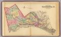
Outline map Westchester Co., N.Y.
1 : 109000 Bromley, George Washington; Bromley, Walter Scott; G.W. Bromley & Co.
Map of Westchester Co.
1 : 45000 G.W. Bromley & Co.
Plaines Blanches et Armees Americaine et Britannique, 12 Octobre1776.
1 : 130000 Marshall, John
Country from Frog's Point to Croton River shewing the American and British Armies 1776.
1 : 120000 Marshall, John
Birds Eye View Map Of New York And Vicinity.
1 : 80033 Hammond, C.S.
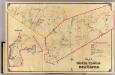
Plate 72: Town of North Castle, Westchester Co. N.Y.
from County atlas of Westchester, New York. Published by J.B. Beers & Co., assisted by S.W. Wilson and others.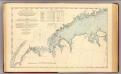
N.Y.-Norwalk Is.
1 : 80000 United States Coast Survey
A plan of the country from Frogspoint to Croton River shewing the positions of the American and British armies from the 12th of October 1776 until the engagement on the White Plains on the 28th
1 : 128400 Lewis, Samuel Wayne, Caleb Parry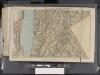
Westchester, Double Page Plate [Map of Westchester County, Irvington, Tarry Town to Sing Sing, East to State Line] / prepared under the direction of Joseph R. Bien, from general surveys and official records.
From Atlas of Westchester County, New York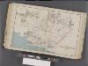
Westchester, Double Page Plate No. 17 [Map of Towns of White Plains, Harrison, and Rye] / prepared under the direction of Joseph R. Bien, from general surveys and official records.
From Atlas of Westchester County, New York
Westchester, Double Page Plate No. 13 [Map of Towns of Scarsdale, New Rochelle, and Mamaroneck] / prepared under the direction of Joseph R. Bien, from general surveys and official records.
From Atlas of Westchester County, New York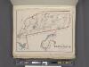
Westchester, Plate No. 28 [Map of Town of North Castle] / prepared under the direction of Joseph R. Bien, from general surveys and official records.
From Atlas of Westchester County, New York
31. Stamford sheet.
1 : 62500 Geological Survey (U.S.)
Tarrytown
1 : 62500
Tarrytown
1 : 62500
Tarrytown
1 : 62500
Tarrytown
1 : 62500
Tarrytown
1 : 62500
Tarrytown
1 : 62500
Tarrytown
1 : 62500
Tarrytown
1 : 62500
Tarrytown
1 : 62500
Tarrytown
1 : 62500
Town of Greenwich, Fairfield County, Connecticut.
1 : 38169 Beers, Frederick W.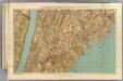
Westchester Co., Yonkers-state line.
1 : 31680 Bien, Joseph Rudolf; Vermeule, C. C. (Cornelius Clarkson), 1858-1950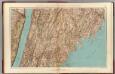
Westchester Co., Yonkers-state line.
1 : 31680 Vermeule, C. C. (Cornelius Clarkson), 1858-1950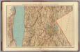
Westchester Co., Irvington-state line.
1 : 31680 Vermeule, C. C. (Cornelius Clarkson), 1858-1950
Map of Westchester Co.
1 : 45000 G.W. Bromley & Co.