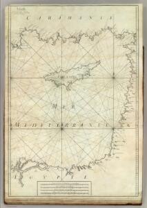
Maps of Levant Coast

Carte De La Mer Mediterranee. X.
Roux, Joseph
Syrien und die angraenzenden Laender zur Zeit der Kreuzzuge.
1 : 3000000 Spruner von Merz, Karl
Terre Sainte depuis la deuxieme croisade.
1 : 3300000 Houze, Antoine Philippe
La Palestine...

Terre Sainte, pendant la premiere croisade de 1096 a 1144.
1 : 3300000 Houze, Antoine Philippe
Syrie et de la Palestine, 624 ans apres J.C.
1 : 3300000 Houze, Antoine Philippe
Terre Sainte en 1839.
1 : 3300000 Houze, Antoine Philippe
Feuille No. 8, uit: Carte de la Turquie d'Asie (moins l'Arabie) / dessiné et héliogravé au Service géographique de l'Armée
1 : 1000000 titelvariant: Turquie d'Asie; Annotatie: Titel boven de kaart: Turquie d'Asie; Bl. genummerd 1-4 en 7-10; Met lijst van de meest gebruikte woorden op de kaart vertaald uit het Turks, Arabisch en Perzisch; Annotatie geografische gegevens: Inzetkrt. op bl. 9: Plan de Jérusalem et de ses environs, Plan d'Alep, Plan de Damas et de ses faubourgs, Plan de Beyrout et de ses environs (alle 1:50.000) Service géographique de l'Armée [S.l. : Service géographique de l'Armée]
Het oosterdeel van de Middelandsche Zee van 't eijland Rodus tot Ichanderoene
Cyprus Gerard van Keulen
La nvova et esatta descrittione della Soria, e della Terra Santa
Kypr Forlani, Paolo da Paulo Furlani Veronese
De beyde koningryken Juda en Israël, die na Salomo's dood zig van elkanderen afgescheurt hebben; benevens de overheerde landen aan elk dier beiden behorende
1 : 1400000 afgebeeldt door W.A. Bachiene J. van Jagen mapp. sculpsit, et figur. apposit. sculpturam curavit ; S. Fokke fec. Uitgegeven te Gorinchem : by Nicolaas Goetzee
Carte de la Terre Promise
1 : 1600000 Izrael
Abrahami patriarchae peregrinatio, et vita
1 : 2200000 Egypt Ortelius, Abraham Moflinius, Iohannes Abraham Ortelius
La Terre Sainte partagee en 12 tribus.
1 : 2800000 Houze, Antoine Philippe
Syria Phoenice, Syria Palaestina, Provinciae ab aerae Christianae anno 70 usque ad Diocletiani tempus; Phoenice, Coelesyria, Decapolis, Iudaea Herediadarum tempore.
1 : 2000000 Menke, Th.
PALAESTINA in XII. TRIBVS divisa, CVM TERRIS ADIACENTIBVS denuo revisa & copiosior reddita
1 : 1060000 Izrael Harenberg, Johann Christoph curantibus Homannianis Heredibus
Palaestina in XII. tribvs divisa, cvm terris adiacentibvs
1 : 1028000 Izrael Harenberg, Johann Christoph curantibus Homannianis Heredibus
Palaestina in XII. tribvs divisa, cvm terris adiacentibvs denuo revisa & copiosior reddita
1 : 1060000 Izrael Harenberg, Johann Christoph curantibus Homannianis Heredibus
Palestine sous Constantin le Grand, 330 apres J.C.
1 : 2750000 Houze, Antoine Philippe
La Terre Sainte sous Salomon.
1 : 2800000 Houze, Antoine Philippe
Palaestina seu Terra olim Sancta
Jordánské údolí (Jordánsko a Izrael) Harenberg, Johann Christoph ediderunt Heredes Homan[n]iani
PALAESTINA seu TERRA olim SANCTA
Jordánské údolí (Jordánsko a Izrael) Harenberg, Johann Christoph ediderunt Heredes Homan[n]iani
Iudaea seu Terra Sancta quae Hebraeorum sive Israelitarum in suas duodecim tribus divisa, secretis ab invicem regnis Iuda et Israel expressis insuper sex ultimi temporis ejusdem terrae provinciis
1 : 615000 Izrael Sanson, Guillaume Mortier, Pieter apud Petrum Mortier
Typus Chorographicus, Celebrium Locorum In Regno Iudae Et Israhel. [Karte], in: Theatrum orbis terrarum, S. 436.
1 Karte aus Atlas Ortelius, Abraham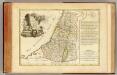
Douze Tribus d'Israel.
1 : 1030000 Bonne, Rigobert, 1727-1794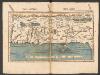
Tabula Moderna Terre Sancte [Karte], in: Claudii Ptolemei viri Alexandrini mathematice discipline philosophi doctissimi geographie opus [...], S. 272.
1 Karte aus Atlas Waldseemüller, Martin [und Ptolemaeus, Claudius] Übelin, Georg
Afbeelding van 't Joodsche land toen het aan de heerschappy der Romeinen onderworpen, met derzelver vergunning bestiert wierd, door koning Herodes den Groten, en deszelfs nageslagt : strekkende tot opheldering der geschiedenis van Christus
1 : 900000 door W.A. Bachiene J. van Jagen mapp. sculpsit, et figur. apposit. sculpturam curavit ; S. Fokke fecit. te Gorinchem : by Nicol: Goetzee
Royaume d'Herode.
1 : 2300000 Houze, Antoine Philippe