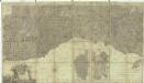
Maps of Riviera
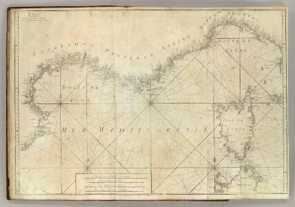
Carte De La Mer Mediterranee. III.
Roux, Joseph
IX, uit: General-Karte von Mittel-Europa in 12 Blättern, im Masse 1:1.200.000 / entworfen, bearb. und hrsg. von Josef Schlacher
1 : 1200000 Annotatie: Blad 6 ontbreekt; Annotatie geografische gegevens: 21 maatstokken op blad 9; Legenda op blad 9 Wien : K.K. Militär Geografisches Institut
France Flle. S.E.
1 : 1000000 Vivien St Martin, L.
Carte de la France, 4
1 Blatt : 61 x 83 cm de Belleyme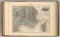
France S.E.
1 : 1615000 Migeon, J.
Carte de la France, 4
1 Blatt : mehrfarbig ; 61 x 82 cm de Belleyme
Frankreich SO.
1 : 1700000 Handtke, Friedrich H.
Carte de la République française, 4
1 Blatt : 42 x 51 cm P.G. Chanlaire
Carte de la France, 4
1 Blatt : 61 x 83 cm de Belleyme
[Frankreich in 4 Blättern, Blatt 4]
Handatlas über alle Theile der Erde und über das Weltgebäude Stieler, Adolf Justus Perthes
Nieuwe Paskaert van de Zee Kusten van Provence en Italiae
1 : 850000 Mollova mapová sbírka Keulen, Gerard van Keulen, Gerard van
Neueste Generalkarte von Frankreich, 6
1 Blatt : 55 x 78 cm F.A. Schrämbl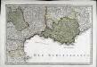
Sixieme feuille contenant le Languedoc, le Dauphiné, la Provence et le Roussillon
1 Blatt : 38 x 55 cm Bourgoin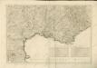
Carte de la république de France, no. 6
1 Blatt : 42 x 58 cm s.n.
[Frankreich, Blatt 4]
Adolf Stieler's Handatlas über alle Theile der Erde und über das Weltgebäude Stieler, Adolf Justus Perthes
Frankreich In 4 Blattern, Blatt 4.
1 : 1500000 Vogel, C.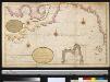
Afteekening van Provence en Italien tussen de C. Toulon en de Hoek van Piombino als ook de Noordkust van Corcia
France Gerard van Keulen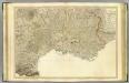
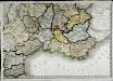
SE France.
1 : 700000 Faden, William, 1750?-1836
Toulon
1 : 750000 Toulon (Francie) K. k. militär-geographisches Institut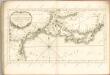

Übersichtskarte von Mittel - Europa

Franzosische Mittelmeerkuste, Paris, untere Seine.
1 : 1500000 Andree, Richard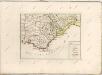

Provinciae, regionis Galliae, vera exactissimaque descriptio
1 : 234000
Weltkarte 1:1 000 000
1 : 1000000 OKH/Gen St d H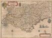
Provincia [...] Provence. [Karte], in: Novus Atlas, das ist, Weltbeschreibung, Bd. 2, S. 153.
1 Karte aus Atlas Blaeu, Joan Blaeu, Willem Janszoon
Provincia [...] Provence. [Karte], in: Le théâtre du monde, ou, Nouvel atlas contenant les chartes et descriptions de tous les païs de la terre, Bd. 2, S. 152.
1 Karte aus Atlas Blaeu, Willem Janszoon und Blaeu, Joan Blaeu, Willem Janszoon