Maps of Kommuneqarfik Sermersooq
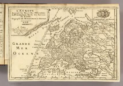
L'Europe.
1 : 26500000 Fer, Nicolas de, 1646-1720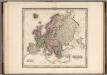
Europe.
1 : 11721600 Tanner, Henry S.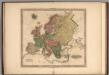
Europe.
1 : 11721600 Tanner, Henry S.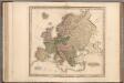
Europe.
1 : 11721600 Tanner, Henry S.
Europe.
1 : 11721600 Tanner, Henry S.
Tierra nveva.
from Charts and maps Sesssa?: [Venice]; Ruscelli, Girolamo; Gastaldi, Giacomo,
Ice Chart, Grand Banks Region, July.
U.S. Navy
Ice Chart, Grand Banks Region, October.
U.S. Navy
Drift Eis im Nordatlantischen Ocean
Atlantský oceán Redfield, W. C. D. Reimer
Ice Chart, Grand Banks Region, November.
U.S. Navy
Ice Chart, Grand Banks Region, August.
U.S. Navy
Ice Chart, Grand Banks Region, September.
U.S. Navy
Ice Chart, Grand Banks Region, March.
U.S. Navy
Ice Chart, Grand Banks Region, June.
U.S. Navy
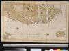
Nova tabula geographica complectens borealiorem Americae partem : in qua exacte delineatae sunt Canada sive Nova Francia, Nova Scotia, Nova Anglia, Novum Belgium, Pensylvania, Virginia, Carolina et Terra Nova : cum omnibus littorum pulvinorumque profundi
from John H. Levine Collection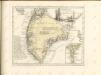
Oud Groenland van Staaten Hoek of C. Farawel tot de Visch Baij of Straet Davids int groot
Greenland Gerard van Keulen
Ice Chart, Grand Banks Region, May.
U.S. Navy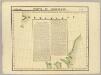
Partie de Groenland. Amer. Sep. 11.
1 : 1641836 Vandermaelen, Philippe, 1795-1869
Carte nouvelle contenant la partie d'Amerique la plus septentrionale, ou sont exactement dêcrites les provinces suivantes comme le Canada ou Nouvelle France, la Nouvelle Ecosse, la Nouvelle Angleterre, les Nouveaux Païs Bas, la Pensylvanie, la Virginie, la Caroline et l'jle de Terre Neuve, avec les profondeurs le long des côtes et sur les bancs
1 : 4000000 par Nicolas Visscher L. v. Anse schulp. [Amstelodami] : nunc apud Petrum Schenk Junior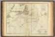
A Chart Of The Banks Of Newfoundland
1 : 2200000 Jefferys, Thomas
Ice Chart, Grand Banks Region, September, October.
U.S. Navy
Ice Chart, Grand Banks Region, March, April.
U.S. Navy
Ice Chart, Grand Banks Region, May, June.
U.S. Navy
Old Greenland.
1 : 9850000 Bowen, Emanuel
Ice Chart, Grand Banks Region, July, August.
U.S. Navy
Ice Chart, Grand Banks Region, December.
U.S. Navy
Ice Chart, Grand Banks Region, April.
U.S. Navy
Feuille 1 (A I), uit: Carte géologique internationale de l'Europe : la carte, votée au congrès géologique international de Bologne en 1881, est exécutée conformément aux décisions d'une commission internationale, avec le concours des gouvernements, sous le dir. de M.M. Beyrich et Hauchecorne
Annotatie: Blad 48 gamme des couleurs; blad 49: bladwijzer en titelblad Heinrich Ernst Beyrich 1815-1896; Wi. Hauchecorne Berlin : Reimer / (Berlin: Institut lithographique)