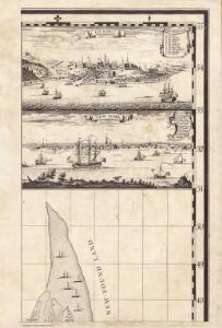
Maps of St. John's

A Map of the British Empire in America. (Sheet 4).
1 : 2000000 Popple, Henry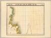
Partie, Ile de Terre Neuve. Amer. Sep. 37.
1 : 1641836 Vandermaelen, Philippe, 1795-1869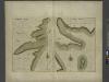
HARBOR GRACE part of new found land; BAY BULLS part of new found land
from The sea-atlas : containing an hydrographical description of most of the sea-coasts of the known parts of the world.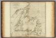
A General Chart Of The Island Of Newfoundland.
1 : 1280000 Jefferys, Thomas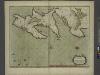
A new chart of the trading part of NEW FOUND LAND
from The sea-atlas : containing an hydrographical description of most of the sea-coasts of the known parts of the world.
Grand Banks Region, Index Chart for Ice Data Tables
U.S. Navy
Ice Chart, Grand Banks Region, February.
U.S. Navy
Ice Chart, Grand Banks Region, April.
U.S. Navy
Ice Chart, Grand Banks Region, December.
U.S. Navy
Ice Chart, Grand Banks Region, May.
U.S. Navy
Ice Chart, Grand Banks Region, June.
U.S. Navy
Newfoundland Nova Scotia And New Brunswick.
1 : 2787840 Burr, David H., 1803-1875
Newfoundland, Nova Scotia, New Brunswick, Cape Breton and Prince Edward Islands.
1 : 5800000 Schonberg & Co.
A New and correct map of the British colonies in North America comprehending eastern Canada with the province of Quebec, New Brunswick, Nova Scotia, and the Government of Newfoundland: with the adjacent states of New England, Vermont, New York, Pennsylvania and New Jersey.
from Charts and maps Publish'd by Laurie & Whittle, 53 Fleet Street: London; Robert Laurie and James Whittle,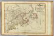
British colonies North America, New England.
1 : 3800000 Robert Laurie & James Whittle
A New and correct map of the British colonies in North America comprehending eastern Canada with the province of Quebec, New Brunswick, Nova Scotia, and the Government of Newfoundland: with the adjacent states of New England, Vermont, New York, Pennsylvania and New Jersey.
from John H. Levine Collection Publish'd by Laurie & Whittle, 53 Fleet Street: London; Robert Laurie and James Whittle,
A General Map of the Northern British Colonies in America.
1 : 3700000 Robert Sayer and John Bennett (Firm)
Generalkarte von Nord America samt den westindischen Inseln
Severní Amerika Pownall Schraembl, Franz Anton F.A. Schraembl
Newfoundland, Nova Scotia, And New Brunswick.
1 : 5800000 Greenleaf, Jeremiah
Newfoundland Nova Scotia And New Brunswick.
1 : 5680000 Greenleaf, Jeremiah
Ice Chart, Grand Banks Region, January.
U.S. Navy
A GENERAL MAP OF THE NORTHERN BRITISH COLONIES IN AMERICA
1 : 3800000 New Jersey Holland, Samuel
Drift Eis im Nordatlantischen Ocean
Atlantský oceán Redfield, W. C. D. Reimer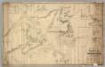
Chart From Cape Cod To Belle Isle.
1 : 1280000 Eldridge, George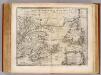
Newfoundland &c.
1 : 3250000 Bowen, Emanuel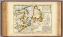
New Found Land, St. Laurence Bay, Acadia, New Scotland.
1 : 4800000 Moll, Herman, d. 1732
The coast of Nova Scotia, New England, New-York, Jersey, the Gulph and River of St. Lawrence, the islands of Newfoundland, Cape Breton, St. John, Antecosty, Sable, &c., and soundings thereof ... / by Jos. F.W. Des Barres Esqr., MDCCLXVIII.
from Charts and maps Joseph F.W. Des Barres,
The coast of Nova Scotia, New England, New-York, Jersey, the Gulph and River of St. Lawrence, the islands of Newfoundland, Cape Breton, St. John, Antecosty, Sable, &c, and soundings thereof ... / by Jos. F.W. Des Barres Esqr., MDCCLXXVII.
from Charts and maps Joseph F.W. Des Barres,
Limits under fishery treaties, 1818 and 1888
1 : 2800000 Roberts, A. C., cartographe 18..-.... [Washington, D.C.] : Hydrographic Office, Navy Department, USA