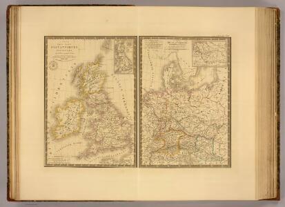
Maps of United Kingdom
Iles Britanniques ancienne, Germanie, de la Rhetie, du Norique, etc.
1 : 3800000 Picquet, C.
Map of the British Isles.
1 : 3500000 Warner & Beers
British Isles.
1 : 4100000 Cornell, S. S. (Sarah S.)
Iles Britanniques, chemins de fer, canaux.
1 : 2700000 Garnier, F. A., 1803-1863
Iles Britanniques.
1 : 2900000 Garnier, F. A., 1803-1863
British Isles.
1 : 9300000 Fenner, Rest.
Gt. Britain, Ireland.
1 : 1800000 Robert Laurie & James Whittle
A compleat map of the British Isles.
1 : 2200000 Kitchin, Thomas
Grossbritannien.
1 : 24000000 Ziegler, J. M.
Bretagne Anglo Saxonne, 600 ans apres Jesus Christ.
1 : 4500000 Houze, Antoine Philippe
Ethnographic, Gt. Brit., Ireland.
1 : 1850000 Kombst, Gustaf
Britain.
1 : 4500000 Cummings, J. A. (Jacob Abbot)
British Isles.
1 : 1680000 Pinkerton, John, 1758-1826
Angleterre, Ecosse, Irelande.
1 : 6000000 Delamarche, Charles Francois; Lattre, Jean
Carte générale des isles britanniques
1 Karte : Kupferdruck ; 76 x 51 cm Hérisson; Perrier; Basset; Basset chez Basset rue St. Jacques no. 670
General=Karte von Grossbritannien und Ireland
1 Karte : Kupferdruck ; 27 x 23 cm Reilly F. J. J. von Reilly
Mappa insularum Britannicarum antiquarum
1 Karte : Kupferdruck ; 32 x 21 cm Bonne; Perrier; André s.n.
Carte des royaumes d'Angleterre, d'Ecosse et d'Irlande
1 Karte : Kupferdruck ; 31 x 21 cm Bonne; Perrier s.n.
Des isles Britanniques
1 Karte : Kupferdruck ; 31 x 29 cm, Bildgrösse 32 x 55 cm Clouet Mondhare
Royaume Uni, Angleterre, Ecosse, et Irlande 1603 a 1839.
1 : 4500000 Houze, Antoine Philippe
Grossbritannien, Ireland.
1 : 3800000 Flemming, Carl
Britischen Inseln.
1 : 1800000 Kiepert, Heinrich, 1818-1899
British Islands.
1 : 5500000 Fitch, George W.
Gt. Britain, Ireland.
1 : 4800000 Mitchell, Samuel Augustus
Iles Britanniques.
1 : 2500000 Andriveau-Goujon, J.
British Isles.
1 : 5000000 Adams, Daniel
United Kingdom of England, Scotland and Ireland.
1 : 4500000 Worcester, J. E.
Map of the British Isles
1 : 908500 Shetlandy (Skotsko) Cary, John
Angleterre, Irelande & Ecosse 1281 a 1400.
1 : 4500000 Houze, Antoine Philippe