Maps of Newark

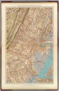
Newark, Elizabeth, the Oranges.
1 : 31680 Vermeule, C. C. (Cornelius Clarkson), 1858-1950
Elizabeth
1 : 24000
Elizabeth
1 : 24000
Elizabeth
1 : 24000
Elizabeth
1 : 24000
Elizabeth
1 : 24000
Elizabeth
1 : 24000
Elizabeth
1 : 24000
Elizabeth
1 : 24000
Orange
1 : 24000
Orange
1 : 24000
Orange
1 : 24000
Orange
1 : 24000
Orange
1 : 24000
Orange
1 : 24000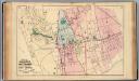
Orange, E. Orange, W. Orange.
1 : 13200 Haskell, L. S.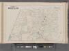
Essex County, Left Page Plate: [Part of township of Montclair] / by and under the supervision of Roger H. Pidgeon.
From Atlas of Essex County, New Jersey : from actual surveys and official records
Area District Map Section No. 20; Area district map / City of New York, Board of Estimate and Apportionment.
from Area district map / City of New York, Board of Estimate and Apportionment. New York (N.Y.). Board of Estimate and Apportionment,
Height District Map Section No. 20; Height district map / City of New York, Board of Estimate and Apportionment.
from Height district map / City of New York, Board of Estimate and Apportionment. New York (N.Y.). Board of Estimate and Apportionment,
Use District Map Section No. 20; Use district map / City of New York, Board of Estimate and Apportionment.
from Use district map / City of New York, Board of Estimate and Apportionment. New York (N.Y.). Board of Estimate and Apportionment,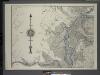
General map of the borough of Richmond (Staten Island) in the city of New York : showing in addition to the existing topographical features of the borough a tentative and preliminary plan for a street system of the same.
from Staten Island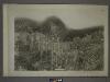
20B - N.Y. City (Aerial Set).
from Sectional aerial maps of the City of New York / [photographed and assembled under the direction of the chief engineer, July 1st, 1924].
20A - N.Y. City (Aerial Set).
from Sectional aerial maps of the City of New York / [photographed and assembled under the direction of the chief engineer, July 1st, 1924].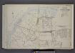
Part of Ward 3. [Map bound by State Line, Richmond (Shore Road) Terrace, Holland Ave, John St, Washington Ave, Irving PL, South Ave, Old Place Creek; Summerville - Washington Ave, South Ave, Irving PL, Garfield Ave, Dechen Ave]
from Atlas of the borough of Richmond, city of New York.
Village of Port Richmond.
from Atlas of Staten Island, Richmond County, New York, from official records and surveys; compiled and drawn by F. W. Beers.
Section 1.
from Atlas of Staten Island, Richmond County, New York, from official records and surveys; compiled and drawn by F. W. Beers.
Part of Ward 3. [Map bound by State Line, Richmond Terrace (Shore RD), Arlington Ave, Baltimore and Ohio Railroad, Western Ave, Washington Ave, Old Place Creek]
from Atlas of the city of New York, borough of Richmond, Staten Island. From actual surveys and original plans, by George W. and Walter S. Bromley.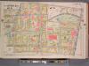
Newark, V. 1, Double Page Plate No. 4 [Map bounded by 1st St., Orange St., Newark St., Cabinet St.] / by J.M. Lathrop and L.J.G. Ogden ; assisted by E. Robinson and G.M. Monroe.
From V. 1, 1911.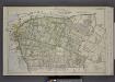
Part of Wards 1 & 3. [Map bound by Palmer's Run, Jewett Ave, Cherry Lane, Barrett Ave, Decker Ave, Richmond Ave, Prospect St, Grant St, Johnson Ave, Kill Van Kull]
from Atlas of the borough of Richmond, city of New York.