Maps of British Isles

Iles Britanniques ou Royaume Uni de la Grand Bretagne et la l'Irland.
1 : 3300000 Monin, C.V.
Brittannicae Insule ex Aevi Romani Monumentis. (1826)
1 : 3900000 Tanner, Henry S.
Stereographical map, British Isles.
1 : 1600000 Stanford, Edward
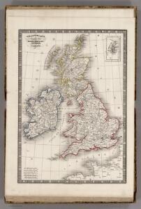
British Islands.
1 : 2300000 Morse, Jedidiah; Morse, Sidney E. (Sidney Edwards), 1794-1871
British Isles (Political).
1 : 1900000 Johnston, W. & A.K.
Iles Britanniques.
Andriveau-Goujon, J.
British Isles.
1 : 3651000 Fisher, Richard Swainson
Rainfall, temperature, British Isles.
1 : 6950000 Stanford, Edward
Novissima prae caeteris aliis accuratissima regnorum Angliae, Scotiae Hiberniaeq[ue] tabula
1 : 1850000 Irsko Wit, Frederick de F de Wit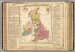
British Empire.
1 : 3200000 Lavoisne, M.
Welká Británie a Iry
1 : 3360000 Irsko Merklas, Václav
British Islands.
1 : 4700000 Grigg, John
Tabula novissima accuratissima regnorum Angliae, Scotiae Hiberniae
1 : 1850000 Irsko Seutter, Matthäus Mattheo Seutter
Welká Britanie a Iry
1 : 3400000 Irsko Merklas, Václav W. Merklas
Charte der vereinigten Königreiche Grossbritanien und Irland
1 : 2900000 Irsko Kipferling, Karl Joseph Kunst ind Industrie Comptoir
British Islands.
1 : 4000000 Schonberg & Co.
Die Britischen Inseln oder die Vereinigten Königreiche
1 : 1850000 Normanské ostrovy Kiepert, Heinrich Gräf, C. Geographisches Institut

British Islands.
1 : 3400000 Greenleaf, Jeremiah
British Islands.
1 : 3484800 Greenleaf, Jeremiah
Welká Britanie a Iry

[Neuer Atlas der ganzen Erde nach den neuesten Bestimmungen ... : XI.] Die Britischen Inseln
Entworfen und gezeichnet von Dr. F.W. Streit H. Leutemann sc. Leipzig : J.C. Hinrichs'sche Buchhandlung

General Carte von Gross Britannien
1 : 2950000 Irsko Mollo, Tranquillo Tranquillo Mollo
Philips' Railway Map of the British Isles
1 : 1087000 Edinburgh (Skotsko) George Philip & Son
The British Isles. (with) inset map of the Shetland Islands.
1 : 3801600 Tallis, J. & F.
Great Britain, Ireland.
1 : 5500000 Huntington, Nathaniel G. (Nathaniel Gilbert), 1785-1848
British Isles.
1 : 6200000 Worcester, Joseph E.
Tabula novissima accuratissima regnorum Angliæ, Scotiæ Hiberniæ
1 Karte : Kupferdruck ; 56 x 48 cm Lotter Tobias Konrad Lotter
Tabula novissima accuratissima regnorum Angliæ, Scotiæ Hiberniæ
1 Karte : Kupferdruck ; 57 x 48 cm Seutter Matthäus Seutter
Carte du gouvernement militaire d'Angleterre
1 Karte : Kupferdruck ; 16 x 15 cm, Bildgrösse 35 x 46 cm Châtelain s.n.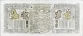
Nouvelle carte pour introduire a la geographie et a la genealogie des rois d'Angleterre et d'Ecosse
4 Karten auf 2 Blättern : Kupferdruck ; Bildgrösse 38 x 92 cm Châtelain s.n.