Maps of Spain

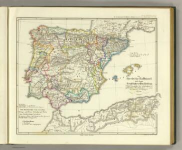
Die iberische Halbinsel nach ihrer kirchlichen Eintheilung.
1 : 3800000 Spruner von Merz, Karl
Hispania.
1 : 3800000 Menke, Th.
Carte de l'Espagne
1 Karte : Kupferdruck ; 46 x 59 cm L'Isle; Buache; Silva; Dezauche; Vallet chez Dezauche rue des Noyers
Die iberische Halbinsel seit dem Anfange des XVIten. Jahrhundert's (1479).
1 : 3800000 Spruner von Merz, Karl
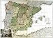
Regnorum Hispaniæ et Portugalliæ tabula generalis de l'Isliana
1 Karte : Kupferdruck ; 46 x 58 cm Homann; L'Isle Johann Baptist Homann
L'Espagne
1 Karte : Kupferdruck ; 44 x 61 cm L'Isle; Berey; Silva; Simonneau chez l'auteur sur le quai de l'horloge
Carte d'Espagne et de Portugal divisée suivant la décision des cortès et soumise aux dernières observations
1 : 2250000 par J. B. Poirson Paris : chez A. Bes et F. Dubreul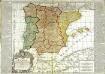
L'Espagne
1 Karte : Kupferdruck ; 48 x 56 cm, Bildgrösse 50 x 70 cm Bailleul; Daudet chez Daudet rue Merciere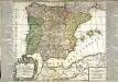
L'Espagne
1 Karte : Kupferdruck ; 49 x 56 cm, Bildgrösse 50 x 70 cm Bailleul; Daudet chez Daudet rue Merciere
Die iberische Halbinsel 1257 bis 1479.
1 : 3800000 Spruner von Merz, Karl
Emirat von Cordoba bis zum Untergange der Ommijaden; christlichen Reiche im Norden der iberischen Halbinsel 711 bis 1028.
1 : 3700000 Spruner von Merz, Karl
L'Espagne
1 Karte : Kupferdruck ; 47 x 59 cm L'Isle; Luchtenburg; Silva chez I. Covens et C. Mortier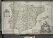
A new & exact map of Spain and Portugal, divided into its kingdoms and principalities &c. ...
from The world described, or, A new and correct sett of maps : shewing the kingdoms and states in all the known parts of the earth, with the principal cities, and most considerable towns in the world ... / ... by Herman Moll, geographer ...
Tabula Moderna Hispanie [Karte], in: [Clavdii Ptholomei Cosmographi ...], S. 251.
1 Karte aus Atlas Nicolaus Germanus [und Ptolemaeus, Claudius]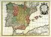
Hispania
1 Karte : Kupferdruck ; 43 x 60 cm Lotter; L'Isle; Seutter; Silva in officina Tobiæ Conr: Lotter calcogr
El reyno de España
1 Karte auf 2 Blatt : Kupferdruck ; 71 x 102 cm Longchamps en casa del autor en la calle San-Tiago a la insignia de la plaza de las victorias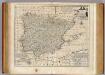
Spain and Portugal.
1 : 3500000 Bowen, Emanuel
Portugal et Hispania : ex archetypo Roderici Mendez Silvae et variis relationibus et chartis manu scriptis et impressis huius Regni rectificatis per Observationes Sociorum Academiae Scieiniarum quae est Parisiis
1 : 3200000 per G. de L'Isle Aug. Vind : in officina Tobiae Conr. Lotter
REGNORUM HISPANIAE et PORTUGALLIAE Tabula generalis
1 : 2700000 Aragonie (Španělsko) Homann, Johann Baptist Delisle, Guillaume a Ioh. Bapt. Homanno
REGNORUM HISPANIAE et PORTUGALLIAE Tabula generalis
1 : 2700000 Aragonie (Španělsko) Homann, Johann Baptist Delisle, Guillaume a Ioh. Bapt. Homanno
El reyno de España
1 Karte : Kupferdruck ; 48 x 64 cm Longchamps en casa del autor en la calle San-Tiago a la insignia de la plaza de las victorias
Hispania III. Nova Tabula [Karte], in: Geographia universalis vetus et nova complectens Claudii Ptolemaei Alexandrini enarrationis libros VIII, S. 308.
1 Karte aus Atlas Münster, Sebastian [und Ptolemaeus, Claudius]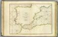
Coasts Spain, Portugal, Barbary.
1 : 3200000 Faden, William, 1750?-1836
Hispaniae Nova Descriptio, De Integro Multis In Locis, Secundum Hydrographicas Desc. Emendata. [Karte], in: Gerardi Mercatoris Atlas, sive, Cosmographicae meditationes de fabrica mundi et fabricati figura, S. 174.
1 Karte aus Atlas Mercator, Gerhard Montanus, Petrus
Reich der Westgothen, iberischen Halbinsel 477 bis 711.
1 : 3800000 Spruner von Merz, Karl
Hispania III. Nova Tabula [Karte], in: Claud. Ptolemaeus. Geographia lat. cum mappis [...], S. 338.
1 Karte aus Atlas Münster, Sebastian [und Ptolemaeus, Claudius]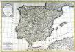
Carte des royaumes d'Espagne et de Portugal
1 Karte : Kupferdruck ; 51 x 76 cm Hérisson; Basset; Perrier; Basset chez Basset rue St. Jacques au coin de celle des Mathurins no. 64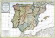
Carte des royaumes d'Espagne et de Portugal
1 Karte : Kupferdruck ; 50 x 76 cm Hérisson; Basset; Perrier; Basset chez Basset rue Jacques au coin de celle des Mathurins no. 670