Maps of Spain

Reich der Westgothen, iberischen Halbinsel 477 bis 711.
1 : 3800000 Spruner von Merz, Karl
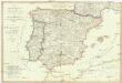
L'Espagne
1 Karte : Kupferdruck ; 47 x 59 cm L'Isle; Luchtenburg; Silva chez I. Covens et C. Mortier
Die iberische Halbinsel seit dem Anfange des XVIten. Jahrhundert's (1479).
1 : 3800000 Spruner von Merz, Karl
Regnorum Hispaniæ et Portugalliæ tabula generalis de l'Isliana
1 Karte : Kupferdruck ; 46 x 58 cm Homann; L'Isle Johann Baptist Homann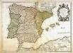
L'Espagne
1 Karte : Kupferdruck ; 44 x 61 cm L'Isle; Berey; Silva; Simonneau chez l'auteur sur le quai de l'horloge
Hispaniae Nova Descriptio, De Integro Multis In Locis, Secundum Hydrographicas Desc. Emendata. [Karte], in: Gerardi Mercatoris Atlas, sive, Cosmographicae meditationes de fabrica mundi et fabricati figura, S. 174.
1 Karte aus Atlas Mercator, Gerhard Montanus, Petrus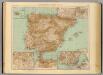
37-38. Spagna, Portogallo.
1 : 3000000 Touring club italiano
Regni Hispaniae Post Omnium Editiones Locuplessima Descriptio. [Karte], in: Theatrum orbis terrarum, S. 48.
1 Karte aus Atlas Ortelius, Abraham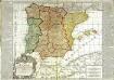
L'Espagne
1 Karte : Kupferdruck ; 48 x 56 cm, Bildgrösse 50 x 70 cm Bailleul; Daudet chez Daudet rue Merciere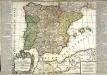
L'Espagne
1 Karte : Kupferdruck ; 49 x 56 cm, Bildgrösse 50 x 70 cm Bailleul; Daudet chez Daudet rue Merciere
Regni Hispaniae Post Omnium Editiones Locuplessima Descriptio. [Karte], in: Theatrum orbis terrarum, S. 26.
1 Karte aus Atlas Ortelius, Abraham
Hispaniae Veteris Descriptio.[Karte] [Iulia Gaditana Aug. und Umgebung] [Nebenkarte], in: Gerardi Mercatoris et I. Hondii Newer Atlas, oder, Grosses Weltbuch, Bd. 2, S. 207.
1 Karte aus Atlas Mercator, Gerhard und Hondius, Jodocus Jansson, Jan
Hispaniae Veteris Descriptio. [Karte], in: Theatrum orbis terrarum, S. 459.
1 Karte aus Atlas Ortelius, Abraham Vrients, Jan Baptista
Hispaniae Veteris Descriptio. [Karte] [Blastophoenices, Region Cádiz] [Nebenkarte], in: Theatrum orbis terrarum, S. 368.
1 Karte aus Atlas Ortelius, Abraham
Hispaniae Veteris Descriptio. [Karte] [Iulia Gaditana Aug. und Umgebung] [Nebenkarte], in: Novus atlas absolutissimus, Bd. 6, S. 8.
1 Karte aus Atlas Janssonius Offizin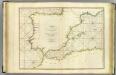
Coasts Spain, Portugal, Barbary.
1 : 3200000 Faden, William, 1750?-1836
Mapa general de España Antiqua, dividido en tres partes, Bética, Lusitánia y Tarraconénse, con la subdivision de cada una
1 : 3700000 por [...] Juan Lopez, pensionista de S.M [...] Madrid : [Thomas Lopez]
Emirat von Cordoba bis zum Untergange der Ommijaden; christlichen Reiche im Norden der iberischen Halbinsel 711 bis 1028.
1 : 3700000 Spruner von Merz, Karl
Spanien et Portugal
Neuester Schul-Atlas Walch, Johann im Verlag bei Joh. Walch

[Spanien und Portugal, Iberische Halbinsel]
Geographischer Atlas über alle Theile der Erde Ziegler, Jakob Melchior Verlag von Dietrich Reimer
Hispania III. Nova Tabula [Karte], in: Geographia universalis vetus et nova complectens Claudii Ptolemaei Alexandrini enarrationis libros VIII, S. 308.
1 Karte aus Atlas Münster, Sebastian [und Ptolemaeus, Claudius]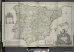
A new & exact map of Spain and Portugal, divided into its kingdoms and principalities &c. ...
from The world described, or, A new and correct sett of maps : shewing the kingdoms and states in all the known parts of the earth, with the principal cities, and most considerable towns in the world ... / ... by Herman Moll, geographer ...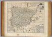
Spain and Portugal.
1 : 3500000 Bowen, Emanuel
Regni Hispaniae Post Omnium Editiones Locuplessima Descriptio. [Karte], in: Theatrum orbis terrarum, S. 95.
1 Karte aus Atlas Ortelius, Abraham Vrients, Jan Baptista
Hispaniae Et Portugalliae Regna [Karte], in: Novus atlas absolutissimus, Bd. 6, S. 18.
1 Karte aus Atlas Janssonius Offizin
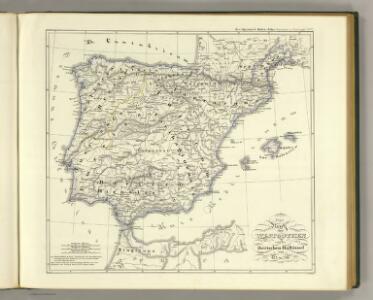
Die iberische Halbinsel nach ihrer kirchlichen Eintheilung.
1 : 3800000 Spruner von Merz, Karl
Espana y Portugal
1 : 1640000 Portugalsko López, Tomas Mauricio Tomas Mauricio Lopez
Regnorum Hispaniae nova descriptio
1 mapa, col.. Text: francès. Reclam: A, 1. - Originàriament dins: Le Theatre du monde ou novvel atlas, mis en lumiere par Gvillavme & Iean Blaeu. Amsterdam, 1643. Blaeu, Willem Jansz.; Blaeu, Joan mis en lumiere par Gvillavme & Iean Blaeu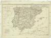
Die Königreiche Spanien und Portugal nach den neuesten Beobachtungen verfasst
1 : 2220000 Portugalsko Tranquillo Mollo