Maps of Africa
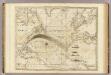
Die Luftstromungen auf dem Nordatlantishcen Ocean.
1 : 29000000 Berghaus, Heinrich
Der Atlantische Ocean
Hand-Atlas über alle Theile der Erde nach dem neuesten Zustande und über das Weltgebäude Stieler, Adolf bei Justus Perthes
[Die Luftströmungen auf dem Nordatlantischen Ocean; Im westlichen Gebiet der Alten und im Östlichen Theil der neuen Welt]
Erster Band, enthaltend in vier Abtheilungen die Erscheinungen der anorganischen Natur: 1. Meteorologie und Klimatographie. 2. Hydrologie und Hydrographie. 3. Geologie. 4. Tellurischer Magnetismus Humboldt, Alexander von Verlag von Justus Perthes
[Stromgebiete der Neuen Welt]
Erster Band, enthaltend in vier Abtheilungen die Erscheinungen der anorganischen Natur: 1. Meteorologie und Klimatographie. 2. Hydrologie und Hydrographie. 3. Geologie. 4. Tellurischer Magnetismus Humboldt, Alexander von Verlag von Justus Perthes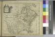
North America / drawn from the best authorities by T. Kitchin.
from A new geographical, historical, and commercial grammar : and present state of the several kingdoms of the world ... : to which are added, I. A geographical index, with the names and places alphabetically arranged ... / by William Guthrie, esq.
Map of the United States, the British provinces, Mexico, &c. : showing the routes of the U.S. mail steam packets to California and a plan of the gold region / drawn & engraved by J.M. Atwood, New York.
from Whole
Der Atlantische Ocean
Hand-Atlas über alle Theile der Erde nach dem neuesten Zustande und über das Weltgebäude Stieler, Adolf bei Justus Perthes
Carte de l'OCÉAN PACIFIQUE au Nord de l'Equateur, et des Côtes qui le bornent des deux côtés
Tichý oceán-oblast severní Lotter, Tobias Conrad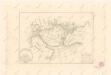
Calculus Eclipsis Solis Observatae die 19. Novemberis 1816

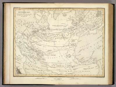
Carte von Asien
1 : 21000000 Asie Walch, Johann Johannes Walch
[Karte vom atlantischen Ocean; Zur Übersicht der Strömungen und Handelsstrassen, der Wärme-Verbreitung, des Seebodens]
Erster Band, enthaltend in vier Abtheilungen die Erscheinungen der anorganischen Natur: 1. Meteorologie und Klimatographie. 2. Hydrologie und Hydrographie. 3. Geologie. 4. Tellurischer Magnetismus Humboldt, Alexander von Verlag von Justus Perthes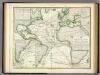
Karte vom Atlantischen Ocean.
1 : 90000000 Berghaus, Heinrich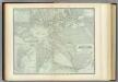
Atlantic Ocean.
1 : 31000000 Johnston, Alexander Keith, 1804-1871
Asia.
1 : 40000000 Mitchell, Samuel Augustus
Asia.
1 : 40000000 Mitchell, Samuel Augustus
Atlantic cables, wireless stations.
1 : 40000000 Philip, George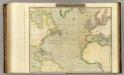
N. Atlantic Ocean.
1 : 22500000 Thomson, John
Asia (physical).
1 : 43819000 Fisher, Richard Swainson
A new, plaine, and exact map of Asia described by N.I. Visscher, and done into English, enlarged, and corrected, according to I. Blaeu, with the habits of ye countries, and manner of the cheife citties, ye like never before
1 : 28000000
Asien
Asie Schmidt, Johann Marius Friedrich Franz Simon Schropp
Carte de l'ocean Atlantique
1 Karte : Kupferdruck ; 47 x 61 cm Jefferys; Le Rouge chez Le Rouge rue des g.ds Augustins
Carte de l'océan Atlantique
1 Karte : Kupferdruck ; 48 x 61 cm Lattré chéz Lattré graveur du roy rue St. Jacques la porte cochère vis avis la rue de la Parcheminerie
Karte des Atlantischen Oceans
1 Karte : Kupferdruck ; 48 x 60 cm Schrämbl zu finden in eigenem Verlage Schrämbl
Asia.
1 : 55000000 Lucas, Fielding Jr.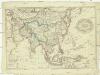
Asien
1 : 33600000 Asie T. Mollo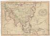
Asien
1 : 20200000 Asie Mollo, Tranquillo T. Mollo
A new generall chart for the West Indies....
from English pilot. The fourth book.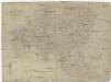
Asien
1 : 32180000 Asie Mollo, Tranquillo T. Mollo
Chart of the Atlantic Ocean, with the British, French, & Spanish settlements in North America and the West Indies : as also on the coast of Africa / by Thos. Jefferys, geographer to His Majesty.
from Atlantic Ocean